Disclosure : This site contains affiliate links to products. We may receive a commission for purchases made through these links.
Stourbridge (North) & Amblecote 1901 – 4.10a
Stourbridge North and Amblecote in 1901 in a fascinating series of reproductions of old Ordnance Survey plans in the Alan Godfrey Editions, ideal for anyone interested in the history of their neighbourhood or family. The map covers the northern part of Stourbridge, in Worcestershire, and also extends north to Coalbournbrook and a stretch of Amblecote from Staffordshire sheet 71.10. Coverage extends from Wollaston Hall eastward to Amblecote Bank. Features include GWR Oxford Worcester & Wolverhampton line but no stations, Stourbridge Town branch with Town station, Stourbridge town centre with Market Hall and St Thomas church, St John`s church, Bedcote Mill, Bouchall area, Stambermill area, River Stour Works, St Mark`s church, brick works, River Stour, Stourbridge Canal, Wollaston Hall, coal shafts for northern Hungary Hill Mines, Amblecote Works with mineral railway, Ravensitch area, Amblecote Bank, Aston`s Fold area, Holloway End area, Corbett Hospital, Dennis Hall, Dennis glass works, Coalbournbrook, etc. On the reverse is a list of private residents from an 1896 Stourbridge directory. About the Alan Godfrey Editions of the 25″ OS Series:Selected towns in Great Britain and Ireland are covered by maps showing the extent of urban development in the last decades of the 19th and early 20th century. The plans have been taken from the Ordnance Survey mapping and reprinted at about 15 inches to one mile (1:4,340). On the reverse most maps have historical notes and many also include extracts from contemporary directories. Most maps cover about one mile (1.6kms) north/south, one and a half miles (2.4kms) across; adjoining sheets can be combined to provide wider coverage.FOR MORE INFORMATION AND A COMPLETE LIST OF ALL AVAILABLE TITLES PLEASE CLICK ON THE SERIES LINK.

Related Products:
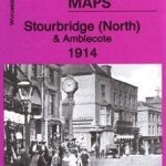 Stourbridge (North) & Amblecote 1914 – 4.10b
 Wollaston 1901 – 4.09
Wolverhampton North West 1901
Stourbridge South and Oldswinford 1914
Wollaston 1901 – 4.09
Wolverhampton North West 1901
Stourbridge South and Oldswinford 1914
 Cambridge (North) 1901 – 40.14
 South Bank and Grangetown North 1927
Mexborough 1901
Wolverhampton (SW) 1901 – 62.10
Stourport 1901
Darlaston & King`s Hill 1901
Swinton 1901
Newtownards 1901
Loughborough 1901
Wath upon Dearne 1901
South Bank and Grangetown North 1927
Mexborough 1901
Wolverhampton (SW) 1901 – 62.10
Stourport 1901
Darlaston & King`s Hill 1901
Swinton 1901
Newtownards 1901
Loughborough 1901
Wath upon Dearne 1901
 Cradley Heath and Old Hill 1901
 Wolverhampton (SE) 1901 – 62.11b
 Pendleton North 1915
Kilnhurst 1901
Pendleton North 1915
Kilnhurst 1901
 Swansea (North) 1897 – 24.01
Cradley South 1901
Swansea (North) 1897 – 24.01
Cradley South 1901
 Willenhall (NW) & Wednesfield 1901 – 62.08a
Smethwick 1901 – 72.03a
Manchester North West and Central Salford 1915
Bangor East 1901
Bangor West 1901
Middlesbrough North 1913
Blandford Forum 1901
Willenhall (NW) & Wednesfield 1901 – 62.08a
Smethwick 1901 – 72.03a
Manchester North West and Central Salford 1915
Bangor East 1901
Bangor West 1901
Middlesbrough North 1913
Blandford Forum 1901
 Workington North 1923
 Walsall (SE) 1901 – 63.11
Middlesbrough North 1893 (Colour Edition)
Conisbrough 1901
North Kirkcaldy & Dysart 1894 – 36.05
Bridport 1901
Walsall (SE) 1901 – 63.11
Middlesbrough North 1893 (Colour Edition)
Conisbrough 1901
North Kirkcaldy & Dysart 1894 – 36.05
Bridport 1901
 Oldbury & Spon Lane 1904 – 68.14a
Willenhall North East 1885
Oldbury & Spon Lane 1904 – 68.14a
Willenhall North East 1885
 Bollington 1907
Dumfries North 1899
Bollington 1907
Dumfries North 1899
 Northwich North East 1908
Leeds Central and North East 1890
Harborne South 1901
Northwich North East 1908
Leeds Central and North East 1890
Harborne South 1901