Disclosure : This site contains affiliate links to products. We may receive a commission for purchases made through these links.
Storsteinhalvรธya
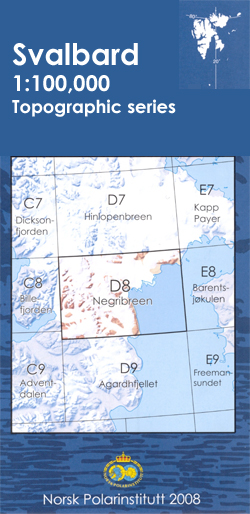
One of the titles in the topographic survey of the Svalbard group still published only in a black and white version, without geographical names. These maps cover parts of the northern and north-eastern Spitzbergen, Nordaustlandet, Edgeรธya and some of the small islands.The western coast, central and southern part of Spitzbergen, plus two small islands of Svenskรธya and Kongsรธyaare are now available in colour versions, with contours at 25-metre intervals, bold relief shading and spot heights. The maps settlements, roads and tracks, working and disused mines, airfields, lighthouses and radio beacons, etc. A grid gives UTM co-ordinates plus latitude in steps of 10` and longitude in 20’.

Related Products:
 Vaigattbogen
Hinlopenbreen
Austfjorden
Woodfjorden
Eidsvollfjellet
Sjuรธyane
Rijpfjorden
Snรธtoppen
Mosselhalvรธya
ร…sgรฅrdfonna
Nordenskiรถldbukta
Gotiahalvรธya
St. Johnsfjorden
Tre Kroner
Adventdalen
Negribreen
Dicksonfjorden
Van Mijenfjorden
Isfjorden
Agardhfjellet
Kongsfjorden
Magdalenefjorden
Krossfjorden
Reinsdyrflya
Braganzavรฅgen
Vasahalvรธya
Prins Karls Forland
Norway: 100K Topographic Survey of Svalbard/Spitsbergen
Vaigattbogen
Hinlopenbreen
Austfjorden
Woodfjorden
Eidsvollfjellet
Sjuรธyane
Rijpfjorden
Snรธtoppen
Mosselhalvรธya
ร…sgรฅrdfonna
Nordenskiรถldbukta
Gotiahalvรธya
St. Johnsfjorden
Tre Kroner
Adventdalen
Negribreen
Dicksonfjorden
Van Mijenfjorden
Isfjorden
Agardhfjellet
Kongsfjorden
Magdalenefjorden
Krossfjorden
Reinsdyrflya
Braganzavรฅgen
Vasahalvรธya
Prins Karls Forland
Norway: 100K Topographic Survey of Svalbard/Spitsbergen
 Longyearbyen and surroundings
 Nordenskiรถld Land
 Svalbard South-East
Svalbard North-West
Svalbard South-West
Svalbard South-East
Svalbard North-West
Svalbard South-West
 Svalbard North-East
 Bjornoya
Svalbard North
Bjornoya
Svalbard North
 Svalbard Topographic Map
 Svalbard Tourist Map
 Jan Mayen
Norway: 250K Topographic Survey of Svalbard/Spitsbergen
Jan Mayen
Norway: 250K Topographic Survey of Svalbard/Spitsbergen