Disclosure : This site contains affiliate links to products. We may receive a commission for purchases made through these links.
Stirling, Forth Valley & The Trossachs Cycling Map
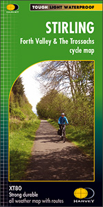
Stirling, Forth Valley and the Trossachs Cycling Map at 1:80,000 from Harvey Map Services, printed on light, waterproof and tear-resistant paper, with cycle trails in Stirling itself, plus 16 tours in the surrounding area including the Loch Lomond Loop.On one side a map at 1:80,000 covers an area from west of Loch Lomond to the Ochil Hills and the Firth of Forth. Contours at 75m intervals enhanced by shading and altitude colouring show the topography. 16 tours are prominently highlighted, graded into easy, medium and difficult and indicating whether on road or traffic free. Symbols show campsites and caravan parks, car parks, bus stations, refreshments and cafes, golf courses, etc. The map has the lines of the British National Grid at 2km intervals.On the reverse each of the recommended routes has a separate panel with a description, an overview map, plus details of access, distance and terrain, etc. Also included is a large street plan of Stirling showing on and off-road cycle paths in the city, National Cycle Network routes, etc.To see the other titles in this series please click on the series link.

Related Products:
 Stirling & The Trossachs OS Landranger Map 57 (paper)
 Lochside Walks: The Finest Waterside Walks in Loch Lomond & the Trossachs
 Stirling & The Trossachs OS Landranger Active Map 57 (waterproof)
 Day Walks in Loch Lomond & the Trossachs: 20 routes in the southern Scottish Highlands
 Loch Lomond, The Trossachs: 2016
 Pub Walks – The Best Pub Walks in Loch Lomond & Trossachs
 Loch Lomond & the Trossachs National Park Outdoor Atlas
 Loch Lomond & The Trossachs – Ben Lomond & Loch Katrine Harvey Superwalker XT25
 Walking Loch Lomond and the Trossachs: 70 walks, including 21 Munro summits
 Glasgow – Stirling & the Clyde Sustrans Cycle Map 41
 Ben Venue – Loch Ard Forest & the Trossachs Harvey Superwalker
 Loch Lomond & the Trossachs V1: West
 Loch Lomond and The Trossachs
 Top 10 Walks: Loch Lomond & the Trossachs
 Hill Walks & Easy Summits: Walks on the Lower Hills of Loch Lomond & the Trossachs
 Oban, Kintyre & the Trossachs 110K Sustrans Cycle Map No. 42
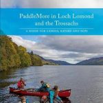 PaddleMore in Loch Lomond and The Trossachs: A Guide for Canoes, Kayaks and SUPs
 Mountain Walks – Finest Mountain Walks in Loch Lomond & Trossachs
 Stirling & Ochil Hills West – Alloa & Dunblane OS Explorer Map 366 (paper)
 Loch Lomond & The Trossachs Harvey Ultramap XT40
 Stirling & Ochil Hills West – Alloa & Dunblane OS Explorer Active Map 366 (waterproof)
Edinburgh, Stirling & the Forth Sustrans Cycle Map 40
Stirling & Ochil Hills West – Alloa & Dunblane OS Explorer Active Map 366 (waterproof)
Edinburgh, Stirling & the Forth Sustrans Cycle Map 40
 Walks The Trossachs
 The Great Trossachs Path Harvey National Trail XT40
 Loch Lomond & Trossachs Mazzle – Jigsaw 1000 Pieces
 Arrochar Alps Harvey Superwalker XT25
 The Trossachs – Callander, Aberfoyle & Lochearnhead, Balquhidder & Strathyre OS Explorer Map OL46 (paper)
 The Trossachs – Callander, Aberfoyle & Lochearnhead, Balquhidder & Strathyre OS Explorer Active Map OL46 (waterproof)
 Stirling & Falkirk Weeked Walks
 Koblenz – Bonn – Mainz – Middle Rhine Valley Cycling Map
 Loch Lomond National Park Collins Pocket Map
 Stirling, Bannockburn and Bridge of Allan
 Lochs & Glens North Cycle Route
 Loch Lomond & Cowal Way: with Isle of Bute
 Stirling & Central Scotland Pevsner Architectural Guide
 Great Glen & Loch Ness 110K Sustrans Cycle Map No. 47
 South Devon Cycling Map 83
 Mt Arthur and the Cobb Valley
 Alsace – Upper Rhine Regional Cycling Map
 Loch Lomond South – Dumbarton, Helensburgh, Drymen & Cove OS Explorer Map OL38 (paper)