Disclosure : This site contains affiliate links to products. We may receive a commission for purchases made through these links.
Stanford`s Western Hemisphere Map (1877) – A1 Wall Map, Canvas
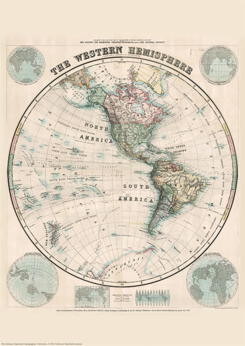
THIS ITEM IS AVAILABLE FOR CLICK AND COLLECT BUT PLEASE ALLOW UP TO 5 WORKING DAYS FOR THE PRINT TO BE PRODUCED. WE WILL EMAIL YOU CONFIRMATION WHEN THE ITEM IS READY FOR COLLECTION.The Stanford’s Map of The Western Hemisphere is from a fascinating series of reproductions from our Edward Stanford Cartographic Collection archive.The original map from 1877 was drawn by Stanford’s Geographical Establishment and ‘published under the direction of the Committee of General Literature and Education Appointed by The Society for Promoting Christian Knowledge and of the National Society”. On this stereographic projection, individual countries are presented in gentle pastel hues typical of hand-coloured maps, with their borders outlined in stronger colours. The publication date of 1877 gives us the Americas more or less as we know it now but Antarctica with only a handful of coastal places named and believed to be flat.Hachures are used to show the mountain ranges and many other features of contemporary cartography are included: ocean currents and trade winds, surrounding frames showing the tropical zones and the position of the sun, etc. Latitude and longitude lines are drawn at 10ยฐ intervals. Additional panels on this map of the Western Hemisphere give examples of six different map projections, including Mercator’s projection and the gores of a globe complete on the same scale at the equator.This is the A1 canvas version.PLEASE NOTE: the eastern hemisphere is available separately, as is a landscape format reproduction that combines the two maps together.

Related Products:
 Stanford`s Western Hemisphere Map (1877) – A2 Wall Map, Canvas
Stanford`s Western Hemisphere Map (1877) – Original Size Wall Map, Canvas
Stanford`s Western Hemisphere Map (1877) – A3 Wall Map, Paper
Stanford`s Western Hemisphere Map (1877) – A2 Wall Map, Paper
Stanford`s Western Hemisphere Map (1877) – A1 Wall Map, Paper – Print on Demand
Stanford`s Western Hemisphere Map (1877) – Original Size Wall Map, Paper
Stanford`s Western Hemisphere Map (1877) – A2 Wall Map, Canvas
Stanford`s Western Hemisphere Map (1877) – Original Size Wall Map, Canvas
Stanford`s Western Hemisphere Map (1877) – A3 Wall Map, Paper
Stanford`s Western Hemisphere Map (1877) – A2 Wall Map, Paper
Stanford`s Western Hemisphere Map (1877) – A1 Wall Map, Paper – Print on Demand
Stanford`s Western Hemisphere Map (1877) – Original Size Wall Map, Paper
 Stanford`s Eastern Hemisphere Map (1877) – A3 Wall Map, Canvas
Stanford`s Eastern Hemisphere Map (1877) – A2 Wall Map, Canvas
Stanford`s Eastern Hemisphere Map (1877) – A1 Wall Map, Canvas
Stanford`s Eastern Hemisphere Map (1877) – Original Size Wall Map, Canvas
Stanford`s Eastern Hemisphere Map (1877) – A3 Wall Map, Canvas
Stanford`s Eastern Hemisphere Map (1877) – A2 Wall Map, Canvas
Stanford`s Eastern Hemisphere Map (1877) – A1 Wall Map, Canvas
Stanford`s Eastern Hemisphere Map (1877) – Original Size Wall Map, Canvas
 Stanford`s Eastern and Western Hemispheres Map (1877) – A3 Wall Map, Canvas
Stanford`s Eastern and Western Hemispheres Map (1877) – A2 Wall Map, Canvas
Stanford`s Eastern and Western Hemispheres Map (1877) – A1 Wall Map, Canvas
Stanford`s Eastern Hemisphere Map (1877) – A3 Wall Map, Paper
Stanford`s Eastern Hemisphere Map (1877) – A2 Wall Map, Paper
Stanford`s Eastern and Western Hemispheres Map (1877) – Original Size Wall Map, Canvas
Stanford`s Eastern Hemisphere Map (1877) – A1 Wall Map, Paper – Print on Demand
Stanford`s Eastern Hemisphere Map (1877) – Original Size Wall Map, Paper
Stanford`s Eastern and Western Hemispheres Map (1877) – A3 Wall Map, Canvas
Stanford`s Eastern and Western Hemispheres Map (1877) – A2 Wall Map, Canvas
Stanford`s Eastern and Western Hemispheres Map (1877) – A1 Wall Map, Canvas
Stanford`s Eastern Hemisphere Map (1877) – A3 Wall Map, Paper
Stanford`s Eastern Hemisphere Map (1877) – A2 Wall Map, Paper
Stanford`s Eastern and Western Hemispheres Map (1877) – Original Size Wall Map, Canvas
Stanford`s Eastern Hemisphere Map (1877) – A1 Wall Map, Paper – Print on Demand
Stanford`s Eastern Hemisphere Map (1877) – Original Size Wall Map, Paper
 Stanfords Western Hemisphere Wall Map c.1877 LARGE
Stanford`s Eastern and Western Hemispheres Map (1877) – A3 Wall Map, Paper
Stanford`s Eastern and Western Hemispheres Map (1877) – A2 Wall Map, Paper
Stanford`s Eastern and Western Hemispheres Map (1877) – A1 Wall Map, Paper
Stanfords Western Hemisphere Wall Map c.1877 LARGE
Stanford`s Eastern and Western Hemispheres Map (1877) – A3 Wall Map, Paper
Stanford`s Eastern and Western Hemispheres Map (1877) – A2 Wall Map, Paper
Stanford`s Eastern and Western Hemispheres Map (1877) – A1 Wall Map, Paper
 Western Hemisphere: Stanfords Map from 1877 SMALL
Stanford`s Eastern and Western Hemispheres Map (1877) – Original Size Wall Map, Paper
Western Hemisphere: Stanfords Map from 1877 SMALL
Stanford`s Eastern and Western Hemispheres Map (1877) – Original Size Wall Map, Paper
 Stanford`s Pacific-centred World Map (1884) – Original Size Wall Map, Canvas
 Eastern Hemisphere: Stanfords Map from 1877 SMALL
Stanford`s Pacific-centred World Map (1884) – Original Size Wall Map, Paper
Eastern Hemisphere: Stanfords Map from 1877 SMALL
Stanford`s Pacific-centred World Map (1884) – Original Size Wall Map, Paper
 Stanford`s Map of the British Metropolis: London (1877) – A4 Wall Map, Canvas
Stanford`s Map of the British Metropolis: London (1877) – A3 Wall Map, Canvas
Stanford`s Map of the British Metropolis: London (1877) – A2 Wall Map, Canvas
Stanford`s Map of the British Metropolis: London (1877) – A1 Wall Map, Canvas
Stanford`s Map of the British Metropolis: London (1877) – A1 Wall Map, Paper – Print on Demand
Stanford`s Map of the British Metropolis: London (1877) – A4 Wall Map, Canvas
Stanford`s Map of the British Metropolis: London (1877) – A3 Wall Map, Canvas
Stanford`s Map of the British Metropolis: London (1877) – A2 Wall Map, Canvas
Stanford`s Map of the British Metropolis: London (1877) – A1 Wall Map, Canvas
Stanford`s Map of the British Metropolis: London (1877) – A1 Wall Map, Paper – Print on Demand
 Stanford`s Library Map of the World (1879) – A3 Wall Map, Canvas
Stanford`s Library Map of the World (1879) – A2 Wall Map, Canvas
Stanford`s Library Map of the World (1879) – A1 Wall Map, Canvas
Stanford`s Map of the British Metropolis: London (1877) – A2 Wall Map, Paper
Stanford`s Map of the British Metropolis: London (1877) – A3 Wall Map, Paper
Stanford`s Library Map of the World (1879) – A3 Wall Map, Canvas
Stanford`s Library Map of the World (1879) – A2 Wall Map, Canvas
Stanford`s Library Map of the World (1879) – A1 Wall Map, Canvas
Stanford`s Map of the British Metropolis: London (1877) – A2 Wall Map, Paper
Stanford`s Map of the British Metropolis: London (1877) – A3 Wall Map, Paper
 A5 Postcard – Stanford`s Eastern and Western Hemispheres Map
 Map of Discovery – Western Hemisphere NGS Wall Map PAPER
 Stanford`s Library Map of the World (1879) – Original Size Wall Map, Canvas