Disclosure : This site contains affiliate links to products. We may receive a commission for purchases made through these links.
Stanford`s Pacific-centred World Map (1884) – A3 Wall Map, Canvas
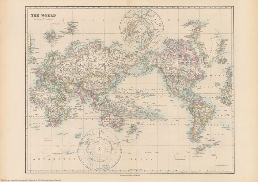
The Stanford’s Pacific-centred World Map is from a fascinating series of reproductions from our Edward Stanford Cartographic Collection archive.Originally published in 1884, this political wall map is drawn on a Mercator’s projection presenting the world with the Pacific Ocean at its centre. Political boundaries are coloured in bold, gradually shading lighter as is typical in maps from this time. Latitude and longitude lines are at 10ยฐ intervals.Europe and Africa look very different from today, Asia with many changes mainly in the Middle East, but the Americas mostly unchanged. A particularly interesting feature of the map is the difference in the presentation of the two Polar Regions: the Arctic Ocean with most of its coastline already there, whilst the Antarctic is still in the early stages of exploration and only segments of its coast already mapped. Separate panels show lands contiguous to the North and South Poles, drawn to the equatorial scale of the map.This is the A3 canvas version.

Related Products:
 Stanford`s Pacific-centred World Map (1884) – A4 Wall Map, Canvas
Stanford`s Pacific-centred World Map (1884) – A2 Wall Map, Canvas
Stanford`s Pacific-centred World Map (1884) – A1 Wall Map, Canvas – Print on Demand
Stanford`s Pacific-centred World Map (1884) – A3 Wall Map, Paper
Stanford`s Pacific-centred World Map (1884) – A2 Wall Map, Paper
Stanford`s Pacific-centred World Map (1884) – A1 Wall Map, Paper
Stanford`s Pacific-centred World Map (1884) – Original Size Wall Map, Canvas
Stanford`s Pacific-centred World Map (1884) – A4 Wall Map, Canvas
Stanford`s Pacific-centred World Map (1884) – A2 Wall Map, Canvas
Stanford`s Pacific-centred World Map (1884) – A1 Wall Map, Canvas – Print on Demand
Stanford`s Pacific-centred World Map (1884) – A3 Wall Map, Paper
Stanford`s Pacific-centred World Map (1884) – A2 Wall Map, Paper
Stanford`s Pacific-centred World Map (1884) – A1 Wall Map, Paper
Stanford`s Pacific-centred World Map (1884) – Original Size Wall Map, Canvas
 World: Stanfords Pacific Centred Map of the World 1884 SMALL
Stanford`s Pacific-centred World Map (1884) – Original Size Wall Map, Paper
World: Stanfords Pacific Centred Map of the World 1884 SMALL
Stanford`s Pacific-centred World Map (1884) – Original Size Wall Map, Paper
 Stanfords Pacific-Centred World Map (1884) 60×80 Canvas Print
 Stanford`s Library Map of the World (1879) – A3 Wall Map, Canvas
Stanford`s Library Map of the World (1879) – A2 Wall Map, Canvas
Stanford`s Library Map of the World (1879) – A1 Wall Map, Canvas
Stanford`s Library Map of the World (1879) – A3 Wall Map, Canvas
Stanford`s Library Map of the World (1879) – A2 Wall Map, Canvas
Stanford`s Library Map of the World (1879) – A1 Wall Map, Canvas
 Stanford`s Library Map of the World (1879) – Original Size Wall Map, Canvas
 Stanford`s General Map of the World (1920) – A3 Wall Map, Canvas
Stanford`s General Map of the World (1920) – A2 Wall Map, Canvas
Stanford`s General Map of the World (1920) – A1 Wall Map, Canvas
Stanford`s General Map of the World (1920) – A3 Wall Map, Canvas
Stanford`s General Map of the World (1920) – A2 Wall Map, Canvas
Stanford`s General Map of the World (1920) – A1 Wall Map, Canvas
 Stanford`s New Library Chart of the World (1920) – A3 Wall Map, Canvas
Stanford`s New Library Chart of the World (1920) – A2 Wall Map, Canvas
Stanford`s New Library Chart of the World (1920) – A1 Wall Map, Canvas
Stanford`s New Library Chart of the World (1920) – A3 Wall Map, Canvas
Stanford`s New Library Chart of the World (1920) – A2 Wall Map, Canvas
Stanford`s New Library Chart of the World (1920) – A1 Wall Map, Canvas
 Stanford`s South Polar Chart (1901) – A3 Wall Map, Canvas
Stanford`s South Polar Chart (1901) – A2 Wall Map, Canvas
Stanford`s South Polar Chart (1901) – A1 Wall Map, Canvas
Stanford`s General Map of the World (1920) – XL Size (120 x 80cm) Wall Map, Canvas
Stanford`s South Polar Chart (1901) – A3 Wall Map, Canvas
Stanford`s South Polar Chart (1901) – A2 Wall Map, Canvas
Stanford`s South Polar Chart (1901) – A1 Wall Map, Canvas
Stanford`s General Map of the World (1920) – XL Size (120 x 80cm) Wall Map, Canvas
 Stanford`s New Library Chart of the World (1920) – Original Size Wall Map, Canvas – Print on Demand
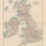 Stanford`s Folio British Isles Map (1884) – A1 Wall Map, Canvas – Special Edition
 Stanford`s Folio British Isles Map (1884) – A2 Wall Map, Canvas
 Stanford`s Folio North America Map (1884) – A4 Wall Map, Canvas
Stanford`s Folio North America Map (1884) – A3 Wall Map, Canvas
Stanford`s Folio North America Map (1884) – A2 Wall Map, Canvas
Stanford`s Folio British Isles Map (1884) – A4 Wall Map, Canvas
Stanford`s Folio British Isles Map (1884) – A3 Wall Map, Canvas
Stanford`s Folio British Isles Map (1884) – A1 Wall Map, Canvas
Stanford`s Folio North America Map (1884) – A4 Wall Map, Canvas
Stanford`s Folio North America Map (1884) – A3 Wall Map, Canvas
Stanford`s Folio North America Map (1884) – A2 Wall Map, Canvas
Stanford`s Folio British Isles Map (1884) – A4 Wall Map, Canvas
Stanford`s Folio British Isles Map (1884) – A3 Wall Map, Canvas
Stanford`s Folio British Isles Map (1884) – A1 Wall Map, Canvas
 World & Flags Hema Political Pacific-Centred
 Stanford`s Folio Japan Map (1884) – A3 Wall Map, Canvas
Stanford`s Folio Japan Map (1884) – A2 Wall Map, Canvas
Stanford`s Folio Japan Map (1884) – A1 Wall Map, Canvas
Stanford`s Folio Japan Map (1884) – A3 Wall Map, Canvas
Stanford`s Folio Japan Map (1884) – A2 Wall Map, Canvas
Stanford`s Folio Japan Map (1884) – A1 Wall Map, Canvas
 Stanford`s Folio Europe Map, by J. Arrowsmith (1884) – A3 Wall Map, Canvas
Stanford`s Folio Europe Map, by J. Arrowsmith (1884) – A2 Wall Map, Canvas
Stanford`s Folio Europe Map, by J. Arrowsmith (1884) – A1 Wall Map, Canvas
Stanford`s Folio Europe Map, by J. Arrowsmith (1884) – A3 Wall Map, Canvas
Stanford`s Folio Europe Map, by J. Arrowsmith (1884) – A2 Wall Map, Canvas
Stanford`s Folio Europe Map, by J. Arrowsmith (1884) – A1 Wall Map, Canvas