Disclosure : This site contains affiliate links to products. We may receive a commission for purchases made through these links.
Stanford`s New Map of Kabul (1880) – Original Size Wall Map, Canvas
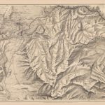
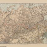
The Stanford’s New Map of Kabul is from a fascinating series of reproductions from our Edward Stanford Cartographic Collection archive.This map was published by Stanfords in January 1880 and says ‘Stanford’s New Map of Kabul and the country round as far as Kohistan, Tagao, and Lughman: Gandamak, Kurram, and Shutargardan; The Upper Logar; Maidan and Argandi; with the sites of all the recent conflicts.’ The whole map is tonal except for a few red and blue lines. One of which indicates the route of Lieutenant Vincent Eyre and the other captives. Another shows General Roberts’ advance.This is a beautiful historic map with lots of regions fascinatingly still marked as ‘unexplored’.This is the full original size version on canvas. Dimensions: 101 x 68.5cm (hor x ver)

Related Products:
 Stanford`s New Map of Kabul (1880) – A3 Wall Map, Canvas
Stanford`s New Map of Kabul (1880) – A2 Wall Map, Canvas
Stanford`s New Map of Kabul (1880) – A1 Wall Map, Canvas
Stanford`s New Map of Kabul (1880) – A3 Wall Map, Paper
Stanford`s New Map of Kabul (1880) – A2 Wall Map, Paper
Stanford`s New Map of Kabul (1880) – Original Size Wall Map, Paper
Stanford`s New Map of Kabul (1880) – A1 Wall Map, Paper – Print on Demand
Stanford`s New Map of Kabul (1880) – A3 Wall Map, Canvas
Stanford`s New Map of Kabul (1880) – A2 Wall Map, Canvas
Stanford`s New Map of Kabul (1880) – A1 Wall Map, Canvas
Stanford`s New Map of Kabul (1880) – A3 Wall Map, Paper
Stanford`s New Map of Kabul (1880) – A2 Wall Map, Paper
Stanford`s New Map of Kabul (1880) – Original Size Wall Map, Paper
Stanford`s New Map of Kabul (1880) – A1 Wall Map, Paper – Print on Demand
 A5 Postcard – Stanford`s New Map of Kabul
 Stanford`s Route Map of the Earth Colour (1854) – A3 Wall Map, Canvas
Stanford`s Route Map of the Earth Colour (1854) – A2 Wall Map, Canvas
Stanford`s Route Map of the Earth Colour (1854) – A1 Wall Map, Canvas
Stanford`s Route Map of the Earth Colour (1854) – A3 Wall Map, Canvas
Stanford`s Route Map of the Earth Colour (1854) – A2 Wall Map, Canvas
Stanford`s Route Map of the Earth Colour (1854) – A1 Wall Map, Canvas
 Stanford`s Route Map of the Earth Black and White (1853) – A3 Wall Map, Canvas
Stanford`s Route Map of the Earth Black and White (1853) – A2 Wall Map, Canvas
Stanford`s Route Map of the Earth Black and White (1853) – A3 Wall Map, Canvas
Stanford`s Route Map of the Earth Black and White (1853) – A2 Wall Map, Canvas
 Stanford`s South Polar Chart (1901) – A3 Wall Map, Canvas
Stanford`s South Polar Chart (1901) – A2 Wall Map, Canvas
Stanford`s South Polar Chart (1901) – A1 Wall Map, Canvas
Stanford`s South Polar Chart (1901) – A3 Wall Map, Canvas
Stanford`s South Polar Chart (1901) – A2 Wall Map, Canvas
Stanford`s South Polar Chart (1901) – A1 Wall Map, Canvas
 Stanford`s General Map of the World (1920) – A3 Wall Map, Canvas
Stanford`s General Map of the World (1920) – A2 Wall Map, Canvas
Stanford`s General Map of the World (1920) – A1 Wall Map, Canvas
Stanford`s General Map of the World (1920) – A3 Wall Map, Canvas
Stanford`s General Map of the World (1920) – A2 Wall Map, Canvas
Stanford`s General Map of the World (1920) – A1 Wall Map, Canvas
 Stanford`s Tourists` Map of Europe (1928) – A4 Wall Map, Canvas
Stanford`s Tourists` Map of Europe (1928) – A3 Wall Map, Canvas
Stanford`s Tourists` Map of Europe (1928) – A2 Wall Map, Canvas
Stanford`s Tourists` Map of Europe (1928) – A1 Wall Map, Canvas
Stanford`s Tourists` Map of Europe (1928) – A4 Wall Map, Canvas
Stanford`s Tourists` Map of Europe (1928) – A3 Wall Map, Canvas
Stanford`s Tourists` Map of Europe (1928) – A2 Wall Map, Canvas
Stanford`s Tourists` Map of Europe (1928) – A1 Wall Map, Canvas
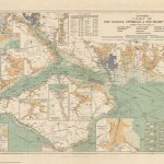
 Stanford`s Map of the Siberian Railway (1904) – A2 Wall Map, Canvas
Stanford`s Map of the Siberian Railway (1904) – A3 Wall Map, Canvas – Print on Demand
Stanford`s Map of the Siberian Railway (1904) – A1 Wall Map, Canvas – Print on Demand
Stanford`s Map of the Siberian Railway (1904) – A2 Wall Map, Canvas
Stanford`s Map of the Siberian Railway (1904) – A3 Wall Map, Canvas – Print on Demand
Stanford`s Map of the Siberian Railway (1904) – A1 Wall Map, Canvas – Print on Demand
 Stanford`s Chart of the Solent, Spithead and Southampton Water (1932) – A1 Wall Map, Canvas
Stanford`s Chart of the Solent, Spithead and Southampton Water (1932) – A2 Wall Map, Canvas
Stanford`s General Map of the World (1920) – XL Size (120 x 80cm) Wall Map, Canvas
Stanford`s Chart of the Solent, Spithead and Southampton Water (1932) – A3 Wall Map, Canvas – Print on Demand
Stanford`s Map of the Siberian Railway (1904) – Original Size Wall Map, Canvas
Stanford`s Chart of the Solent, Spithead and Southampton Water (1932) – Original Size Wall Map, Canvas
Stanford`s Chart of the Solent, Spithead and Southampton Water (1932) – A1 Wall Map, Canvas
Stanford`s Chart of the Solent, Spithead and Southampton Water (1932) – A2 Wall Map, Canvas
Stanford`s General Map of the World (1920) – XL Size (120 x 80cm) Wall Map, Canvas
Stanford`s Chart of the Solent, Spithead and Southampton Water (1932) – A3 Wall Map, Canvas – Print on Demand
Stanford`s Map of the Siberian Railway (1904) – Original Size Wall Map, Canvas
Stanford`s Chart of the Solent, Spithead and Southampton Water (1932) – Original Size Wall Map, Canvas
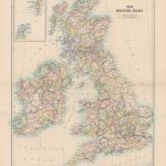
 Stanford`s Folio British Isles Map (1884) – A2 Wall Map, Canvas
Stanford`s Folio British Isles Map (1884) – A4 Wall Map, Canvas
Stanford`s Folio British Isles Map (1884) – A3 Wall Map, Canvas
Stanford`s Folio British Isles Map (1884) – A1 Wall Map, Canvas
Stanford`s Folio British Isles Map (1884) – A2 Wall Map, Canvas
Stanford`s Folio British Isles Map (1884) – A4 Wall Map, Canvas
Stanford`s Folio British Isles Map (1884) – A3 Wall Map, Canvas
Stanford`s Folio British Isles Map (1884) – A1 Wall Map, Canvas
 Stanford`s Folio British Isles Map (1884) – A1 Wall Map, Canvas – Special Edition
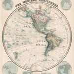 Stanford`s Western Hemisphere Map (1877) – A2 Wall Map, Canvas
 Stanford`s Library Map of the World (1879) – A3 Wall Map, Canvas