Disclosure : This site contains affiliate links to products. We may receive a commission for purchases made through these links.
Stanford`s General Map of the World (1920) – A1 Wall Map, Paper – Print on Demand
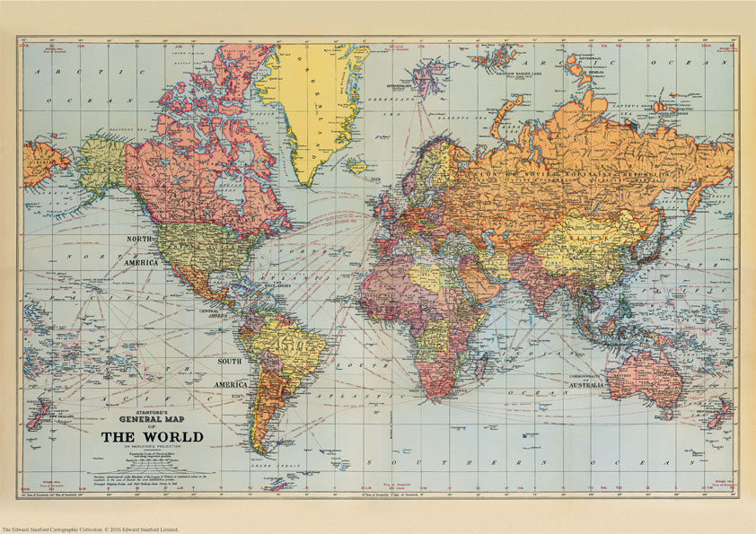
Print on Demand map from the Edward Stanford Cartographic Collection archive.The Stanford’s General Map of the World Map is from a fascinating series of reproductions from our Edward Stanford Cartographic Collection archive.This map from 1920 reflects the changes in political boundaries and the new world order in the aftermath of World War I. The colouring and annotations to place names not only indicate dominions and colonial possessions, with the British Empire in its customary red, but also show territories administered under the Mandate of the League of Nations. On land masses topographic information is provided by names of mountain ranges and of an unusually large number of rivers. Main railway routes are also marked. On seas and oceans, principal shipping routes are shown annotated with distances. The map has latitude and longitude lines at 15 degree intervals and for each longitude line indicates the time difference with the Greenwich Meridian. The map is drawn on a Mercator’s projection.This is the A1 paper version.

Related Products:
 Stanford`s General Map of the World (1920) – A3 Wall Map, Paper
Stanford`s General Map of the World (1920) – A2 Wall Map, Paper
Stanford`s General Map of the World (1920) – A3 Wall Map, Paper
Stanford`s General Map of the World (1920) – A2 Wall Map, Paper
 Stanford`s General Map of the World (1920) – XL Size (120 x 80cm) Wall Map, Paper
Stanford`s General Map of the World (1920) – A3 Wall Map, Canvas
Stanford`s General Map of the World (1920) – A2 Wall Map, Canvas
Stanford`s General Map of the World (1920) – A1 Wall Map, Canvas
Stanford`s General Map of the World (1920) – XL Size (120 x 80cm) Wall Map, Paper
Stanford`s General Map of the World (1920) – A3 Wall Map, Canvas
Stanford`s General Map of the World (1920) – A2 Wall Map, Canvas
Stanford`s General Map of the World (1920) – A1 Wall Map, Canvas
 Stanford`s New Library Chart of the World (1920) – A3 Wall Map, Paper – Print on Demand
Stanford`s New Library Chart of the World (1920) – A2 Wall Map, Paper – Print on Demand
Stanford`s General Map of the World (1920) – XL Size (120 x 80cm) Wall Map, Canvas
Stanford`s New Library Chart of the World (1920) – Original Size Wall Map, Paper – Print on Demand
Stanford`s New Library Chart of the World (1920) – A3 Wall Map, Paper – Print on Demand
Stanford`s New Library Chart of the World (1920) – A2 Wall Map, Paper – Print on Demand
Stanford`s General Map of the World (1920) – XL Size (120 x 80cm) Wall Map, Canvas
Stanford`s New Library Chart of the World (1920) – Original Size Wall Map, Paper – Print on Demand
 Stanford`s Library Map of the World (1879) – A2 Wall Map, Paper – Print on Demand
Stanford`s Library Map of the World (1879) – A1 Wall Map, Paper – Print on Demand
Stanford`s Library Map of the World (1879) – A2 Wall Map, Paper – Print on Demand
Stanford`s Library Map of the World (1879) – A1 Wall Map, Paper – Print on Demand
 Stanford`s New Library Chart of the World (1920) – Original Size Wall Map, Canvas – Print on Demand
 Stanford`s Folio Smaller Railway Map of the United States (1876) – A3 Wall Map, Paper – Print on Demand
Stanford`s Folio Smaller Railway Map of the United States (1876) – A2 Wall Map, Paper – Print on Demand
Stanford`s Folio Smaller Railway Map of the United States (1876) – A3 Wall Map, Paper – Print on Demand
Stanford`s Folio Smaller Railway Map of the United States (1876) – A2 Wall Map, Paper – Print on Demand
 Stanford`s Map of the Siberian Railway (1904) – A2 Wall Map, Paper – Print on Demand
 Stanford`s Library Map of Japan (1879) – A1 Wall Map, Paper – Print on Demand
Stanford`s Map of the Siberian Railway (1904) – A3 Wall Map, Paper – Print on Demand
Stanford`s Map of the Siberian Railway (1904) – A1 Wall Map, Paper – Print on Demand
Stanford`s Library Map of Japan (1879) – A1 Wall Map, Paper – Print on Demand
Stanford`s Map of the Siberian Railway (1904) – A3 Wall Map, Paper – Print on Demand
Stanford`s Map of the Siberian Railway (1904) – A1 Wall Map, Paper – Print on Demand
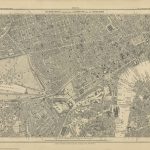
 Stanford`s Map of the British Metropolis: London (1877) – A1 Wall Map, Paper – Print on Demand
 Stanford`s Varty`s Roman Empire Map (1879) – A4 Wall Map, Paper – Print on Demand
Stanford`s Varty`s Roman Empire Map (1879) – A1 Wall Map, Paper – Print on Demand
Stanford`s Varty`s Roman Empire Map (1879) – A4 Wall Map, Paper – Print on Demand
Stanford`s Varty`s Roman Empire Map (1879) – A1 Wall Map, Paper – Print on Demand
 Stanford`s Route Map of the Earth Colour (1854) – A1 Wall Map, Paper – Print on Demand
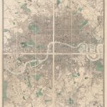 Stanford`s Library Map of London and its Suburbs (1878) – A1 Wall Map, Paper – Print on Demand
Stanford`s Map of the Siberian Railway (1904) – Original Size Wall Map, Paper – Print on Demand
Stanford`s Library Map of London and its Suburbs (1878) – A1 Wall Map, Paper – Print on Demand
Stanford`s Map of the Siberian Railway (1904) – Original Size Wall Map, Paper – Print on Demand
 Stanford`s Facsimile of the Hereford Mappa Mundi (1869) – A3 Wall Map, Paper – Print on Demand
Stanford`s Facsimile of the Hereford Mappa Mundi (1869) – A1 Wall Map, Paper – Print on Demand
Stanford`s Facsimile of the Hereford Mappa Mundi (1869) – A3 Wall Map, Paper – Print on Demand
Stanford`s Facsimile of the Hereford Mappa Mundi (1869) – A1 Wall Map, Paper – Print on Demand
 Stanford`s New Map of Kabul (1880) – A1 Wall Map, Paper – Print on Demand
Stanford`s Folio Smaller Railway Map of the United States (1876) – A2 Wall Map, Canvas – Print on Demand
Stanford`s New Map of Kabul (1880) – A1 Wall Map, Paper – Print on Demand
Stanford`s Folio Smaller Railway Map of the United States (1876) – A2 Wall Map, Canvas – Print on Demand
 Stanford`s Map of the County of London (1888) – A1 Wall Map, Paper – Print on Demand
Stanford`s Map of the Siberian Railway (1904) – A1 Wall Map, Canvas – Print on Demand
Stanford`s Map of the County of London (1888) – A1 Wall Map, Paper – Print on Demand
Stanford`s Map of the Siberian Railway (1904) – A1 Wall Map, Canvas – Print on Demand
 Stanford`s New Two Inch Map of London (1913) – A2 Wall Map, Canvas – Print on Demand
Stanford`s Map of the Siberian Railway (1904) – A3 Wall Map, Canvas – Print on Demand
Stanford`s New Two Inch Map of London (1913) – A2 Wall Map, Canvas – Print on Demand
Stanford`s Map of the Siberian Railway (1904) – A3 Wall Map, Canvas – Print on Demand
 Stanford`s South Polar Chart (1901) – A1 Wall Map, Paper – Print on Demand
 Stanford`s Pacific-centred World Map (1884) – A1 Wall Map, Canvas – Print on Demand
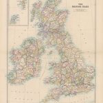
 Stanford`s Folio British Isles Map (1884) – A2 Wall Map, Paper – Print on Demand
 Stanford`s Africa Map (1879) – A2 Wall Map, Paper – Print on Demand
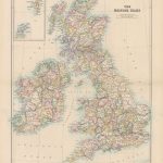
 Stanford`s Folio British Isles Map (1884) – A1 Wall Map, Paper – Special Edition – Print on Demand
 Stanford`s Library Map of South America (1864) – A2 Wall Map, Canvas – Print on Demand
 Stanford`s Library Map of London Sheet 10 Black and White (1862) – A3 Wall Map, Paper – Print on Demand