Disclosure : This site contains affiliate links to products. We may receive a commission for purchases made through these links.
Stanford`s Folio Europe Map, by J. Arrowsmith (1884) – A1 Wall Map, Canvas
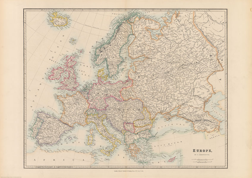
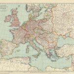
The Stanford’s Europe Map is from a fascinating series of reproductions from our Edward Stanford Cartographic Collection archive.This map was made by the famous cartographer John Arrowsmith and published by Stanfords in 1884.The map presents the continent at the height of its great empires: imperial Russia with Finland and much of Poland, united Germany including Alsace and part of Lorraine, the Austro-Hungarian Empire (although already post the Compromise, still shown here as one country) with north-western Balkans, and the Ottomans still with Albania and much of the present-day Greece.Country boundaries are outlined in bright colours while the pale background with subtle hachuring indicating the mountain ranges are in most places printed very faintly so names of towns and numerous geographical region marked on the map are easy to read. The map also has an unusually large number of names of smaller rivers. Latitude and longitude lines are drawn at 5ยฐ intervals.This is the A1 canvas version.

Related Products:
 Stanford`s Folio Europe Map, by J. Arrowsmith (1884) – A3 Wall Map, Canvas
Stanford`s Folio Europe Map, by J. Arrowsmith (1884) – A2 Wall Map, Canvas
Stanford`s Folio Europe Map, by J. Arrowsmith (1884) – A4 Wall Map, Canvas
Stanford`s Folio Europe Map, by J. Arrowsmith (1884) – A4 Wall Map, Paper
Stanford`s Folio Europe Map, by J. Arrowsmith (1884) – A3 Wall Map, Paper
Stanford`s Folio Europe Map, by J. Arrowsmith (1884) – A2 Wall Map, Paper
Stanford`s Folio Europe Map, by J. Arrowsmith (1884) – A1 Wall Map, Paper
Stanford`s Folio Europe Map, by J. Arrowsmith (1884) – A3 Wall Map, Canvas
Stanford`s Folio Europe Map, by J. Arrowsmith (1884) – A2 Wall Map, Canvas
Stanford`s Folio Europe Map, by J. Arrowsmith (1884) – A4 Wall Map, Canvas
Stanford`s Folio Europe Map, by J. Arrowsmith (1884) – A4 Wall Map, Paper
Stanford`s Folio Europe Map, by J. Arrowsmith (1884) – A3 Wall Map, Paper
Stanford`s Folio Europe Map, by J. Arrowsmith (1884) – A2 Wall Map, Paper
Stanford`s Folio Europe Map, by J. Arrowsmith (1884) – A1 Wall Map, Paper
 Stanford`s Folio Asia Map, by J. Arrowsmith (1884) – A4 Wall Map, Canvas
Stanford`s Folio Asia Map, by J. Arrowsmith (1884) – A3 Wall Map, Canvas
Stanford`s Folio Asia Map, by J. Arrowsmith (1884) – A2 Wall Map, Canvas
Stanford`s Folio Asia Map, by J. Arrowsmith (1884) – A1 Wall Map, Canvas
Stanford`s Folio Asia Map, by J. Arrowsmith (1884) – A3 Wall Map, Paper
Stanford`s Folio Asia Map, by J. Arrowsmith (1884) – A2 Wall Map, Paper
Stanford`s Folio Asia Map, by J. Arrowsmith (1884) – A1 Wall Map, Paper
Stanford`s Folio Asia Map, by J. Arrowsmith (1884) – A4 Wall Map, Canvas
Stanford`s Folio Asia Map, by J. Arrowsmith (1884) – A3 Wall Map, Canvas
Stanford`s Folio Asia Map, by J. Arrowsmith (1884) – A2 Wall Map, Canvas
Stanford`s Folio Asia Map, by J. Arrowsmith (1884) – A1 Wall Map, Canvas
Stanford`s Folio Asia Map, by J. Arrowsmith (1884) – A3 Wall Map, Paper
Stanford`s Folio Asia Map, by J. Arrowsmith (1884) – A2 Wall Map, Paper
Stanford`s Folio Asia Map, by J. Arrowsmith (1884) – A1 Wall Map, Paper
 Stanford`s Folio North America Map (1884) – A4 Wall Map, Canvas
Stanford`s Folio North America Map (1884) – A3 Wall Map, Canvas
Stanford`s Folio North America Map (1884) – A2 Wall Map, Canvas
Stanford`s Folio North America Map (1884) – A4 Wall Map, Canvas
Stanford`s Folio North America Map (1884) – A3 Wall Map, Canvas
Stanford`s Folio North America Map (1884) – A2 Wall Map, Canvas
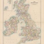
 Stanford`s Folio British Isles Map (1884) – A2 Wall Map, Canvas
Stanford`s Folio British Isles Map (1884) – A4 Wall Map, Canvas
Stanford`s Folio British Isles Map (1884) – A3 Wall Map, Canvas
Stanford`s Folio British Isles Map (1884) – A1 Wall Map, Canvas
Stanford`s Folio British Isles Map (1884) – A2 Wall Map, Canvas
Stanford`s Folio British Isles Map (1884) – A4 Wall Map, Canvas
Stanford`s Folio British Isles Map (1884) – A3 Wall Map, Canvas
Stanford`s Folio British Isles Map (1884) – A1 Wall Map, Canvas
 Stanford`s Folio British Isles Map (1884) – A1 Wall Map, Canvas – Special Edition
Stanford`s Folio North America Map (1884) – A3 Wall Map, Paper
Stanford`s Folio North America Map (1884) – A2 Wall Map, Paper
Stanford`s Folio North America Map (1884) – A1 Wall Map, Paper
Stanford`s Folio British Isles Map (1884) – A4 Wall Map, Paper
Stanford`s Folio British Isles Map (1884) – A3 Wall Map, Paper
Stanford`s Folio British Isles Map (1884) – A1 Wall Map, Paper
Stanford`s Folio British Isles Map (1884) – A2 Wall Map, Paper – Print on Demand
Stanford`s Folio British Isles Map (1884) – A1 Wall Map, Canvas – Special Edition
Stanford`s Folio North America Map (1884) – A3 Wall Map, Paper
Stanford`s Folio North America Map (1884) – A2 Wall Map, Paper
Stanford`s Folio North America Map (1884) – A1 Wall Map, Paper
Stanford`s Folio British Isles Map (1884) – A4 Wall Map, Paper
Stanford`s Folio British Isles Map (1884) – A3 Wall Map, Paper
Stanford`s Folio British Isles Map (1884) – A1 Wall Map, Paper
Stanford`s Folio British Isles Map (1884) – A2 Wall Map, Paper – Print on Demand
 Stanford`s Folio British Isles Map (1884) – A1 Wall Map, Paper – Special Edition – Print on Demand
 Stanford`s Folio Japan Map (1884) – A3 Wall Map, Canvas
Stanford`s Folio Japan Map (1884) – A2 Wall Map, Canvas
Stanford`s Folio Japan Map (1884) – A1 Wall Map, Canvas
Stanford`s Folio Japan Map (1884) – A3 Wall Map, Canvas
Stanford`s Folio Japan Map (1884) – A2 Wall Map, Canvas
Stanford`s Folio Japan Map (1884) – A1 Wall Map, Canvas
 Stanford`s Pacific-centred World Map (1884) – Original Size Wall Map, Canvas
 Europe: Stanfords Map of Europe in 1884 SMALL
Stanford`s Folio Japan Map (1884) – A3 Wall Map, Paper
Stanford`s Folio Japan Map (1884) – A2 Wall Map, Paper
Stanford`s Folio Japan Map (1884) – A1 Wall Map, Paper
Europe: Stanfords Map of Europe in 1884 SMALL
Stanford`s Folio Japan Map (1884) – A3 Wall Map, Paper
Stanford`s Folio Japan Map (1884) – A2 Wall Map, Paper
Stanford`s Folio Japan Map (1884) – A1 Wall Map, Paper
 Stanford`s Tourists` Map of Europe (1928) – A2 Wall Map, Canvas