Disclosure : This site contains affiliate links to products. We may receive a commission for purchases made through these links.
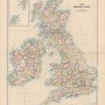
Stanford`s Folio British Isles Map (1884) – A1 Wall Map, Paper – Special Edition – Print on Demand
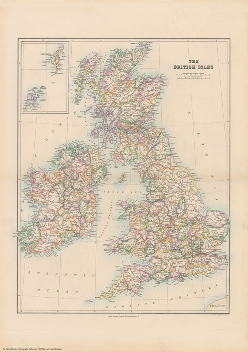
Print on Demand map from the Edward Stanford Cartographic Collection archive.A special edition of The Stanford’s British Isles Map from a fascinating series of reproductions from our Edward Stanford Cartographic Collection archive.Published in 1884, this map shows the British Isles with their old historic counties. Bright colours highlight the boundaries of the old counties as they were. The pale background makes all the place names easy to read. In common with other maps published by Stanfords at that time, an unusually large number of small rivers are named, even the lovely Cuckmere is there.Ironically perhaps, the map provides an interesting contrast between the significant administrative changes within Great Britain and the retention of the county borders within Ireland. This map includes lots more interesting historical finds, for example; London looks significantly smaller than it does on maps today mostly falling within the county of Middlesex.This is a great map that beautifully tells this history of counties.This is the special edition A1 paper version.

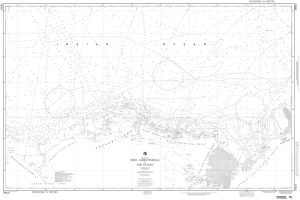
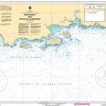
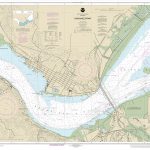
Related Products:
 Stanford`s Folio British Isles Map (1884) – A2 Wall Map, Paper – Print on Demand
Stanford`s Folio British Isles Map (1884) – A4 Wall Map, Paper
Stanford`s Folio British Isles Map (1884) – A3 Wall Map, Paper
Stanford`s Folio British Isles Map (1884) – A1 Wall Map, Paper
Stanford`s Folio British Isles Map (1884) – A2 Wall Map, Canvas
Stanford`s Folio British Isles Map (1884) – A4 Wall Map, Canvas
Stanford`s Folio British Isles Map (1884) – A3 Wall Map, Canvas
Stanford`s Folio British Isles Map (1884) – A1 Wall Map, Canvas
Stanford`s Folio British Isles Map (1884) – A2 Wall Map, Paper – Print on Demand
Stanford`s Folio British Isles Map (1884) – A4 Wall Map, Paper
Stanford`s Folio British Isles Map (1884) – A3 Wall Map, Paper
Stanford`s Folio British Isles Map (1884) – A1 Wall Map, Paper
Stanford`s Folio British Isles Map (1884) – A2 Wall Map, Canvas
Stanford`s Folio British Isles Map (1884) – A4 Wall Map, Canvas
Stanford`s Folio British Isles Map (1884) – A3 Wall Map, Canvas
Stanford`s Folio British Isles Map (1884) – A1 Wall Map, Canvas
 Stanford`s Folio British Isles Map (1884) – A1 Wall Map, Canvas – Special Edition
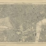
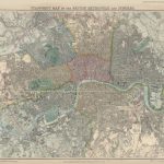 Stanford`s Map of the British Metropolis: London (1877) – A1 Wall Map, Paper – Print on Demand
 Stanford`s Folio Smaller Railway Map of the United States (1876) – A3 Wall Map, Paper – Print on Demand
Stanford`s Folio Smaller Railway Map of the United States (1876) – A2 Wall Map, Paper – Print on Demand
Stanford`s Folio Smaller Railway Map of the United States (1876) – A3 Wall Map, Paper – Print on Demand
Stanford`s Folio Smaller Railway Map of the United States (1876) – A2 Wall Map, Paper – Print on Demand
 Stanford`s New Library Chart of the World (1920) – A3 Wall Map, Paper – Print on Demand
Stanford`s New Library Chart of the World (1920) – A2 Wall Map, Paper – Print on Demand
Stanford`s New Library Chart of the World (1920) – Original Size Wall Map, Paper – Print on Demand
Stanford`s New Library Chart of the World (1920) – A3 Wall Map, Paper – Print on Demand
Stanford`s New Library Chart of the World (1920) – A2 Wall Map, Paper – Print on Demand
Stanford`s New Library Chart of the World (1920) – Original Size Wall Map, Paper – Print on Demand
 Stanford`s Library Map of Japan (1879) – A1 Wall Map, Paper – Print on Demand
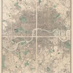
 Stanford`s Map of the County of London (1888) – A1 Wall Map, Paper – Print on Demand
 Stanford`s Varty`s Roman Empire Map (1879) – A4 Wall Map, Paper – Print on Demand
Stanford`s Varty`s Roman Empire Map (1879) – A1 Wall Map, Paper – Print on Demand
Stanford`s Varty`s Roman Empire Map (1879) – A4 Wall Map, Paper – Print on Demand
Stanford`s Varty`s Roman Empire Map (1879) – A1 Wall Map, Paper – Print on Demand
 Stanford`s Route Map of the Earth Colour (1854) – A1 Wall Map, Paper – Print on Demand
 Stanford`s Library Map of London and its Suburbs (1878) – A1 Wall Map, Paper – Print on Demand
 Stanford`s Pacific-centred World Map (1884) – A1 Wall Map, Canvas – Print on Demand
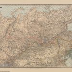 Stanford`s Map of the Siberian Railway (1904) – A3 Wall Map, Paper – Print on Demand
Stanford`s Map of the Siberian Railway (1904) – A1 Wall Map, Paper – Print on Demand
Stanford`s Folio Smaller Railway Map of the United States (1876) – A2 Wall Map, Canvas – Print on Demand
Stanford`s Map of the Siberian Railway (1904) – A2 Wall Map, Paper – Print on Demand
Stanford`s Map of the Siberian Railway (1904) – A3 Wall Map, Paper – Print on Demand
Stanford`s Map of the Siberian Railway (1904) – A1 Wall Map, Paper – Print on Demand
Stanford`s Folio Smaller Railway Map of the United States (1876) – A2 Wall Map, Canvas – Print on Demand
Stanford`s Map of the Siberian Railway (1904) – A2 Wall Map, Paper – Print on Demand
 Stanford`s Facsimile of the Hereford Mappa Mundi (1869) – A3 Wall Map, Paper – Print on Demand
Stanford`s Facsimile of the Hereford Mappa Mundi (1869) – A1 Wall Map, Paper – Print on Demand
Stanford`s Facsimile of the Hereford Mappa Mundi (1869) – A3 Wall Map, Paper – Print on Demand
Stanford`s Facsimile of the Hereford Mappa Mundi (1869) – A1 Wall Map, Paper – Print on Demand
 Stanford`s New Map of Kabul (1880) – A1 Wall Map, Paper – Print on Demand
 Stanford`s South Polar Chart (1901) – A1 Wall Map, Paper – Print on Demand
Stanford`s Map of the Siberian Railway (1904) – Original Size Wall Map, Paper – Print on Demand
Stanford`s South Polar Chart (1901) – A1 Wall Map, Paper – Print on Demand
Stanford`s Map of the Siberian Railway (1904) – Original Size Wall Map, Paper – Print on Demand
 Stanford`s New Library Chart of the World (1920) – Original Size Wall Map, Canvas – Print on Demand
 British Isles: Stanfords Map of the British Isles c.1859 SMALL
 Stanford`s New Two Inch Map of London (1913) – A2 Wall Map, Canvas – Print on Demand
 Stanford`s General Map of the World (1920) – A1 Wall Map, Paper – Print on Demand
 Stanford`s Library Map of London Sheet 10 Black and White (1862) – A3 Wall Map, Paper – Print on Demand
 Stanford`s Chart of the Solent, Spithead and Southampton Water (1932) – A3 Wall Map, Paper – Print on Demand
Stanford`s Chart of the Solent, Spithead and Southampton Water (1932) – A2 Wall Map, Paper – Print on Demand
Stanford`s Chart of the Solent, Spithead and Southampton Water (1932) – A1 Wall Map, Paper – Print on Demand
Stanford`s Chart of the Solent, Spithead and Southampton Water (1932) – A3 Wall Map, Paper – Print on Demand
Stanford`s Chart of the Solent, Spithead and Southampton Water (1932) – A2 Wall Map, Paper – Print on Demand
Stanford`s Chart of the Solent, Spithead and Southampton Water (1932) – A1 Wall Map, Paper – Print on Demand