Disclosure : This site contains affiliate links to products. We may receive a commission for purchases made through these links.
Stanford`s Eastern and Western Hemispheres Map (1877) – A1 Wall Map, Paper
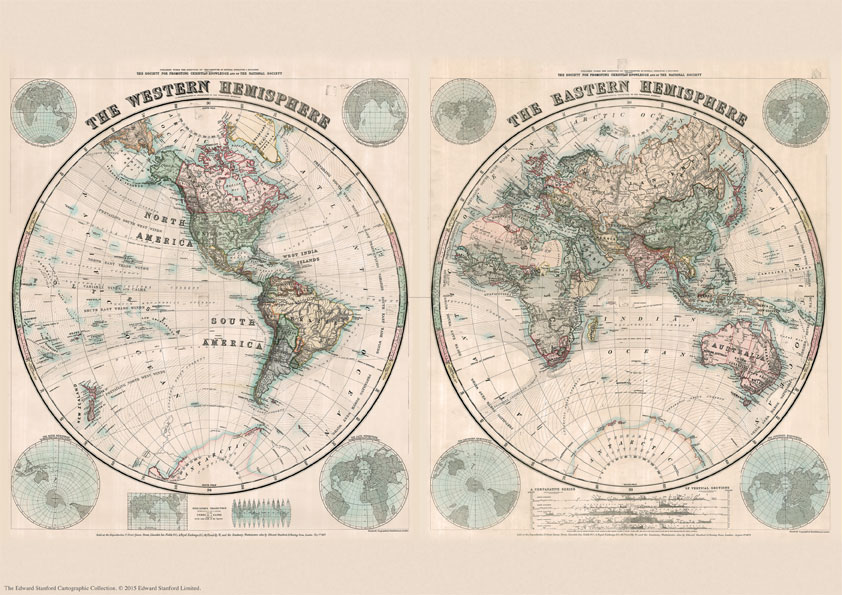
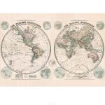
The Stanford’s Map of The Western and Eastern Hemispheres is from a fascinating series of reproductions from our Edward Stanford Cartographic Collection archive.The original map from 1877 was drawn by Stanford’s Geographical Establishment and ‘published under the direction of the Committee of General Literature and Education Appointed by The Society for Promoting Christian Knowledge and of the National Society”. Individual countries are presented in gentle pastel hues, typical of hand-coloured maps, with their borders outlined in stronger colours. The publication date of 1877 gives us the Americas more or less as we know it now but Antarctica with only a handful of coastal places named and believed to be flat. On the eastern side we see a Europe of large imperial states, much of Asia is as we know it, but Africa is still in the early stages of colonization with its interior largely unexplored. The stereographic projection, individual countries are presented in gentle pastel hues typical of hand-coloured maps, with their borders outlined in stronger colours. Latitude and longitude lines are drawn at 10ยฐ intervals. Hachures are used to show the mountain ranges and many other features of contemporary cartography are included: ocean currents and trade winds, surrounding frames showing the tropical zones and the position of the sun, etc. Additional panels on the side of the Western Hemisphere give examples of six different map projections, including Mercator’s projection and the gores of a globe complete on the same scale at the equator.On the side of the Eastern Hemisphere you can see additional panels of the continents as viewed from the two poles as well as a comparative series of vertical cross-sections showing the principle elevations of each continent on their respective parallels of latitude. This is the A1 paper version.PLEASE NOTE: the eastern and western hemispheres are available separately in portrait format on paper or canvas in a variety of sizes.

Related Products:
 Stanford`s Eastern and Western Hemispheres Map (1877) – A3 Wall Map, Paper
Stanford`s Eastern and Western Hemispheres Map (1877) – A2 Wall Map, Paper
Stanford`s Eastern and Western Hemispheres Map (1877) – Original Size Wall Map, Paper
Stanford`s Eastern and Western Hemispheres Map (1877) – A3 Wall Map, Canvas
Stanford`s Eastern and Western Hemispheres Map (1877) – A2 Wall Map, Canvas
Stanford`s Eastern and Western Hemispheres Map (1877) – A1 Wall Map, Canvas
Stanford`s Eastern and Western Hemispheres Map (1877) – Original Size Wall Map, Canvas
Stanford`s Eastern and Western Hemispheres Map (1877) – A3 Wall Map, Paper
Stanford`s Eastern and Western Hemispheres Map (1877) – A2 Wall Map, Paper
Stanford`s Eastern and Western Hemispheres Map (1877) – Original Size Wall Map, Paper
Stanford`s Eastern and Western Hemispheres Map (1877) – A3 Wall Map, Canvas
Stanford`s Eastern and Western Hemispheres Map (1877) – A2 Wall Map, Canvas
Stanford`s Eastern and Western Hemispheres Map (1877) – A1 Wall Map, Canvas
Stanford`s Eastern and Western Hemispheres Map (1877) – Original Size Wall Map, Canvas
 Stanford`s Western Hemisphere Map (1877) – A3 Wall Map, Paper
Stanford`s Western Hemisphere Map (1877) – A2 Wall Map, Paper
Stanford`s Western Hemisphere Map (1877) – A1 Wall Map, Paper – Print on Demand
Stanford`s Western Hemisphere Map (1877) – Original Size Wall Map, Paper
Stanford`s Western Hemisphere Map (1877) – A3 Wall Map, Paper
Stanford`s Western Hemisphere Map (1877) – A2 Wall Map, Paper
Stanford`s Western Hemisphere Map (1877) – A1 Wall Map, Paper – Print on Demand
Stanford`s Western Hemisphere Map (1877) – Original Size Wall Map, Paper
 Stanford`s Eastern Hemisphere Map (1877) – A3 Wall Map, Paper
Stanford`s Eastern Hemisphere Map (1877) – A2 Wall Map, Paper
Stanford`s Eastern Hemisphere Map (1877) – A3 Wall Map, Paper
Stanford`s Eastern Hemisphere Map (1877) – A2 Wall Map, Paper
 A5 Postcard – Stanford`s Eastern and Western Hemispheres Map
Stanford`s Eastern Hemisphere Map (1877) – A1 Wall Map, Paper – Print on Demand
Stanford`s Eastern Hemisphere Map (1877) – Original Size Wall Map, Paper
Stanford`s Western Hemisphere Map (1877) – A2 Wall Map, Canvas
Stanford`s Western Hemisphere Map (1877) – Original Size Wall Map, Canvas
Stanford`s Western Hemisphere Map (1877) – A1 Wall Map, Canvas
Stanford`s Eastern Hemisphere Map (1877) – A3 Wall Map, Canvas
Stanford`s Eastern Hemisphere Map (1877) – A2 Wall Map, Canvas
Stanford`s Eastern Hemisphere Map (1877) – A1 Wall Map, Canvas
Stanford`s Eastern Hemisphere Map (1877) – Original Size Wall Map, Canvas
A5 Postcard – Stanford`s Eastern and Western Hemispheres Map
Stanford`s Eastern Hemisphere Map (1877) – A1 Wall Map, Paper – Print on Demand
Stanford`s Eastern Hemisphere Map (1877) – Original Size Wall Map, Paper
Stanford`s Western Hemisphere Map (1877) – A2 Wall Map, Canvas
Stanford`s Western Hemisphere Map (1877) – Original Size Wall Map, Canvas
Stanford`s Western Hemisphere Map (1877) – A1 Wall Map, Canvas
Stanford`s Eastern Hemisphere Map (1877) – A3 Wall Map, Canvas
Stanford`s Eastern Hemisphere Map (1877) – A2 Wall Map, Canvas
Stanford`s Eastern Hemisphere Map (1877) – A1 Wall Map, Canvas
Stanford`s Eastern Hemisphere Map (1877) – Original Size Wall Map, Canvas
 Stanfords Western Hemisphere Wall Map c.1877 LARGE
 Western Hemisphere: Stanfords Map from 1877 SMALL
 Stanford`s Pacific-centred World Map (1884) – Original Size Wall Map, Paper
 Eastern Hemisphere: Stanfords Map from 1877 SMALL
Stanford`s Pacific-centred World Map (1884) – Original Size Wall Map, Canvas
Eastern Hemisphere: Stanfords Map from 1877 SMALL
Stanford`s Pacific-centred World Map (1884) – Original Size Wall Map, Canvas
 North Polar Chart 1902 SMALL
North Polar Chart 1902 MEDIUM
North Polar Chart 1902 SMALL
North Polar Chart 1902 MEDIUM
 Stanford`s Library Map of the World (1879) – A3 Wall Map, Paper
Stanford`s Library Map of the World (1879) – A2 Wall Map, Paper – Print on Demand
Stanford`s Library Map of the World (1879) – A1 Wall Map, Paper – Print on Demand
Stanford`s Library Map of the World (1879) – A3 Wall Map, Paper
Stanford`s Library Map of the World (1879) – A2 Wall Map, Paper – Print on Demand
Stanford`s Library Map of the World (1879) – A1 Wall Map, Paper – Print on Demand
 Map of Discovery – Western Hemisphere NGS Wall Map PAPER
 Map of Discovery – Eastern Hemisphere NGS Wall Map PAPER
 Stanford`s Library Map of the World (1879) – Original Size Wall Map, Paper
 Stanford`s Map of the British Metropolis: London (1877) – A2 Wall Map, Paper
Stanford`s Map of the British Metropolis: London (1877) – A3 Wall Map, Paper
Stanford`s Map of the British Metropolis: London (1877) – A1 Wall Map, Paper – Print on Demand
Stanford`s Map of the British Metropolis: London (1877) – A2 Wall Map, Paper
Stanford`s Map of the British Metropolis: London (1877) – A3 Wall Map, Paper
Stanford`s Map of the British Metropolis: London (1877) – A1 Wall Map, Paper – Print on Demand
 Stanfords Eastern and Western Hemispheres Map (1887) 60x80cm Art Print