Disclosure : This site contains affiliate links to products. We may receive a commission for purchases made through these links.
Stanford`s Africa Map (1879) – A1 Wall Map, Canvas
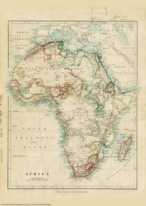
Reproduction of a very interesting map of Africa published by our founder Edward Stanford in 1879 and showing the continent in the relatively early stages of its colonization. The information marked on the map forms a fascinating mixture of names of towns, countries or colonial possessions, geographical regions or features such as deserts, and of many African tribes. Although the map has no physical colouring, it instantly conveys much information about the continent’s geography through the distribution of the already explored regions with established administrative entities. The bulk of the coastline is already in colour and various political units are shown in the more accessible Sahel belt, from the Atlantic along the Niger and around Lake Chad to Darfur and northern Ethiopia. However, the Sahara and the great expanse of the continent around the Congo (called here Livingstone River) and further south and east are yet to be colonized. Although, in many places, particular in East Africa, various geographical features are already marked on the map.Latitude and longitude lines are drawn at 10ยฐ intervals. Of all the continents, Africa has undergone most changes from the mid 19th century to the present day and this map provides an early step towards understanding its history. This is the A1 canvas version.

Related Products:
 Stanford`s Africa Map (1879) – A3 Wall Map, Canvas
Stanford`s Africa Map (1879) – A2 Wall Map, Canvas
Stanford`s Africa Map (1879) – A3 Wall Map, Paper
Stanford`s Africa Map (1879) – A1 Wall Map, Paper
Stanford`s Africa Map (1879) – A2 Wall Map, Paper – Print on Demand
Stanford`s Africa Map (1879) – A3 Wall Map, Canvas
Stanford`s Africa Map (1879) – A2 Wall Map, Canvas
Stanford`s Africa Map (1879) – A3 Wall Map, Paper
Stanford`s Africa Map (1879) – A1 Wall Map, Paper
Stanford`s Africa Map (1879) – A2 Wall Map, Paper – Print on Demand
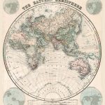
 Stanford`s Library Map of the World (1879) – A3 Wall Map, Canvas
Stanford`s Library Map of the World (1879) – A2 Wall Map, Canvas
Stanford`s Library Map of the World (1879) – A1 Wall Map, Canvas
Stanford`s Library Map of the World (1879) – A3 Wall Map, Canvas
Stanford`s Library Map of the World (1879) – A2 Wall Map, Canvas
Stanford`s Library Map of the World (1879) – A1 Wall Map, Canvas
 Stanford`s Library Map of the World (1879) – Original Size Wall Map, Canvas
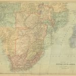 Stanford`s Map of British South Africa (1894) – A3 Wall Map, Canvas
Stanford`s Map of British South Africa (1894) – A2 Wall Map, Canvas
Stanford`s Map of British South Africa (1894) – A1 Wall Map, Canvas
Stanford`s Map of British South Africa (1894) – A3 Wall Map, Canvas
Stanford`s Map of British South Africa (1894) – A2 Wall Map, Canvas
Stanford`s Map of British South Africa (1894) – A1 Wall Map, Canvas
 Stanford`s Library Map of Africa (1890) – A3 Wall Map, Canvas
Stanford`s Library Map of Africa (1890) – A2 Wall Map, Canvas
Stanford`s Library Map of Africa (1890) – A1 Wall Map, Canvas
Stanford`s Library Map of the World (1879) – A3 Wall Map, Paper
Stanford`s Library Map of Africa (1890) – A3 Wall Map, Canvas
Stanford`s Library Map of Africa (1890) – A2 Wall Map, Canvas
Stanford`s Library Map of Africa (1890) – A1 Wall Map, Canvas
Stanford`s Library Map of the World (1879) – A3 Wall Map, Paper
 Stanford`s Library Map of the World (1879) – Original Size Wall Map, Paper
Stanford`s Library Map of the World (1879) – A2 Wall Map, Paper – Print on Demand
Stanford`s Library Map of the World (1879) – A1 Wall Map, Paper – Print on Demand
Stanford`s Map of British South Africa (1894) – A3 Wall Map, Paper
Stanford`s Map of British South Africa (1894) – A2 Wall Map, Paper
Stanford`s Map of British South Africa (1894) – A1 Wall Map, Paper
Stanford`s Library Map of the World (1879) – Original Size Wall Map, Paper
Stanford`s Library Map of the World (1879) – A2 Wall Map, Paper – Print on Demand
Stanford`s Library Map of the World (1879) – A1 Wall Map, Paper – Print on Demand
Stanford`s Map of British South Africa (1894) – A3 Wall Map, Paper
Stanford`s Map of British South Africa (1894) – A2 Wall Map, Paper
Stanford`s Map of British South Africa (1894) – A1 Wall Map, Paper
 Stanford`s Pacific-centred World Map (1884) – A4 Wall Map, Canvas
Stanford`s Pacific-centred World Map (1884) – A3 Wall Map, Canvas
Stanford`s Pacific-centred World Map (1884) – A2 Wall Map, Canvas
Stanford`s Pacific-centred World Map (1884) – A4 Wall Map, Canvas
Stanford`s Pacific-centred World Map (1884) – A3 Wall Map, Canvas
Stanford`s Pacific-centred World Map (1884) – A2 Wall Map, Canvas
 Stanford`s Library Map of Japan (1879) – A3 Wall Map, Canvas
Stanford`s Library Map of Japan (1879) – A2 Wall Map, Canvas
Stanford`s Library Map of Japan (1879) – A1 Wall Map, Canvas
Stanford`s Library Map of Japan (1879) – A3 Wall Map, Canvas
Stanford`s Library Map of Japan (1879) – A2 Wall Map, Canvas
Stanford`s Library Map of Japan (1879) – A1 Wall Map, Canvas
 South Africa De Long Wine Wall Map
 Stanford`s Varty`s Roman Empire Map (1879) – A3 Wall Map, Canvas
Stanford`s Varty`s Roman Empire Map (1879) – A2 Wall Map, Canvas
Stanford`s Varty`s Roman Empire Map (1879) – A1 Wall Map, Canvas
Stanford`s Varty`s Roman Empire Map (1879) – A3 Wall Map, Canvas
Stanford`s Varty`s Roman Empire Map (1879) – A2 Wall Map, Canvas
Stanford`s Varty`s Roman Empire Map (1879) – A1 Wall Map, Canvas
 Stanford`s Eastern Hemisphere Map (1877) – A3 Wall Map, Canvas
Stanford`s Eastern Hemisphere Map (1877) – A2 Wall Map, Canvas
Stanford`s Eastern Hemisphere Map (1877) – A1 Wall Map, Canvas
Stanford`s Library Map of Japan (1879) – Original Size Wall Map, Canvas
Stanford`s Pacific-centred World Map (1884) – A1 Wall Map, Canvas – Print on Demand
Stanford`s Eastern Hemisphere Map (1877) – A3 Wall Map, Canvas
Stanford`s Eastern Hemisphere Map (1877) – A2 Wall Map, Canvas
Stanford`s Eastern Hemisphere Map (1877) – A1 Wall Map, Canvas
Stanford`s Library Map of Japan (1879) – Original Size Wall Map, Canvas
Stanford`s Pacific-centred World Map (1884) – A1 Wall Map, Canvas – Print on Demand
 Stanford`s Folio Asia Map, by J. Arrowsmith (1884) – A4 Wall Map, Canvas
Stanford`s Folio Asia Map, by J. Arrowsmith (1884) – A3 Wall Map, Canvas
Stanford`s Folio Asia Map, by J. Arrowsmith (1884) – A2 Wall Map, Canvas
Stanford`s Folio Asia Map, by J. Arrowsmith (1884) – A4 Wall Map, Canvas
Stanford`s Folio Asia Map, by J. Arrowsmith (1884) – A3 Wall Map, Canvas
Stanford`s Folio Asia Map, by J. Arrowsmith (1884) – A2 Wall Map, Canvas