Disclosure : This site contains affiliate links to products. We may receive a commission for purchases made through these links.
Stajerska – Slovene Hills – Haloze – Boc Kartografija Tourist Map
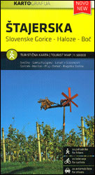
Stajerska region of north-eastern Slovenia on a contoured and GPS compatible map at 1:50,000 from the Ljubljana-based Kartografija, with coverage centred on Ptuj and including Maribor on the western edge of the map. On the reverse are bilingual English/Slovenian descriptions of the region’s best sights.Maps in this series from Kartografija, covering Slovenia at 50K or 75K, have contours at 20m intervals, enhanced by relief shading and plenty of spot heights, names of peaks, mountain chains, etc. Local hiking routes are highlighted and also marked are recommended cycling routes. Symbols indicate various types of accommodation including mountain huts, campsites, inns with lodgings, tourist farms or apartments, hotels and motels, as well as recreational facilities (golf, horse riding, swimming pools, etc), vineries, cultural and historical sites, etc. Road network shows locations of petrol stations. Railway lines are shown with stations and various types of mountain transport (gondolas, chair lifts, etc) are marked. The maps have a latitude and longitude grid at intervals of 2’30’’. The reverse side is covered by bilingual notes on the area’s places of interest. Map legend and all the text include English. To see other titles in this series please click on the series link.

Related Products:
 Primorska Kartografija Tourist Map
 Posavsko Hribovje Kartografija Tourist Map
 Ljubljana and Environs Kartografija Tourist Map
 Julian Alps West Kartografija Tourist Map
 Notranjski Kras – Brkini – Dolenjska – Bela Krajina Kartografija Tourist Map
 Slovenia: Kartografija 75K Hiking Maps
 Slovenia: Kartografija 40K Hiking and Cycling Sets
 Triglav National Park Kartografija WATERPROOF Hiking Map
 Karavanke Mountains – Kep to Kosuta Kartografija WATERPROOF Hiking Map
 Slovenia Kartografija Road Atlas
 Triglav Kartografija WATERPROOF Hiking Map
 Carpathians Kartografija Tourist Map ENGLISH
 Kamnik and Savinja Alps Kartografija WATERPROOF Hiking Map
 Slovenia Kartografija Top 15 Guide
 Slovenia: Kartografija 50K/25K Hiking Maps
 Kiev Kartografija Street Plan
 Koszeg Hills Cartographia Tourist Map 13
 Gemenc – Szekszard-Hills Tourist Map
 Buda Hills Cartographia Tourist Map 6
 Zemplen Hills North Cartographia Tourist Map 22
Pilis – Visegrad Hills Cartographia Tourist Map 16
Zemplen Hills North Cartographia Tourist Map 22
Pilis – Visegrad Hills Cartographia Tourist Map 16
 Zemplen Hills South Cartographia Tourist Map 23
 Bohinj Kartografija WATERPROOF Hiking Map
 Ukraine Kartografija Road Atlas 500K HARDBACK
 Ukraine: Kartografija 500K Road Maps
 Gorenjska
 Primorska – Trieste
 Pohorje
Skofjelosko – Idrijsko – Cerkljansko Hribovje
Pohorje
Skofjelosko – Idrijsko – Cerkljansko Hribovje
 Julian Alps Kartografija WATERPROOF Hiking Map
 Julian Alps
 Ukraine: Kartografija`s 250K Maps of the Administrative Regions
 Kranjska Gora Kartografija WATERPROOF Hiking Map
Pomurje
Posocje
Kranjska Gora Kartografija WATERPROOF Hiking Map
Pomurje
Posocje
 Lviv Kartografija Street Plan
 Yalta Kartografija Street Plan
Ljubljana and Environs
Yalta Kartografija Street Plan
Ljubljana and Environs
 Brasov Region Tourist Map