Disclosure : This site contains affiliate links to products. We may receive a commission for purchases made through these links.
St Ives 1906
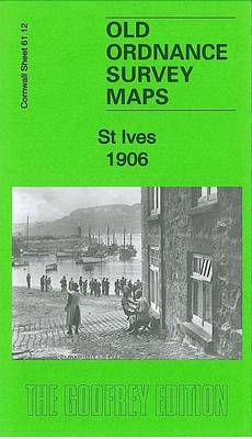
St Ives in 1906 in a fascinating series of reproductions of old Ordnance Survey plans in the Alan Godfrey Editions, ideal for anyone interested in the history of their neighbourhood or family. The map covers most of St Ives and includes sheet 61.12 and part of sheet 61.11, so extending coverage westward to Hellesveor and Hellesvean. Features include the town centre, railway station, Stennack, Ayr, harbour, Porthminster Beach, Tregenna Castle Hotel, St Nicholas chapel remains, St Andrew`s church, Porthminster Point, Bamaluz Point, Wheal Trenwith, Wheal Ayr, Bahavella, Porthmeor Beach, Carrick Du, Penbeagle, Hellesvean, St John`s church etc,. Extracts from a 1910 directory are included on the reverse. About the Alan Godfrey Editions of the 25″ OS SeriesSelected towns in Great Britain and Ireland are covered by maps showing the extent of urban development in the last decades of the 19th and early 20th century. The plans have been taken from the Ordnance Survey mapping and reprinted at about 15 inches to one mile (1:4,340). On the reverse most maps have historical notes and many also include extracts from contemporary directories. Most maps cover about one mile (1.6kms) north/south, one and a half miles (2.4kms) across; adjoining sheets can be combined to provide wider coverage.FOR MORE INFORMATION AND A COMPLETE LIST OF ALL AVAILABLE TITLES PLEASE CLICK ON THE SERIES LINK.

Related Products:
 Penzance and St Ives Bay 1888
Redruth 1906
Penzance and St Ives Bay 1888
Redruth 1906
 Whitstable (North) 1906 – 23.10
 Whitstable East 1906
Helston 1906
Whitstable East 1906
Helston 1906
 Newton-le-Willows 1906
Hindley Green 1906
Canterbury 1906 – 46.03
Bodmin 1906
Newton-le-Willows 1906
Hindley Green 1906
Canterbury 1906 – 46.03
Bodmin 1906
 Rainhill 1906
Penryn 1906
Wadebridge 1906
Rainhill 1906
Penryn 1906
Wadebridge 1906
 Meanwood and Far Headingley 1906
 Kirkdale 1906
 Knotty Ash and Old Swan 1906
Hurst and North Ashton 1906
Knotty Ash and Old Swan 1906
Hurst and North Ashton 1906
 Peebles 1906 – 13.06
 Central Leeds 1906 – 218.02b
Church Stretton and Wenlock Edge 1906
Central Leeds 1906 – 218.02b
Church Stretton and Wenlock Edge 1906
 Central Liverpool 1906 – 106.14b
 Bradford East 1906
 Liverpool North 1906
Looe 1905
Liverpool North 1906
Looe 1905
 Leeds South and South East 1906
 Thornton Cleveleys 1910
Dundonald 1902
Earlestown South 1906
Thornton Cleveleys 1910
Dundonald 1902
Earlestown South 1906
 Upper Batley 1906
 Liverpool Toxteth 1906
 Leeds East 1906
Bamfurlong and Bryn Gates 1906
Leeds East 1906
Bamfurlong and Bryn Gates 1906
 Bradford Central 1906
 Walton on the Hill 1906
Aintree 1906
Rock Ferry and New Ferry 1898
Walton on the Hill 1906
Aintree 1906
Rock Ferry and New Ferry 1898
 Farnham 1913
Leadgate 1895 – 11.11a
New Quay 1904
Swanage 1900
Crickhowell & Llangattock 1903
Farnham 1913
Leadgate 1895 – 11.11a
New Quay 1904
Swanage 1900
Crickhowell & Llangattock 1903