Disclosure : This site contains affiliate links to products. We may receive a commission for purchases made through these links.
St Agnes – Western Rocks

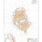
St Agnes, Gugh and Western Rocks on a very detailed walking and cycling map from Friendly Guides at 1:10,000 printed on thick, waterproof paper. A handy superscale map ideal for anyone on a day-trip to explore this area of the Scilly archipelago.The map is part of a series covering Cornwall and the Isles of Scilly; each map comes in a handy size measuring 59 x 21 cm, and it is double-sided to cover a wider area. Topography is indicated by different colourings for each type of terrain (sand, shingle, high or low cliffs, etc) and vegetation (woodlands, gorse, scrub, etc). An overprint highlights footpaths and recommended walks. Symbols show locations of campsites, pubs/cafes/restaurants, places of interest and ancient sites. The map also features a list of selected places to visit and recommended beaches. The map does not present a UTM grid (so it is not GPS compatible).To see the list of titles in this series please click on the series link.

Related Products:
 Friendly Guides: Lizard Peninsula and Isles of Scilly walking maps
 Friendly Guides: Lizard Peninsula and Isles of Scilly Pocket Map Colletions
 St Agnes: Gugh, Annet and the Western Rocks
 Dartmouth & Slapton Walking Map 25
 Tatras Western: Koscielisko and the Western Valleys (Tatry Zachodnie)
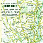 Sidmouth Walking Map 42
 Porlock Walking Map 02
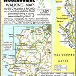 Mortehoe & Woolacombe Walking Map 07
 Ilfracombe & Berrynarbor Walking Map 06
 Hartland & Clovelly Walking Map 11
 Salcombe & Hope Walking Map 20
 Prawle & Beesands Walking Map 24
 Ottery St Mary Walking Map 41
 Kingsbridge & Loddiswell Walking Map 23
 Croyde Walking Map 08 – Georgeham & Saunton
 Horner & Dunkery Walking Map 03
 Bigbury, Avon & Erme Walking Map 22
 Beer – Branscombe – Seaton Walking Map 43
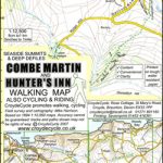 Combe Martin & Hunter`s Inn Walking Map 05
 Minehead – Dunster – Selworthy Walking Map 01
 Lynton – Lynmouth & Doone Valley Walking Map 04
 Bude – Morwenstow – Welcombe Walking Map 12
 Watchet & Quantock North Walking Map 55 – Kilve to Blue Anchor
 Newton Ferrers – Noss Mayo & Wembury Walking Map 21
 Augsburg NP – Western Forests UK50-32
 Lyme Regis Walking Map 45 – Undercliff to Golden Cap
 Musbury & Axminster Walking Map 44
 Bridport & West Bay Walking Map 46 – Golden Cap to Burton Bradstock
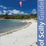 Isles of Scilly Guidebook: St Mary`s, St Agnes, Bryher, Tresco, St Martin`s
 Bavarian Forest Regional Park: western part
 Cotiella ‘“ Peรฑa Montaรฑesa Editorial Alpina
 Costabona – Alta Val de Ter Editorial Alpina
Upper Bavarian Forest Regional Park: western part – Regensburg East
Costabona – Alta Val de Ter Editorial Alpina
Upper Bavarian Forest Regional Park: western part – Regensburg East
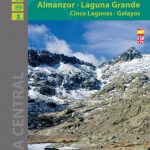 Sierra de Gredos – Almanzor – Laguna Grande Editorial Alpina
 Aotea / Great Barrier Island
 Coromandel Peninsula
 Redruth & St Agnes – Camborne & Perranporth OS Explorer Map 104 (paper)
 Redruth & St Agnes – Camborne & Perranporth OS Explorer Active Map 104 (waterproof)
 Mount Taranaki
 Tongariro NP: Ruapehu Round the Mountain Track