Disclosure : This site contains affiliate links to products. We may receive a commission for purchases made through these links.
Spain: Catalonia Topographic Atlas
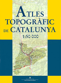
Topographic Atlas of Catalonia at 1:50,000 in a 262-page, A3, hardback format from the Institut Cartogrร fic de Catalunya, the region’s official survey organization with beautiful elegant cartography and extensive index. The atlas, with its map legend and all other explanatory text in Catalan only (no Spanish), provides an excellent picture of the region’s topography with contours at 20m intervals, hill shading and fine graphics/colouring to portray relief, terrain, vegetation types and landmarks. Boundaries of national parks and other protected areas are marked, as are internal administrative borders.Both road and rail networks are graded in detail, but please note that the current edition was published in 2004 so the atlas does not reflect any more recent developments. Also marked are long-distance GR routes. The maps have a 5-km UTM grid.The atlas has an extensive index which lists both towns or villages and geographical features. Also provides are an administrative map and an overview physical map of Catalonia.* PLEASE NOTE: the same cartography is also used in the ICC’s series of folded maps, ‘Spain: 50K Catalan Topographic Survey” offered on our website. These maps are regularly updated and include more tourist related information with an overprint highlighting long-distance GR trails and the Via Verde routes. Four different types of interesting locations are highlighted, indicating picturesque towns or villages, individual isolated building or monuments, natural sites, and hydrographic features such as waterfalls.

Related Products:
 Catalonia ICC Road Atlas
 Spain: 50K Catalan Topographic Survey
 Catalonia Topographic Map
 Spain: 100K Catalan Topographic Survey
 Spain: 25K Catalan Topographic Survey
 Spain – Portugal Marco Polo Road Atlas
 Latvia Jana Seta Compact Road Atlas
 Catalonia Editorial Alpina Road Map
 Lithuania Jana Seta Compact Road Atlas
 Spain: 50K Mainland Spain Civilian Topographic Survey
 Lithuania Jana Seta Road Atlas HARDBACK
 Morocco: Atlas Mountains Topographic Maps
 Latvia Jana Seta Road Atlas
Belarus Road Atlas
Latvia Jana Seta Road Atlas
Belarus Road Atlas
 Spain: 25K Mainland Spain Civilian Topographic Survey
Spain Road Atlas 2021 Set (incl. Map and DVD)
Spain: 25K Mainland Spain Civilian Topographic Survey
Spain Road Atlas 2021 Set (incl. Map and DVD)
 Spain: 50K Balearic Islands Civilian Topographic Survey
 India Road Atlas
Austria F&B Great Travel Atlas
India Road Atlas
Austria F&B Great Travel Atlas
 Catalonia Tourist Road – Regional Divisions Map
 Hungary – Budapest Road Atlas SPIRAL-BOUND
 Spain: The Way of St James 50K Topographic Survey Maps
 Germany: Baden-Wรผrttemberg 50K Topographic Survey Leisure Maps
Catalonia ICGC Road Map
Germany: Baden-Wรผrttemberg 50K Topographic Survey Leisure Maps
Catalonia ICGC Road Map
 Finland Road Atlas GLOVEBOX, SPIRAL-BOUND
 France & Spain Philip`s Road Atlas
 Vancouver Island and Haida Gwaii – SW British Columbia Back Road Atlas
 Ireland OSI Official Road Atlas A4
 Telde 25K Spain CNIG Topographic Survey Map No. 1104-IV
 Spain: 50K Balearic Islands Military Topographic Survey
 Germany: BKG 200K Topographic Maps
 Minnesota Recreational Atlas & Gazetteer
Gran Tarajal 25K Spain CNIG Topographic Survey Map No. 1100-II
Iceland Road Atlas 500K
Italy TCI Road Atlas
Minnesota Recreational Atlas & Gazetteer
Gran Tarajal 25K Spain CNIG Topographic Survey Map No. 1100-II
Iceland Road Atlas 500K
Italy TCI Road Atlas
 Austria – Liechtenstein – South Tyrol Marco Polo Road Atlas
Finland Karttakeskus Road Atlas
Austria – Liechtenstein – South Tyrol Marco Polo Road Atlas
Finland Karttakeskus Road Atlas
 Germany: Bavarian 50K Topographic Survey Leisure Maps
 Spain: 50K Canary Islands Civilian Topographic Survey
 Japan Traveler`s Atlas – most up-to-date Atlas for Visitors