Disclosure : This site contains affiliate links to products. We may receive a commission for purchases made through these links.
South West Corner – Margaret River & Southern Forest Hema
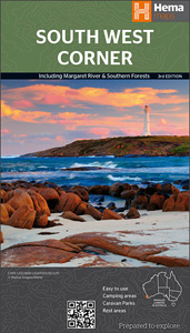
The south-western tip of Western Australia on a detailed map from Hema in their series of regional road maps. On one side is the south-western corner of the state at 1:200,000, extending north beyond Bunbury and Collie, eastwards to Boyup Brook and along the southern coast to cover the D’Entrecasteaux National Park. On the reverse the coastal Margaret River wine region is shown in greater detail at 1:100,000 with additional overprint highlighting locations of numerous vineyards.Both maps highlight numerous national parks, reserves, and state forests. Sandy dunes, swamps and areas liable to inundation, etc, are marked. Symbols indicate a very wide range of tourist facilities and places of interest, including accommodation, campsites and caravan parks, roadside rest areas, 24hour fuel supplies, general stores and medical facilities, access to beaches with 4DW vehicles, etc. Latitude and longitude lines are drawn at 10` intervals. This title also has a table listing local wineries with contact details and opening times,, a table showing facilities in the local national parks, plus tourist notes describing the region and its places of interest, including recommendations for popular walking and cycling tracks.To see the list of other regional map of Australia from Hema please click on the series link.

Related Products:
 South West Western Australia Hema
 South Australia Hema
 Outback New South Wales – from Broken Hill to Tamworth Hema Explorer Map
 North East New South Wales – Coffs Harbour to Brisbane Hema Explorer Map
 Mid West Western Australia Hema
 New South Wales Hema
 North East New South Wales Hema
 Outback Queensland Hema
Outback Queensland – Camooweal to Stanthorpe Hema Explorer Map
Outback Queensland Hema
Outback Queensland – Camooweal to Stanthorpe Hema Explorer Map
 Flinders Ranges SA Hema
 Pilbara and Coral Coast Hema Waterproof Map
 Western Australia Hema
 Western Australia Hema Road & 4WD Track Atlas A4 SPIRAL-BOUND
 South Island – New Zealand Hema
 South East Queensland Hema
 Top End and Gulf Hema Waterproof Map
 Victoria Hema
 The Kimberley – Gibb River Road Hema
Australia: Hema Regional Road Maps
The Kimberley – Gibb River Road Hema
Australia: Hema Regional Road Maps
 Central Queensland Hema
South East Queensland – featuring Landcruiser Mountain Park Hema Explorer Map
Central Queensland Hema
South East Queensland – featuring Landcruiser Mountain Park Hema Explorer Map
 Central Australia Hema 4WD Explorer Map
 Central Queensland – Hervey Bay to Mackay Hema
 Melbourne to Sydney Hema
 Perth and Region Hema
 Northern Territory Hema
Tasmania Hema
Northern Territory Hema
Tasmania Hema
 Australia Hema Road & 4WD Atlas PAPERBACK
 Savannah Way – Cairns to Broome Hema Touring Map
 Melbourne to Adelaide – featuring the Great Ocean Road and Victorian Goldfields Hema Touring Map
 Australia Hema Handy Atlas SPIRAL-BOUND
 Australia Hema Road & 4WD Touring Atlas A4 SPIRAL-BOUND
 Top End National Parks: Litchfield – Katharine – Kakadu Hema
 Brisbane to Cairns Hema
 Red Centre – Alice Springs to Uluru NT Hema
 Canberra and Region Hema
 Australia: Hema State Road Maps
 Perth & the South West – 4WD + Camping Escapes Atlas & Guide A4 SPIRAL-BOUND
North Queensland – from Cape York to Mackay Hema Explorer Map
Perth & the South West – 4WD + Camping Escapes Atlas & Guide A4 SPIRAL-BOUND
North Queensland – from Cape York to Mackay Hema Explorer Map