Disclosure : This site contains affiliate links to products. We may receive a commission for purchases made through these links.
South West Coast Path Map 2 – Big Beach Devon – Watermouth – Westward Ho! Map 58
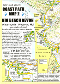
The central part of the northern section of the South West Coast Path National Trail in Devon between Watermouth and Westward Ho! on an exceptionally detailed contoured map from Croydecycle printed on light, waterproof and tear-resistant paper. The route from Watermouth to Saunton Sands is presented at 1:15,000, with the less demanding terrain around Braunton and the Taw/Torridge estuary at 1:30,000. Included in this title are street plans central Ilfracombe, Woolacombe, Barnstaple, Bideford, Croyde and Westward Ho!.Each of the publishers’ three handy size, 50 x 30cm maps covering the SWCP trail along the northern coast of Devon with the adjoining sections in Somerset and Cornwall presents the coast in five or six wide strips to enable exploration further inland and access to the path from local roads.Topography is indicated by contours at 10m intervals, enhanced by graphics and/or colouring for different types of terrain (high or low cliffs, step slopes, burrows, dunes, scree, salt marshes, etc) and vegetation (woodlands, gorse, scrub, etc). The maps also show the high tide level and classify beaches as sand, shingle, pebbles or rock. Where appropriate, the paths or the terrain are annotated with comments providing useful advice for hikers..An overprint indicates the course of the South West Coast Path with its variants, and shows other footpaths, permissive paths and small permissive paths, plus private roads with access on foot, as well as byways and bridleways. On roads which are part of the National Cycle Network route numbers are marked. Both the maps and the street plans have symbols highlighting campsites and other accommodation, pubs, cafes, restaurants, shops and other local facilities, etc. For GPS users each section has the lines of the National Grid coordinates. Also provided are details of local public transport, etc.The three maps of the South West Coast Path National Trail are part of a series of cycling and hiking maps of Devon at various scales from Croydecycle ‘“ please click on the link above to see the full list of titles.


