Disclosure : This site contains affiliate links to products. We may receive a commission for purchases made through these links.
South Ealing 1934 – 70.4
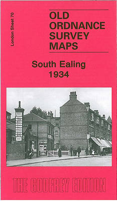
South Ealing in 1934 in a fascinating series of reproductions of old Ordnance Survey plans in the Alan Godfrey Editions, ideal for anyone interested in the history of their neighbourhood or family. Two versions of this map have been published, stretching from Elthorne Park eastward to Cedar Grove, and from Rathgar Avenue southward to Darwin Road. In 1894 this was still a largely rural area, and major features are St Mary`s church, a stretch of the District line with Boston Road and South Ealing stations, a small stretch of Grand Junction Canal with Osterley Lock; Little Ealing, with Ealing Park convent, Ealing Cemetery, and the beginning of building nearby; Lammas Park and village area around St Mary`s church. By 1934 most of the map had been built up. Selected directory extracts are included on both maps.About the Alan Godfrey Editions of the 25″ OS Series:Selected towns in Great Britain and Ireland are covered by maps showing the extent of urban development in the last decades of the 19th and early 20th century. The plans have been taken from the Ordnance Survey mapping and reprinted at about 15 inches to one mile (1:4,340). On the reverse most maps have historical notes and many also include extracts from contemporary directories. Most maps cover about one mile (1.6kms) north/south, one and a half miles (2.4kms) across; adjoining sheets can be combined to provide wider coverage.FOR MORE INFORMATION AND A COMPLETE LIST OF ALL AVAILABLE TITLES PLEASE CLICK ON THE SERIES LINK.

Related Products:
 Ealing 1934
 Ealing 1894
 Ealing 1913
 Hanworth and North West Hampton 1934
 Kempton Park & SW Hampton 1934 – 25.06
 Glasgow (Bellahouston & Dumbreck) 1934 – 6.13b
 West Twickenham & Strawberry Hill 1934 – 121b
 Ashford (North) 1934 – 19.16
Birmingham South 1913
Ashford (North) 1934 – 19.16
Birmingham South 1913
 South Acton & Gunnersbury Park 1935 – 71.4
Hornsey 1894 – 12.2
Trafford Park South 1937
South Acton & Gunnersbury Park 1935 – 71.4
Hornsey 1894 – 12.2
Trafford Park South 1937
 Sevenoaks South 1907
Carmyle 1934
Sevenoaks South 1907
Carmyle 1934
 Mid Finchley 1934
 Hornsey & Green Lanes 1935 – 12.4
 Croydon East: Coombe Park & Addiscombe Road 1895 – 158
North Surbiton and South Kingston 1932
Harborne South 1901
Croydon East: Coombe Park & Addiscombe Road 1895 – 158
North Surbiton and South Kingston 1932
Harborne South 1901
 Alexandra Park and South Friern 1935
 Alexandra Park & South Friern 1894 – 6a
 Alexandra Park & South Friern 1911 – 6b
 Perivale 1894
 South Croydon 1895 – 14.14
 South Croydon 1895 – 159.2
Willesden and Stonebridge Park 1936
Billingham South 1939
South Croydon 1895 – 159.2
Willesden and Stonebridge Park 1936
Billingham South 1939
 Beckenham South 1894
Enfield (South) 1895 – 7.07a
Worcester South-West 1902
Beckenham South 1894
Enfield (South) 1895 – 7.07a
Worcester South-West 1902
 Bromley South 1895
Colwyn Bay South East 1911
Central Glasgow 1934 – 6.10c
Bromley South 1895
Colwyn Bay South East 1911
Central Glasgow 1934 – 6.10c
 South Norwood 1895
 Croydon NW 1895 – 154
South Yardley and Hay Mills 1903
Barnsley South 1904
Bearwood 1903
Croydon NW 1895 – 154
South Yardley and Hay Mills 1903
Barnsley South 1904
Bearwood 1903
 Tottenham (North) 1894 – 8a
Leicester South West 1902-1911
Tottenham (North) 1894 – 8a
Leicester South West 1902-1911