Disclosure : This site contains affiliate links to products. We may receive a commission for purchases made through these links.
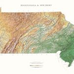
South Carolina Raven Maps Physical Wall Map PAPER
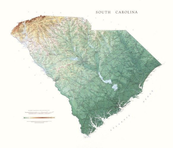
Detailed physical wall map of South Carolina State at a scale of 1:500,000. The cartography shows relief through a stunning, highly detailed shading, with different elevations varing in colouring, giving an almost 3-dimensional feel to the map. Peak heights are also clearly marked.The map displays land only within the boundaries of the chosen states – there is no overlap with neigbouring states. Principal physical features such as glaciers, mountain ranges, rivers and lakes are shown clearly. Human features, such as main towns, cities, roads and railways, are shown in a very fine, subtle and elegant cartographic style. State capitals are also clearly marked.This map measures 89x105cm (35″x41″). The Low Country of South Carolina, with its many rivers and swamps, also boasts a forested area know as the Pine Barrens. The Up Country to the northwest consists of rolling hills and the Blue Ridge Mountains. Sassafrass Mountain, at 3,554ft, is the highest point in the state.*About this series:*Located on the corner of Main and Central in downtown Medford, Oregon since 1986, Raven has become the quintessential small company with a big reputation. Every map is created with attention to accuracy and elegance, from gathering the base information to the final color adjustment on the printing press.

Related Products:
 South Dakota Raven Maps Physical Wall Map PAPER
 Minnesota Raven Maps Physical Wall Map PAPER
 Colorado Raven Maps Physical Wall Map PAPER
 Wyoming Raven Maps Physical Wall Map PAPER
 Nebraska Raven Maps Physical Wall Map PAPER
 Missouri Raven Maps Physical Wall Map PAPER
 Louisiana Raven Maps Physical Wall Map PAPER
 Tennessee Raven Maps Physical Wall Map PAPER
 Kansas Raven Maps Physical Wall Map PAPER
 Iowa Raven Maps Physical Wall Map PAPER
 New York Raven Maps Physical Wall Map PAPER
 West Virginia Raven Maps Physical Wall Map PAPER
 Hawaii Raven Maps Physical Wall Map PAPER
 Alabama Raven Maps Physical Wall Map PAPER
 Vermont & New Hampshire Raven Maps Physical Wall Map PAPER
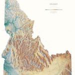 Idaho Raven Maps Physical Wall Map PAPER
 Utah Raven Maps Physical Wall Map PAPER
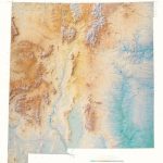 New Mexico Raven Maps Physical Wall Map PAPER
 Arizona Raven Maps Physical Wall Map PAPER
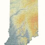 Indiana Raven Maps Physical Wall Map PAPER
 Oklahoma Raven Maps Physical Wall Map PAPER
 Arkansas Raven Maps Physical Wall Map PAPER
 Maine Raven Maps Physical Wall Map PAPER
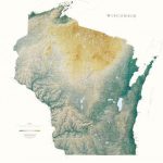 Wisconsin Raven Maps Physical Wall Map PAPER
 Pennsylvania and New Jersey Raven Maps Physical Wall Map PAPER
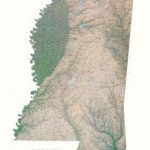 Mississippi Raven Maps Physical Wall Map PAPER
 North Carolina State Physical Wall Map
 North Dakota Raven Maps Physical Wall Map PAPER
 Massachusetts, Connecticut & Rhode Island Raven Maps Physical Wall Map PAPER
 Virginia, Maryland, Delaware & DC Raven Maps Physical Wall Map PAPER
 United States Raven Maps Physical Wall Map PAPER
United States Raven Maps Physical Wall Map LAMINATED
United States Raven Maps Physical Wall Map PAPER
United States Raven Maps Physical Wall Map LAMINATED
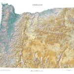 Oregon State Physical Wall Map
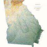 Georgia State Physical Wall Map
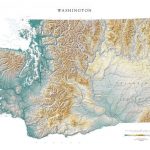 Washington State Physical Wall Map
 Montana State Physical Wall Map
 Alaska State Physical Wall Map
 Texas State Physical Wall Map
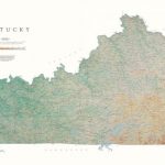 Kentucky State Physical Wall Map
 Nevada State Physical Wall Map