Disclosure : This site contains affiliate links to products. We may receive a commission for purchases made through these links.
South America Southern ITMB
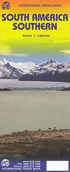
Southern South America at 1:2,600,000 in a series of three double-sided, indexed maps from ITMB, dividing the continent north/south and providing separate coverage of the Andes. Altitude colouring shows the topography and national parks or protected areas are highlighted.The maps present an overview of the continent’s road and rail networks and indicate local domestic airports. Various places of interest are highlighted, some accompanied by brief notes. Altitude tints, varying in colouring between the three maps, show the continents topography and numerous tributaries of the Amazon are named. *In this title:* double-sided map, with a separate index of localities for each side. The map shows the road and rail networks, and indicates local landing strips in the more remote parts of the interior. Important places of interest are highlighted. An inset has an enlargement for Isla Robinson Crusoe. Latitude and longitude lines are drawn at 1ยบ intervals.

Related Products:
 South America North ITMB
 South America: ITMB Sectional Maps
 South America ITMB
 South America ITMB Travel Atlas
 Ho Chi Minh City / Saigon & Vietnam South ITMB
 Chile South & Patagonia ITMB
 South East Asia ITMB
 Turkey South Coast ITMB
 Southern Vietnam – Mekong Delta ITMB
 Sao Paulo & Brazil South Coast ITMB
 Portugal & South of Spain ITMB
 India South & North East ITMB
 Myanmar / Burma ITMB
 England South & Wales ITMB
 China South ITMB
 Sikkim & India Northeast ITMB
 Bolivia ITMB
 Argentina South & Tierra del Fuego ITMB
 Hue – Da Nang & Vietnam Centra ITMB
 Scotland ITMB
 Yukon & Northwest Territories South West ITMB
 Germany South ITMB
 Taiwan & Taipei ITMB
 Togo & Benin ITMB
 Southern Ontario ITMB
 Pakistan ITMB
 US / Mexico Border ITMB
 Vietnam, Laos & Cambodia ITMB
 Afghanistan ITMB
 Africa: ITMB Sectional Maps
 Siberia ITMB
 Helsinki & Southern Finland ITMB
 Turkey Central – Cappadocia ITMB
 Mongolia ITMB
 Alberta ITMB
 Spain & Portugal ITMB
 Los Angeles & Southern California ITMB
 Shanghai & China South East ITMB
 Kazakhstan & Uzbekistan ITMB
 San Francisco & Northern California ITMB