Disclosure : This site contains affiliate links to products. We may receive a commission for purchases made through these links.
Sofia Street Atlas with Vitosha Massif
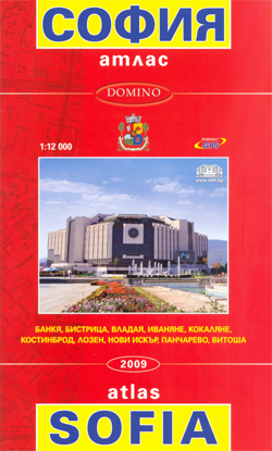
Street Atlas of Sofia with its outer suburbs and satellite districts at 1:12,000, with a topographic map of the Vitosha massif at 1:50,000 and a 4-page English language to the capital. The city’s tram, trolleybus and bus lines are shown with stops and line numbers. One way streets are marked, plus car parks, locations of petrol stations and car repair services. Symbols indicate various other services and places of interest. Streets show selected house numbers for easier identification of addresses. Names of main streets are given in both Cyrillic and Latin alphabet, smaller streets and other information is in Cyrillic only. The index list changes in street names since 2002 and includes a very extensive gazetteer of various services including hotels. Map legend and all information apart from the 4-page English language guide is in Bulgarian only, but website addresses in the gazetteer section are given in the Latin alphabet.The atlas also includes a 2-page map covering the Vitosha massif at 1:50,000, with contours at 20m intervals plus graphics and colouring for rocks, marshland, woodlands, etc. The map shows access to the mountain by public transport and indicates cable car lines and chair or ski lifts, hotels and mountain shelters, rescue posts, etc. Waymarked hiking routes are highlighted. All place names and the legend are in Cyrillic and the legend is in Bulgarian only.

Related Products:
 Vitosha – Verila
 Sofia Domino Street Plan
 Skopje Street Atlas
 Bansko (with Pirin National Park)
 Plovdiv
 Bansko (with Ski Routes)
 Pleven
 Mumbai (Bombay) Street Atlas
 Bulgaria Road Atlas
 Zurich Pocket Street Atlas
 Shumen
 Stara Zagora
 Helsinki Region Street Atlas
 Manhattan Block-by-Block Street Atlas
 Chennai / Madras Street Atlas
 Smolyan – Chepelare – Pamorovo and the Surrounding Area
 Delhi Street Atlas
 Kaliningrad Street Plan
 Oslo Cappelen Street Atlas
 Riga and Vicinity Jana Seta Street Atlas
 Valencia Pocket Street Atlas
 Moscow Street Atlas
 Barcelona: Greater Barcenona Telstar Street Atlas
 Budapest Street Atlas
 Bulgarian and Romanian Coast
 Varna
Varna
 Aberdeen A-Z Street Atlas
 Tokyo City Atlas – a Bilingual Guide
 Irkutsk
 Isle of Wight A-Z Street Atlas
 Dartford – Gravesend A-Z Street Atlas
 Weymouth – Dorchester A-Z Street Atlas
 West Lothian Street Atlas
 Glasgow – Hamilton – Motherwell – Paisley A-Z Street Atlas
 Hastings – Bexhill – St. Leonards – Rye A-Z Street Atlas
 Bolton – Bury A-Z Street Atlas
 Manchester A-Z Big Street Atlas SPIRAL-BOUND
 Torbay – Brixham – Paignton – Torquay A-Z Street Atlas
 Wirral – Birkenhead – Ellesmere Port – Wallasey A-Z Street Atlas
Southport – Formby – Ormskirk – Skelmersdale A-Z Street Atlas
Wirral – Birkenhead – Ellesmere Port – Wallasey A-Z Street Atlas
Southport – Formby – Ormskirk – Skelmersdale A-Z Street Atlas