Disclosure : This site contains affiliate links to products. We may receive a commission for purchases made through these links.
Slovenia – Istria
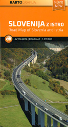
Slovenia with the whole of Istria and the nearby islands on an indexed road map at 1:270,000 from Kartografija, with an enlargement showing in more detailed road access to central Ljubljana. Coverage includes much of Carinthia and north-western Croatia with Zagreb, plus on the reverse in a separate panel Istria with the islands of Krk, Cres, Rab and the northern part of Pag, together with the adjoining mainland.Topography is shown by light altitude colouring, with relief shading and plenty of names of mountain chains, peaks and other geographical features. Road network includes selected small local roads and tracks, and indicates toll routes, steep gradients, seasonal closures, etc, as well as locations of petrol stations. Driving distances are shown on main and secondary routes. Railway and ferry lines are included and local airports are marked. Symbols indicate campsites, locations with hotels, various places of interest, etc. Latitude and longitude lines are drawn at 15’ intervals. The index is on the reverse of the main map. Map legend includes English.An enlargement at 1:75,000 shows in greater detail the area around Ljubljana’s ring-road and the access to the city centre.

Related Products:
 Istria – Kvarner
 Dalmatia – Istria
 Croatia – Slovenia Marco Polo Map
 Istria – Pula F&B Top 10 Tips
 Slovenia, Croatia and Bosnia-Herzegovina
 Slovenia F&B Top 10 Tips
 Istria K+F Outdoor Map
 Croatia North – Istria – Zagreb – Slavonia F&B
 Climbing without Frontiers Istria. Italy, Slovenia, Croatia.
 Ljubljana
 Istria Reise Know-How
 Istria Kompass 238
Istria: Recipes and Stories from the Hidden Heart of Italy, Slovenia and Croatia
Istria Kompass 238
Istria: Recipes and Stories from the Hidden Heart of Italy, Slovenia and Croatia
 Croatia – Slovenia F&B Road Atlas
 Slovenia – Croatia – Bosnia-Herzegovina F&B
 Slovenia F&B
 Croatia Coast – Istria – Dalmatia – Dubrovnik F&B
 Istria F&B Pocket Map
 Slovenia Kartografija Top 15 Guide
 Dalmatia 2-Map Set
 Istria Region Bikeline Cycling Atlas
 Slovenia – Croatia – Serbia – Bosnia-Herzegovina – Macedonia – Kosovo – Montenegro F&B
 Slovenia: Kartografija 75K Hiking Maps
 Slovenia Kartografija Road Atlas
 Germany North West Michelin Regional 541
 Ecuador Borch
 Maribor
 Germany Mideast Michelin Regional 544
 Germany Northeast Michelin Regional 542
 Germany Southwest Michelin Regional 545
 Istria: Cicarija Plateau Croatian Mountain Rescue Service 25K Map
 Coast Around Lisbon Turinta
 Croatia – Istria & Dalmatia Insight Travel Map
 Balearic Islands Michelin Regional 579
 Prague F&B
 Sicily Michelin Local 365
 Ukraine – Moldova Gizi Map
 Belarus Jana Seta Road Map
 Croatia – Istria Bradt Guide