Disclosure : This site contains affiliate links to products. We may receive a commission for purchases made through these links.
Skadar Lake National Park
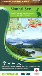
Skadar Lake National Park in Montenegro including the adjoining area with the Adriatic coast, plus the Albanian side of the lake, on a detailed, contoured and GPS compatible map at 1:55,000 from Huber Verlag. Contours at 10m intervals are enhanced by relief shading, graphics to show swamps and colouring indicating woodlands and vineyards. An overprint highlights waymarked hiking and cycling routes and symbols indicate locations with tourist accommodation, cafes and restaurants, bird-watching towers, beaches, etc. The map also prominently highlights various sites for bird watching and exploration of local flora and geology. Road network shows petrol stations and railway lines are presented with stations. The map has both 1-km UTM grid and latitude/longitude lines at intervals of 5’, and is indexed. Map legend includes English.On the reverse are notes about the area, a list of nine GPS waypoints for particularly interesting sites, plus photos and descriptions of over 50 examples of local flora and fauna. All the text is in German only, but names of plants and animals are also in Latin and English.

Related Products:
 Picos de Europa National Park 3-Map and Guide Set CNIG ENGLISH
 Picos de Europa National Park 3-Map and Guide Set CNIG SPANISH
 Galicica National Park
 Lake District National Park Aerial Map
 Sierra de Guadarrama National Park 4-Map and Guide Set CNIG
 Lake Manyara National Park
 Mavrovo National Park
 Vlasina Lake
 Lake Balaton Cycling Atlas
 Lake Manyara & Tarangire National Park
 Zemaitija National Park
Dzukija National Park East
Dzukija I National Park West
Zemaitija National Park
Dzukija National Park East
Dzukija I National Park West
 Lake Maggiore – Lake Orta – Lake Varese K+F Outdoor Map 8
Aukstaitija National Park
Lake Maggiore – Lake Orta – Lake Varese K+F Outdoor Map 8
Aukstaitija National Park
 Crater Lake National Park OR NGS Trails Illustrated Map 244
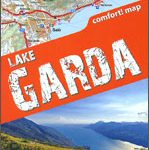 Lake Garda terraQuest Trekking Map
 Osogovski National Park
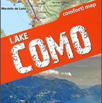 Lake Como terraQuest Trekking Map
 Dzukija National Park
ลฝemaitija National Park
Aukลกtaitijos National Park
Moletai Lake District
Lake Asveja and Environs
Curonian Spit National Park
Dzukija National Park
ลฝemaitija National Park
Aukลกtaitijos National Park
Moletai Lake District
Lake Asveja and Environs
Curonian Spit National Park
 Picos de Europa National Park 2-Map Set Editorial Alpina
 Paklenica National Park
 Triglav National Park Kartografija WATERPROOF Hiking Map
 Longs Peak – Bear Lake / Wild Basin – Rocky Mountains National Park CO
 Antuco – Laguna del Laja National Park
 Lake District National Park Collins Pocket Map
 Lake Garda – Lake Idro – Monte Baldo – Verona K+F Outdoor Map 7
Slowinski National Park ExpressMap Tourist Map
Lake Garda – Lake Idro – Monte Baldo – Verona K+F Outdoor Map 7
Slowinski National Park ExpressMap Tourist Map
 Yellowstone Lake – Yellowstone National Park WY
 Lake District National Park: 10 Leisurely Walks
 La Tablas de Daimiel National Park CNIG Map-Guide SPANISH
 Ordesa and Monte Perdido National Park 2-Map Set Editorial Alpina
 Ordesa – Monte Perdido National Park Editorial Alpina 2-Map Set
 Los Glaciares National Park
 Ordesa and Monte Perdido National Park Editorial Alpina