Disclosure : This site contains affiliate links to products. We may receive a commission for purchases made through these links.
Singapore & Malay Peninsula ITMB

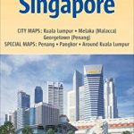
Singapore City on a clear, indexed street plan at 1:10,000 with from ITMB, highlighting numerous places of interest and tourist facilities, plus the Singapore Island shown at 1:100,000 with its road and rail networks.The street plan covers the city’s central districts as indicated in our area coverage image, including the Financial District, Chinatown, Little India, Orchard Road Shopping District and Sentosa Island. Coverage north extends to the Whampoa flyover.Main traffic arteries are highlighted and one way streets are shown. MRT subway stations indicate which lines stop there and ferry lines are marked. Symbols highlight locations of numerous hotels and shopping centres, various places of interest, pubic buildings, all with names. The plan is indexed and includes a large inset showing Singapore Island at 100,000 with its road and railway networks, annotated with main places of interest. Also included is a diagram of the city’s subway and rail system, plus insets with LRT lines in Punggol and Bukit showing individual station names.

Related Products:
 Singapore Periplus Travel Map
 Singapore Borch
 Malaysia West – Singapore Nelles
 Kuala Lumpur & Malay Peninsula ITMB
 Taiwan & Taipei ITMB
 Bahrain and Manama City ITMB
 Singapore F&B
 Tehran & Northern Iran ITMB
 Krakow ITMB
 Tokyo & Central Japan ITMB
 Qatar and Doha City ITMB
 Manhattan & New York State ITMB
 Jerusalem & Holy Land ITMB
 Moscow ITMB
 Tel Aviv-Jaffa & Central Israel ITMB
 Helsinki & Southern Finland ITMB
 Brisbane & Queensland ITMB
 Guangzhou & China South ITMB
 India North East & Kolkata / Calcutta ITMB
 Auckland & North Island ITMB
 Easter Island & Santiago ITMB
 Finland & Sweden ITMB
 Singapore PopOut
 China West ITMB
 Southern Vietnam – Mekong Delta ITMB
 Seattle & Northwest USA ITMB
 Jakarta ITMB
 Ho Chi Minh City / Saigon & Vietnam South ITMB
 Zurich & Switzerland NW ITMB
 Warsaw & Poland East ITMB
 Kuwait & Kuwait City ITMB
 Osaka & Western Japan ITMB
 Sao Paulo & Brazil South Coast ITMB
Sydney & Australia East ITMB
Sao Paulo & Brazil South Coast ITMB
Sydney & Australia East ITMB
 Hungary & Budapest ITMB
 China South ITMB
 Iran & Tehran ITMB
 San Francisco & Northern California ITMB