Disclosure : This site contains affiliate links to products. We may receive a commission for purchases made through these links.
Singapore Borch
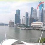
Laminated and waterproof map for visitors to Singapore from Borch, highlighting top 30 sights and combining a street plan of Singapore city’s central districts with a road map of the Singapore Island, plus maps of Sentosa Island, Changi Airport and public transport network.On one side is a street plan at 1:14,000 of Singapore City’s central districts, highlighting selected accommodation, various places of interest and facilities. Metro stations are prominently marked and annotated with line numbers. For drives the map indicates main traffic arteries, one way streets and car parks. The index lists streets, as well as districts, public buildings/sights, hotels, shopping centres, etc. On the reverse are indexed maps of the Singapore Island at 1:120,000 showing its road and rail networks, with Sentosa Island in greater detail at 1:25,000. Singapore’s 30 top sights are prominently highlighted, as appropriate, on the main city street plan and on the two road maps.Also provided is a diagram of the MRT/LRT network, plus a plan showing road access to the terminals at Changi Airport.

Related Products:
 Singapore & Malay Peninsula ITMB
 Malaysia West – Singapore Nelles
 Singapore Periplus Travel Map
 Madrid Borch
 Athens Borch
 Boston Borch
 Frankfurt am Main Borch
 Philadelphia Borch
 Brussels Borch
 Sydney Borch
 Istanbul Borch
 Prague Borch
 Singapore Flexi Map
 Singapore PopOut
 Lisbon Borch
 Barcelona Borch
 Phoenix Borch
 Los Angeles Borch
 Washington DC Borch
 Hamburg Borch
 Stockholm Borch
 Florence Borch
 Copenhagen Borch
 Beijing Borch
 New York City Borch
 Salzburg F&B Street Plan
 New Orleans Borch
 Berlin Borch
 Singapore Lonely Planet City Map
 Rome Borch
 Chicago Borch
 Paris Borch
 Vienna Borch
 Cape Town Borch
 Jerusalem Borch
 Bangkok Borch
 Montreal
 Amsterdam Borch
 Singapore F&B