Disclosure : This site contains affiliate links to products. We may receive a commission for purchases made through these links.
Sierra Nevada Destination Map
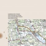
Sierra Nevada on a double-sided road map at 1:543,000 from the National Geographic, highlighting numerous places of interest and printed on light, waterproof and tear resistant synthetic paper. On one side coverage extends from the California/Oregon border to Sacramento and includes the region of Nevada around Lake Tahoe and Pyramid Lake. On the reverse the map shows the most visited part of the Sierra Nevada from Lake Tahoe, across the Yosemite National Park and the Sequoia Range, to Tehachapi Pass.The base map is taken from satellite imagery and has plenty of names of topographic features, including peaks with heights given both in feet and metres. Borders of national parks, forests and the region’s other numerous protected areas, as well as of Indian Reservations, are prominently highlighted. Road network includes unpaved roads and indicates national and other Scenic Byways. Also marked is the course of the Pacific Crest hiking trail. Symbols indicate visitor centres, ski resorts and places of interest, many annotated with brief notes. Latitude and longitude lines are drawn at 1ยฐ intervals. Also provided is a table listing facilities and outdoor opportunities in the region’s national parks, and more general notes about the Sierra Nevada, its culture and heritage, etc.

Related Products:
 Sierra Nevada
 Sierra Nevada – the Traverse at 3000m Editorial Piolet
 John Muir Trail – Through the Californian Sierra Nevada
 Sierra Nevada – La Alpujarra Editorial Alpina
 50 Hikes in the Sierra Nevada
 Sierra Nevada Mountain Guidebook
 Granada & Sierra Nevada
 Sierra Nevada – Las Alpujarras CNIG Map
 Sierra Nevada – the Alpujarra – Marquesado del Zenete Editorial Penibetica Map and Guide
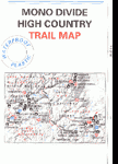 Mono Divide High Country
 California – Nevada NGS Adventure Map 3119
 Tahoe Rim Trail Map-Guide
 Nevada Easy-to-Read Rand McNally
 Moon Nevada
 GR 240: Tour of the Sierra Nevada (Sendero Sulayr)
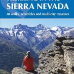 Walking and Trekking in the Sierra Nevada: 38 walks, scrambles and multi-day traverses
 Nevada Road & Recreation Atlas
 Sierra Leone ITMB
 Lake Tahoe Basin Trail Map
 Sierra Crestellina – Sierra de la Utrera Birding Map
 Sierra de Guadarrama
 Canadian Rockies NGS Destination Map
 Blue Ridge Parkway NC/VA Destination Map
 Tahoe National Forest – Sierra Buttes / Donner Pass CA
 Mount Whitney High Country
 Valle de Ricote – Sierra de Ricote – Sierra del Oro
 Nevada Recreational Map
 Highway 395 – Carson City NV to Lone Pine CA Benchmark Road Map
 Pacific Crest Trail – Oregon South NGS Topographic Map-Guide 1005
 The Pacific Crest Trail: Hiking America`s Wilderness Trail
 Sierra de Guadarrama National Park 4-Map and Guide Set CNIG
 Alaska`s Inside Passage NGS Destination Map
 Pacific Crest Trail – Washington North NGS Topographic Map-Guide 1002
 California – Nevada USA 05 Hallwag Road Map
 Sierra de Aracena Tour & Trail Map
 California – Nevada Michelin Zoom 174
 Shaver Lake – Sierra National Forest CA
 Nevada & Utah Easy to Fold Rand McNally
 Four Corners Region Destination Map
 Pacific Crest Trail – Washington South NGS Topographic Map-Guide 1003