Disclosure : This site contains affiliate links to products. We may receive a commission for purchases made through these links.
Sieg River Long-distance Trail
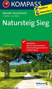
The Sieg River long-distance hiking trail, a 111km path along the Sieg from Au to Siegburg, just east of Cologne and Bonn. The route is presented on 4 panels, accompanied by street plans Au ‘“ Hamm and Siegburg. Maps in this new series from Kompass, begun in summer 2014, are at 1:50,000, contoured and GPS compatible, and printed on sturdy but light waterproof and tear-resistant synthetic paper. Each route is prominently highlighted on a series of 17.5 x 20cm panels and annotated with 5km markers. Topography is shown by contours (intervals at 20m or 40m) enhanced by relief shading with colouring and/or graphics for woodlands, orchards, vineyards, etc. Symbols indicate various accommodation options (hotels, campsites, youth hostels), sport facilities, and various places of interest. The maps also show locations of car parks near the route and railway lines are shown with stations. The maps have a 2km UTM grid. Each title includes street plans of local towns, a route profile, details of recommended accommodation indicating price range, plus descriptions of main places of interest. Map legend and all the text are in German only.To see other titles in this series please click on the series link.

Related Products:
 Hermannsweg und Eggeweg – die Hermannshohen Kompass Long-distance Trail Map 2504
 Hermannsweg & Eggeweg Long-distance Trail: Teutoburger Wald – Eggegebirge
 Eifelsteig long-distance Trail Kompass 2502
 Rheinsteig long-distance Trail Kompass 2503
Germany and Alpine Regions of Europe: Kompass Maps of Long-distance Footpaths
Rheinsteig long-distance Trail Kompass 2503
Germany and Alpine Regions of Europe: Kompass Maps of Long-distance Footpaths
 Lake Constance to Verona – E5 European Long-Distance Trail Kompass 2558
 SalzAlpenSteig: Chiemsee – Kรถnigssee -Halstรคtter See
 Mozart Bike Trail F&B RK3
 Hungarian National Long-distance Blue Trail (E7): Irott-ko to Szekszard
 Inn Bike Trail: Landeck – Passau Freytag & Berndt Map
 Kamp – Thaya – March Bike Trail Freytag & Berndt Map
 Tauern Bike Trail: Krimml – Passau Freytag & Berndt Map
Hungarian National Long-distance Blue Trail (E4): Visegrad to Irott-ko
Tauern Bike Trail: Krimml – Passau Freytag & Berndt Map
Hungarian National Long-distance Blue Trail (E4): Visegrad to Irott-ko
 Hawaii – Kauai Nelles
 Tour du Mont Blanc: The most iconic long-distance, circular trail in the Alps with customised itinerary planning for walkers, trekkers, fastpackers and trail runners
 Transrhodopi – Long distance hiking and biking trail From Trigrad to Ivaylovgrad
 Australia Periplus Travel Map
 Munich-Venice Long Distance Cycle Route – incl Dolomites Route Bikeline Map-Guide
 Garden Route & Route 62 Map Studio
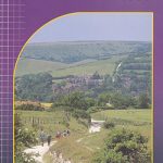
 Walking Hampshire`s Test Way: The long-distance trail and 15 day walks
 Peaks of the Balkans Long-Distance Hiking Trail: Albania ‘“ Kosovo ‘“ Montenegro
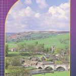 Dales Way Harvey National Trail XT40
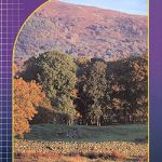 Cumbria Way Harvey National Trail XT40
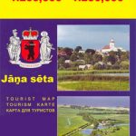
 Latgale South Jana Seta Tourist Map
 Tyrol Mountain Bike Trail (1000km) Bikeline Atlas
Trans-Alpine Crossing – Tegernsee – Achensee – Zillertal – Sterzing Kompass 2556
Tyrol Mountain Bike Trail (1000km) Bikeline Atlas
Trans-Alpine Crossing – Tegernsee – Achensee – Zillertal – Sterzing Kompass 2556
 Kurzeme South Jana Seta Tourist Map
 Central Latvia Jana Seta Tourist Map
 Main River Cycle Route Bikeline Map-Guide
 Lithuania: Jana Seta 200K/250K Regional Touring Maps
Cotswold Way Harvey National Trail XT40
Lithuania: Jana Seta 200K/250K Regional Touring Maps
Cotswold Way Harvey National Trail XT40
 Drau / Drava Cycle Route – from Source to River Mur Bikeline Map-Guide
 Bali Periplus Travel Map
 St Cuthbert`s Way Harvey National Trail XT40
 South Downs Way Harvey National Trail XT40
Europe: Bikeline Map/Guides of Long-distance Cycling Routes
Kurzeme North Jana Seta Tourist Map
South Downs Way Harvey National Trail XT40
Europe: Bikeline Map/Guides of Long-distance Cycling Routes
Kurzeme North Jana Seta Tourist Map
 Pennine Way National Trail
 Yangzi River Odyssey Map
 France: Chamina Maps of Long-distance Mountain Bike Routes