Disclosure : This site contains affiliate links to products. We may receive a commission for purchases made through these links.
Siberia ITMB
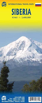
Siberia on a double-sided, indexed map at 1:3,600,000 from ITMB with coverage extending from Omsk, Nefteyugansk and Vorkuta in the west to the Sakhalin Island. All place names are in the Latin alphabet. Topography is presented by altitude colouring with bands in feet. The map shows the region’s road and rail networks, also indicating locations with airports and landing grounds, and symbols highlight various places of interest. Each side has a separate index. Latitude and longitude are shown by very faint lines at 5ยบ intervalsPLEASE NOTE: the course of the Trans-Siberian Railway east of Omsk is clearly marked, but coverage of the map in the south-east stops about halfway between Khabarovsk and Vladivostok. Vladivostok itself, as well as Kamchatka and the easternmost part of Chukotka are also not included.

Related Products:
 Kamchatka & Eastern Siberia ITMB
 Russia ITMB
 Portugal & South of Spain ITMB
 Florida & US Deep South ITMB
 India North and West ITMB
 Great Lakes ITMB
 Argentina South & Tierra del Fuego ITMB
 Germany South ITMB
 Bangladesh & India East ITMB
 Ontario ITMB
 South East Asia ITMB
 Kazakhstan & Uzbekistan ITMB
 Saudi Arabia & Kuwait ITMB
 Trans-Siberian ITMB Railroad Atlas
 Mongolia ITMB
 Jordan & Syria ITMB
 Africa South & Central ITMB
 USA Western Railroads/Highways ITMB
 Fiji & Tonga ITMB
 India South & North East ITMB
 Morocco ITMB
 Arizona & New Mexico ITMB
 Japan North & Hokkaido ITMB
 Himalaya ITMB
 Czech Republic ITMB
 Pakistan ITMB
 Grand Canyon & Arizona ITMB
 Texas & Oklahoma ITMB
 Scotland ITMB
 India ITMB
Oman & Yemen ITMB
India ITMB
Oman & Yemen ITMB
 Africa East & Central ITMB
 Bolivia ITMB
 Central USA & the Mississippi River ITMB
 USA Southwest ITMB
 Midnight in Siberia: A Train Journey into the Heart of Russia
 Romania & Moldova ITMB