Disclosure : This site contains affiliate links to products. We may receive a commission for purchases made through these links.
Shanghai & China South East ITMB
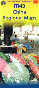
Shanghai on a clear, well-presented indexed street plan from ITMB, printed on light, waterproof and tear-resistant plastic paper, with on the reverse an indexed road map covering many of China’s most visited cities, including Beijing, Xi’an and Hong Kong.On one side is a street plan of Shanghai’s inner districts, extending from the Zhongshan Inner Evelvated Ring Road in the west to the Long Yang Rd. Maglev railway station in Pudong. North/south the plan extends from the Hongkou Football Stadium to the Shanghai Indoor Stadium Complex and the site of the 2010 World Expo (part of the World Expo South Site is not shown on the plan).The plan highlights main traffic routes and clearly shows metro, elevated rail lines and railways, including lines under construction, with metro stations annotated with different entrances/exits and line numbers. Ferry connections along and across the Huangpu River are marked. Symbols highlight various places of interest and facilities, including selected hotels, shopping malls, temples, cultural institutions, etc. The plan is indexed and includes a diagram of the metro network, with proposed extensions, plus a small inset showing the environs of the city with Pudong International Airport and the Yangtze.On the reverse is an indexed road map of the south-eastern part of China, extending north to beyond Beijing, west to Xi’an, and south to the border to include Hong Kong, Macau, Guangzhou and Nanning, as well as Taiwan. The map has altitude colouring (in feet) and shows the country’s road and rail networks and local airports. Symbols highlight various places of interest including The Great Wall. The map is indexed and has latitude and longitude lines are drawn at intervals of 2ยฐ.


