Disclosure : This site contains affiliate links to products. We may receive a commission for purchases made through these links.
Serra d`Irta Natural Park – Columbretes Islands
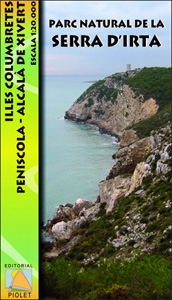
Serra d`Irta Natural Park and the Columbretes Islands on the Mediterranean coast of Spain north of Castellรณ de la Plana on a contoured and GPS compatible map at 1:20,000 from Editorial Piolet. Coverage of the mainland extends along the coast from Alcosserbe in the south to beyond Penรญscola, and inland across the Serra d’ Irta to Alcalร de Xivert. The Columbretes Islands are shown at 1:5,000 on four separate panels.Topography is presented by contours at 10m intervals with plenty of additional spot heights. An overprint shows waymarked local routes, with special highlighting for eight recommended hiking trails and three cycling routes. Symbols indicate various facilities and places of interest including different types of accommodation (hotels, campsites, gรฎtes, etc), tourist information offices, restaurants, banks/cash points, petrol stations and car parks, interesting rock formations, etc. The map has a 1-km UTM grid; map legend includes English. To see the list of titles in this series please click on the series link.

Related Products:
 Taga – Serra Cavallera Editorial Alpina
 Serra del Cadรญ – Pedraforca Editorial Alpina
 Marina Baixa – Serra d`Aitana Editorial Piolet
 Serra de Bernia – Marina Alta Editorial Piolet
 Serra de Pร ndols and Serra de Cavalls
Serra de Boumort – 2-Map Set
Serra de Pร ndols and Serra de Cavalls
Serra de Boumort – 2-Map Set
 Serra de Miramar
 Serra de Llaberia Editorial Piolet
 Mallorca – Serra de Tramuntana
Serra de Montsant
Mallorca – Serra de Tramuntana
Serra de Montsant
 Delta of the Ebro ‘“ Serra de Montsiร Editorial Alpina
 Serra da Estrela Nature Park
 Cap de Creus Park Natural Editorial Alpina
Islas Columbretes CNIG Topo 642
Cap de Creus Park Natural Editorial Alpina
Islas Columbretes CNIG Topo 642
 Lastovo Islands Nature Park
 Organyร -Boumort – Serra de Taรบs
Tremp – la Pobla de Segur – Serra de Boumort – Isona
L`Albera Natural Park
Organyร -Boumort – Serra de Taรบs
Tremp – la Pobla de Segur – Serra de Boumort – Isona
L`Albera Natural Park
 Cap de Creus Natural Park
Serra de Tramuntana Editorial Alpina 4-Map Set
Cap de Creus Natural Park
Serra de Tramuntana Editorial Alpina 4-Map Set
 Figueres – Aiguamolls dels Empordร Natural Park
 Serra Tramuntana 2-Map Set
Els Ports Natural Park: Vall-de-roures – Arnes
Serra Tramuntana 2-Map Set
Els Ports Natural Park: Vall-de-roures – Arnes
 Islas de Cรญes Natural Park CNIG Map
 Alt Pirineu Natural Park Editorial Alpina
 Rasos de Peguera – Serra d`Ensija Editorial Alpina
 Cavalls del Vent – Cadi-Moixero Natural Park Hiking Circuit Editorial Alpina
Cadรญ-Moixerรณ Natural Park West: la Seu d’Urgell – Vall de la Vansa
Cavalls del Vent – Cadi-Moixero Natural Park Hiking Circuit Editorial Alpina
Cadรญ-Moixerรณ Natural Park West: la Seu d’Urgell – Vall de la Vansa
 Maritime Alps Natural Park – Entracque – Valdieri – Mercantour – Gelas IGC 113
 Cabo de Gata-Nรญjar Natural Park Editorial Alpina
 Aeolian (Lipari) Islands Global Map Tourist Map
 Lofoten and Vesteralen Islands
Caรฑรณn del Rรญo Lobos Natural Park
Lofoten and Vesteralen Islands
Caรฑรณn del Rรญo Lobos Natural Park
 Alt Pirineu Natural Park NE: Pica d’Estats – Vall de Cardos – Vall Ferrera
 Islands of the Galician Coast National Park CNIG Map-Guide SPANISH
 Moixerรณ – La Tosa – Cadรญ-Moixerรณ Natural Park Editorial Alpina
 Urbasa and Andรญa Natural Park CNIG Map
 Vall de Lord – Port del Comte Editorial Alpina
 Posets-Maladeta Natural Park 2-Map Set Editorial Alpina
 Bavarian Forest National Park – Nature Park East UK50-29