Disclosure : This site contains affiliate links to products. We may receive a commission for purchases made through these links.
Serra de Bernia – Marina Alta Editorial Piolet
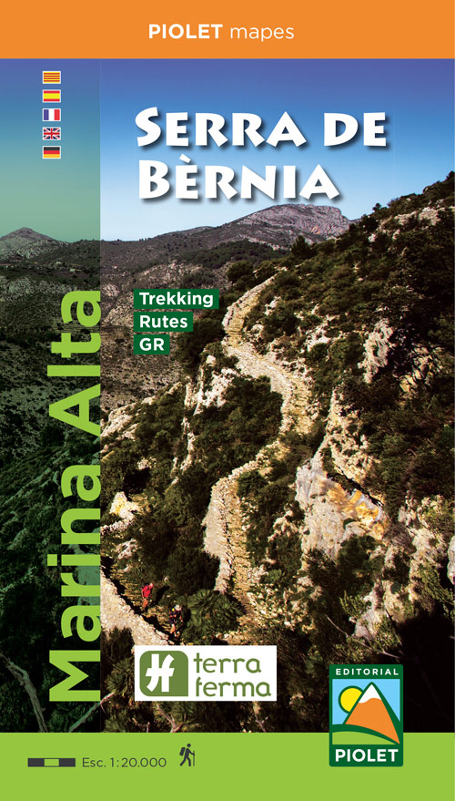
Marina Alta: Serra de Bernia area at 1:20,000 in a series of GPS compatible maps from Editorial Piolet with cartography based on Spain’s civilian topographic survey overprinted with hiking routes and other tourist information. Road network indicates locations of petrol stations. Local villages are annotated to show what facilities can be found there, including accommodation, restaurants, etc.Hiking maps in the Editorial Piolet series, unless indicated to the contrary in the individual description, have contours at 10m intervals, enhanced by relief shading and/or altitude colouring, and provide very detailed presentation of the terrain and local road network. An overprint highlights hiking routes, distinguishing between short local routes, longer PR paths and long-distance GR routes. Symbols mark campsites and mountain huts or refuges, various places of interest, climbing or other recreational areas, etc. Each title has a UTM grid. Map legend includes English.To see other titles in this series please click on the series link.

Related Products:
 Marina Baixa – Serra d`Aitana Editorial Piolet
 Serra de Llaberia Editorial Piolet
El Moncayo Editorial Piolet
Serra de Llaberia Editorial Piolet
El Moncayo Editorial Piolet
 Geoparque de las Sierras Subbeticas Editorial Piolet
Spain: Editorial Piolet Hiking Maps
Sierra Nevada – the Traverse at 3000m Editorial Piolet
Geoparque de las Sierras Subbeticas Editorial Piolet
Spain: Editorial Piolet Hiking Maps
Sierra Nevada – the Traverse at 3000m Editorial Piolet
 La Ruta del Caracremada Editorial Piolet
 Cami de l`Ossa – Andorra Editorial Piolet
Serra de Boumort – 2-Map Set
Cami de l`Ossa – Andorra Editorial Piolet
Serra de Boumort – 2-Map Set
 Serra de Miramar
Serra de Montsant
Serra de Miramar
Serra de Montsant
 Serra de Pร ndols and Serra de Cavalls
Muntanyes de Prades
El Collsacabra
Serra de Pร ndols and Serra de Cavalls
Muntanyes de Prades
El Collsacabra
 El Ports 2-map Set
Siurana
Montsec de L`Estall
El Moianรจs
Parc del Foix ‘“ Parc d’Olรจrdola
El Ports 2-map Set
Siurana
Montsec de L`Estall
El Moianรจs
Parc del Foix ‘“ Parc d’Olรจrdola
 Hiking Alt Camp Editorial Piolet
 El Ports: Southern Stars Long-distance Hiking Route
Sierra de Bรฉjar
Caรฑรณn del Rรญo Lobos Natural Park
Muntanyes de Vandellรฒs
El Ports: Southern Stars Long-distance Hiking Route
Sierra de Bรฉjar
Caรฑรณn del Rรญo Lobos Natural Park
Muntanyes de Vandellรฒs
 Villafranca del Penedรจs and Environs (Camins de l`Alt Penedes)
Muntanyes de Prades Sud: Walks from l`Albiol
Sierra de la Pila Regional Park
Villafranca del Penedรจs and Environs (Camins de l`Alt Penedes)
Muntanyes de Prades Sud: Walks from l`Albiol
Sierra de la Pila Regional Park
 Urbion – Viniegras and Sierra de Castejon
Calblanque, Monte de las Cenizas and Peรฑa del Aguila Regional Park
Urbion – Viniegras and Sierra de Castejon
Calblanque, Monte de las Cenizas and Peรฑa del Aguila Regional Park
 Ighil Mgoun Editorial Piolet
La Laguna Negra ‘“ Picos de Urbiรณn
Ighil Mgoun Editorial Piolet
La Laguna Negra ‘“ Picos de Urbiรณn
 Tarragona and Environs (Camins del Camp – Costa Nord)
L`Ardenya – Massis de Cadiretes
Tarragona and Environs (Camins del Camp – Costa Nord)
L`Ardenya – Massis de Cadiretes
 Val de Toran
 El Montgo Editorial Piolet
 Val d`Aran: Setau Sagรจth Hiking Circuit
 Serra de Tramuntana Editorial Alpina 4-Map Set
 From l`Ametlla de Mar to l`Ampolla
 Sierra Espuรฑa – Barrancos de Gebas – La Muela Editorial Piolet
 Taga – Serra Cavallera Editorial Alpina