Disclosure : This site contains affiliate links to products. We may receive a commission for purchases made through these links.
Serengeti – Photographic Checklist Map
Serengeti National Park at 1:400,000 on a map from Veronica Roodt Publications presenting the area on a base derived from satellite imagery. Extra panels provide additional information for visitors including numerous enlargements.On one side is a map of the whole park showing its network of roads and tracks for viewing animals. A panel provides GPS waypoints for 60 junctions and driving distances are marked. Symbols indicate locations of lodges, ranger posts, campsites, picnic sites, look-out points, etc. Also marked are locations of fuel supplies. The map is accompanied by a diagram showing migratory routes in the Serengeti Ecosystem.On the reverse seven panels provide enlargements of Serengeti’s most visited areas: Seronera, with an extra map showing campsites in its central area; Moru Kopjes; Lobo; Gol Kopjes, Lake Ndutu and the Western Corridor. All show distances on local tracks and are accompanied by lists of GPS waypoints. This title is part of a series of maps from Veronica Roodt Publications covering Tanzania’s main national parks and other protected areas.

Related Products:
 Serengeti – Masai Mara – Ngorongoro – Oldupai Harvey Map-Guide
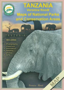
 Tanzania: Veronica Roodt Maps of National Parks and Conservation Areas
 Serengeti National Park
 Kenya – Serengeti Nelles
 Animals of the Serengeti: And Ngorongoro Conservation Area
 Zambia Road Map
 Serengeti – Masai-Mara – Ngorongoro – Lake Manyara Safari Handbook
 Birds of the Serengeti: and Ngorongoro Conservation Area
 Botswana Tourist Map
 Moremi Game Reserve
 Serengeti – Endless plains
 Okavango Delta and Linyanti
 Serengeti Spy
 Zimbabwe National Parks Map
 Oman Map & Guide
 Australia Periplus Travel Map
 Vietnam ITMB
 Canada National Parks
 Namibia InfoMap
 Northern Tanzania: Serengeti, Kilimanjaro, Zanzibar Bradt Guide
 Canada National Parks NGS Wall Map PAPER
 Southern Norway North – Oslo – Bergen – Rondvassbu – Galdhopiggen Cappelen Sectional Road Map
 Czech – Slovak Republics F&B Superatlas
 Outback Queensland Hema
 Kaokoland – North Western Namibia InfoMap
 Western Australia Hema
 Sweden Michelin
 Outback Queensland – Camooweal to Stanthorpe Hema Explorer Map
 Thailand Nelles
 Botswana Globetrotter Map
 Iceland Michelin
 South West Western Australia Hema
 Czechia Michelin
 Birdsville and Strzelecki Tracks, SA/QLD/NSW
 Gujarat Map-Guide
 Czechia – Slovakia Michelin
 Austria Michelin
 Andhra Pradesh
 Bangkok Walks Street Plan
 Okinawa & the Ryukyu Islands Periplus Travel Map