Disclosure : This site contains affiliate links to products. We may receive a commission for purchases made through these links.
Schweinfurt Leisure Map D06
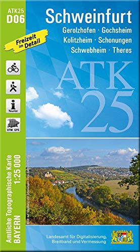
Schweinfurt in a series of GPS compatible recreational editions of the Bavarian topographic survey at 1:25,000, with waymarked hiking trails and cycling routes, campsites and youth hostels, etc. Coverage includes Gerolzhofen, Gochsheim, Kolitzheim, Schonungen, Schwebheim, Theres.Contours used in this map vary between 5 to 20m according to the terrain, with 20m interval predominantly used for hilly areas. Varied colouring show different types of landscape: woods, vineyards, fields etc. Maps in this series feature extensive overprint highlighting local and long-distance footpaths and cycle routes, including King Ludwig Way or different variants of the Way of St James, indicating their waymarking. Symbols highlight different types of accommodation (campsites, youth hostels, refuges, etc), sport and recreational facilities, various places of interest, etc. The maps have a 1-km UTM grid. Map legend and all the text are in German only.To see other titles in this series please click on the series link.

Related Products:
 Franconia Wineland – Wรผrzburg – Schweinfurt UK50-07
 Hauzenberg Leisure Map L20
Hilpoltstein Leisure Map I10
Hauzenberg Leisure Map L20
Hilpoltstein Leisure Map I10
 Bad Kotzting Leisure Map I16
 Hemau Leisure Map I12
 Eichendorf Leisure Map L17
 Trostberg Leisure Map O15
 Passau Leisure Map L19
 Massbach Leisure Map C06
 Weidenberg Leisure Map D12
 Heilsbronn Leisure Map H08
 Tittmoning Leisure Map O16
 Weissenburg Leisure Map I09
 Vilshofen an der Donau Leisure Map L18
 Munchberg Leisure Map C12
 Neumarkt Sankt Veit Leisure Map M15
Pottmes L09
Aichach M09
Ansbach H07
Markt Erlbach G07
Neumarkt Sankt Veit Leisure Map M15
Pottmes L09
Aichach M09
Ansbach H07
Markt Erlbach G07
 Velburg H12
Mauth
Velburg H12
Mauth
 Germany: Bavarian 50K Topographic Survey Leisure Maps
 Thannhausen
Sonthofen
Oberstdorf
Kulmbach C11
Thannhausen
Sonthofen
Oberstdorf
Kulmbach C11
 Ansbach
 Pottmes
 Aichach
 Viechtach
Geiselhoring
Viechtach
Geiselhoring
 Ruhpolding Q16
Vilseck F12
Pleystein F15
Bad Rodach B08
Denkendorf J11
Ruhpolding Q16
Vilseck F12
Pleystein F15
Bad Rodach B08
Denkendorf J11
 Bad Kissingen
 Mering
Ammersee
Mering
Ammersee