Disclosure : This site contains affiliate links to products. We may receive a commission for purchases made through these links.
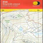
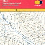
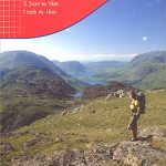
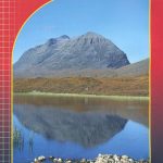
Scafell Summit Map

The summit of Scafell on a handy size, light, waterproof and tear-resistant map at 1:12,500 from Harvey Map Services, ideal for mountaineering in poor weather conditions. Coverage includes the peaks of Scafell, Scafell Pike, Great End and Lingmell.Each map in the Harvey’s Summit Map series, only 41x30cm when opened and 10x20cm when folded, provides an excellent picture of the terrain through contours at 15m intervals with additional colouring and graphics to show scree, boulder fields, scattered rocks or boulders, and major crags, plus farmland or moorland as well as open or dense woodland and new plantations.Where appropriate, right of way paths are highlighted, and symbols indicate mountain rescue post or kits, youth hostels and campsites, car parks and information points. All the maps have the lines of the British National Grid at 100m intervals.To see the other titles in this series please click on the series link.

Related Products:
 Helvellyn Summit Map
 Ben Nevis Summit Map
 Great Britain: Harvey Summit Maps
 Dartmoor for Cyclists
 The Three Peaks Challenge – Scafell Pike OS Explorer Map
 Scafell & Wasdale CB Centenary Edition
 National Three Peaks Adventure Atlas: Ben Nevis, Scafell Pike, Snowdon
 Gerry Charnley Round in the Lakeland Fells
 MacGillycuddy`s Reeks Harvey Superwalker XT30
 Softfibre OS Map Towel – Scafell Pike
 National 3 Peaks Challenge Minimaps Set: Ben Nevis, Scafell Pike and Snowdon.
 Great Britain: Harvey Maps of Long-distance Hiking Trails
 Lake District Harvey British Mountain Map XT40
 Ben Venue – Loch Ard Forest & the Trossachs Harvey Superwalker
 Ben Nevis & Glen Coe Harvey British Mountain Map XT40
 Walking the Lake District Fells – Borrowdale: Scafell Pike, Catbells, Great Gable and the Derwentwater Fells
 Aconcagua – Summit of South America
 View From The Summit
 Arrochar Alps Harvey Superwalker XT25
 Trotternish – Skye Harvey Superwalker XT25
 Peak District South Harvey Superwalker XT25
 Torridon Harvey Superwalker XT25
Pentland Hills Harvey Ultramap XT40
Torridon Harvey Superwalker XT25
Pentland Hills Harvey Ultramap XT40
 Isle of Man Harvey Superwalker XT30
An Teallach & Fisherfield Harvey Superwalker
Isle of Man Harvey Superwalker XT30
An Teallach & Fisherfield Harvey Superwalker
 Lake District West Harvey Superwalker XT25
 Everest – Summit of the World
 Ben Lawers and Schiehallion Harvey Superwalker XT25
 Pembrokeshire Coast Path Harvey National Trail XT40
 Yorkshire Dales South East Harvey Superwalker XT25
Yorkshire Dales South West Harvey Superwalker XT25
Yorkshire Dales South East Harvey Superwalker XT25
Yorkshire Dales South West Harvey Superwalker XT25
 Two Moors Way Harvey National Trail XT40
 Ochil Hills Harvey Superwalker XT25
Ben Lawers & Schiehallion Harvey Ultramap XT40
Yorkshire Dales South East Harvey Ultramap XT40
Cadair Idris – Snowdonia / Eryri Harvey Superwalker
Snowdonia North Harvey Ultramap XT40
Ochil Hills Harvey Superwalker XT25
Ben Lawers & Schiehallion Harvey Ultramap XT40
Yorkshire Dales South East Harvey Ultramap XT40
Cadair Idris – Snowdonia / Eryri Harvey Superwalker
Snowdonia North Harvey Ultramap XT40