Disclosure : This site contains affiliate links to products. We may receive a commission for purchases made through these links.
Sant Joan de Labritja CNIG Topo 773
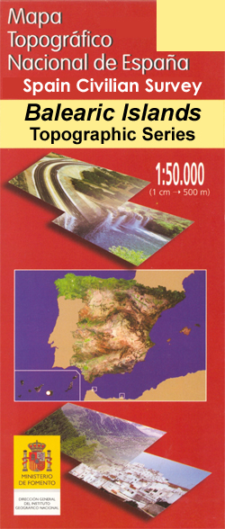
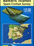
Topographic coverage of the Balearic Islands at 1:50,000 in the MTN50 (Mapa Topogrรกfico Nacional) series from the Instituto Geogrรกfico Nacional ‘“ Centro Nacional de Informaciรณn Geografica, the country’s civilian survey organization. The maps have contours at 20m intervals, enhanced by relief shading, plus colouring and/or graphics to show different types of terrain, vegetation or land use. Boundaries of national parks and other protected areas are marked. In addition to all the usual information featured on topographic mapping at this scale: detailed presentation of the road and rail networks, rural tracks and paths, etc, the maps also show campsites and mountain refuges. On more recent editions some GRs, the official long-distance hiking routes, are also marked (although not as clearly as on hiking maps from other publishers). The MTN50 series was begun in late 1990s. Each map covers 28.5×18.5 km (with adjustments in the coastal areas). The maps have a 1-km UTM grid, plus margin ticks for latitude and longitude at 1` intervals. Map legend is in Spanish only.To see other titles in this series please click on the series link.

Related Products:
 Horta de Sant Joan CNIG Topo 496
 Sant Joan de Labritja 25K Ibiza CNIG Topographic Survey Map No. 773-III
 Sant Miguel de Balansat CNIG Topo 722
 Sant Llorenรง de Morunys CNIG Topo 292
Andraitx CNIG Topo 697
Inca CNIG Topo 671
Porreres CNIG Topo 699
Macanor CNIG Topo 700
Alaior CNIG Topo 646
Palma CNIG Topo 698
Ila de Cabrera CNIG Topo 774
Sa Calobra CNIG Topo 643
Cap de Formentor CNIG Topo 645
Soller CNIG Topo 670
Arta CNIG Topo 672
Mahon / Mao CNIG Topo 647
Formentera CNIG Topo 824/825/849
Son Parc CNIG Topo 619
Cap Menorca y Ciutadella CNIG Topo 618
Llucmajor CNIG Topo 724
Eivissa CNIG Topo 798
Felanitx CNIG Topo 725
Santa Eularia des Riu CNIG Topo 799
Illa de L`Aire CNIG Topo 673
Pollensa / Polenรงa CNIG Topo 644
Illa del Toro y Cap de Cala Figuera CNIG Topo 723
Isla Conejera / Illa des Conills CNIG Topo 748
Roa CNIG Topo 345
Foz CNIG Topo 9
Sant Llorenรง de Morunys CNIG Topo 292
Andraitx CNIG Topo 697
Inca CNIG Topo 671
Porreres CNIG Topo 699
Macanor CNIG Topo 700
Alaior CNIG Topo 646
Palma CNIG Topo 698
Ila de Cabrera CNIG Topo 774
Sa Calobra CNIG Topo 643
Cap de Formentor CNIG Topo 645
Soller CNIG Topo 670
Arta CNIG Topo 672
Mahon / Mao CNIG Topo 647
Formentera CNIG Topo 824/825/849
Son Parc CNIG Topo 619
Cap Menorca y Ciutadella CNIG Topo 618
Llucmajor CNIG Topo 724
Eivissa CNIG Topo 798
Felanitx CNIG Topo 725
Santa Eularia des Riu CNIG Topo 799
Illa de L`Aire CNIG Topo 673
Pollensa / Polenรงa CNIG Topo 644
Illa del Toro y Cap de Cala Figuera CNIG Topo 723
Isla Conejera / Illa des Conills CNIG Topo 748
Roa CNIG Topo 345
Foz CNIG Topo 9
 Ibi CNIG Topo 846
Coy CNIG Topo 932
Vic CNIG Topo 332
Used CNIG Topo 464
Tui CNIG Topo 260/261
Boรฑar CNIG Topo 104
Orduรฑa CNIG Topo 111
A Gudiรฑa CNIG Topo 266
Leรณn CNIG Topo 161
La Baรฑa CNIG Topo 229
Ibi CNIG Topo 846
Coy CNIG Topo 932
Vic CNIG Topo 332
Used CNIG Topo 464
Tui CNIG Topo 260/261
Boรฑar CNIG Topo 104
Orduรฑa CNIG Topo 111
A Gudiรฑa CNIG Topo 266
Leรณn CNIG Topo 161
La Baรฑa CNIG Topo 229
 Oรฑa CNIG Topo 136