Disclosure : This site contains affiliate links to products. We may receive a commission for purchases made through these links.
San Juan Islands WA
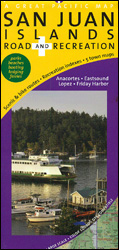
San Juan Islands Road and Recreation Map at 1:70,000 from the Great Pacific Recreation & Travel Maps highlighting recommended cycling routes, with town maps and very extensive tourist information about recreational facilities, places of interest, transport, etc.The map presents the islands with altitude colouring to show their topography. Moran State Park and other protected areas are marked. Along the coast beaches or mud flat and rocky shoreline are indicated. The map shows recommended cycle and mountain bike routes, indicating gradients and roads where extra caution is advisable. Symbols mark campgrounds, picnic areas, public breaches, fishing access, marinas, wineries, petrol stations, etc. The map has an extensive index of roads, islands and other geographical features.Enlargements cover Friday Harbor with a detailed street plan of the downtown area, Lopez Village and vicinity and Eastsound, as well as Anacortes and Skyline with ferry terminal for San Juan Islands.Numerous information panels provide very extensive lists of additional tourist information: ferry services, accommodation, campgrounds, beaches, parks and recreation areas, cycle and moped rentals, marinas and anchorages, museums and historic places, etc. Where appropriate, phone numbers or website addresses are included.

Related Products:
 Dalmatian Coast 1 – Zadar – Kornati Islands F&B
 Rio San Juan: Nicaragua – Costa Rica Border Regions
 Moon San Juan Islands (Sixth Edition): Best Hikes, Local Spots, and Weekend Getaways
 Minor Cyclades Islands: Heraklia, Schinousa, Keros, Koufonisia, Donoussa Terrain Editions 312
 West Frisian Islands Falkplan Cycling Map
 Zeeland Islands with Zeelandic Flanders Falkplan Cycling Map 16
 The Islands of Croatia: 30 Walking Routes on 14 Adriatic Islands
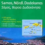 Samos & Northern Dodecanese Islands 50K Kompass Map No.253
 South San Juan – Del Norte CO
 A Cruising Guide to Puget Sound and the San Juan Islands
 Greece: Terrain Editions Maps of the Greek Islands
 Boston Harbor Islands National Recreation Area MA
 Aeolian (Lipari) Islands and Southern Italy F&B
 Orkney – Shetland Islands Leisure and Tourist Map
 Balearic Islands Michelin Regional 579
 The Aran Islands OSI Adventure Map – including Souvenir OS Map Aran Islands 1838
 South East Lewis – Loch Eireasort & Shiant Islands OS Explorer Map 457 (paper)
 Papua New Guinea – Indonesian Papua & Maluku Islands Reise Know-How
 South East Lewis – Loch Eireasort & Shiant Islands OS Explorer Active Map 457 (waterproof)
 Puget Sound and Greater Seattle, WA
 San Juan de Puntallana – La Palma CNIG Topo 1083-4
 Denmark Tourist Map – Major Cities with the Marguerite Route
 Cape Verde Islands F&B
 Pennsylvania Recreation Atlas
 Virgin Islands (US and British)
 Kos – Southern Dodecanese Kompass 252
 Hawaiian Islands Borch
 USA: Great Pacific Recreation & Travel Maps of the Pacific Northwest
 Istria Reise Know-How
 Stockholm County Norstedts Road Map
 Canary Islands
 Virgin Islands (US and British) ITMB
 New Zealand F&B
 Hawaiian Islands
 Marco Island – Ten Thousand Islands FL
 Caribbean Islands Western Half ITMB Travel Atlas
 Virgin Islands Borch
 Lofoten and Vesteralen Islands
 Canary Islands Michelin Zoom 125
Torre del Juan Abad CNIG Topo 839
Canary Islands Michelin Zoom 125
Torre del Juan Abad CNIG Topo 839