Disclosure : This site contains affiliate links to products. We may receive a commission for purchases made through these links.
Samokov – Borovets with the Rila Mountains
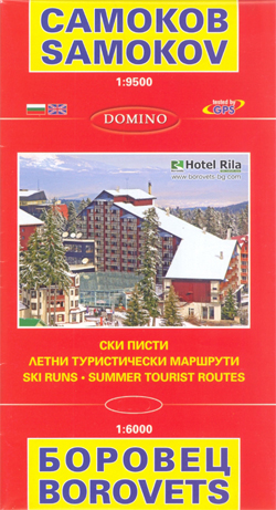
Street plans of Samokov and Borovets, plus a contoured map of part of the Rila National Park showing waymarked hiking routes, a panorama map with ski runs in Borovets, and English langugage information on hotels, etc.On one side is a street plan of Samokov at 1:9,500 annotated with symbols showing various facilities. Street names are in Cyrillic, with main ones also in Latin alphabet. Street index is in Cyryllic only. Map legend and accompanying notes about the town, plus an extensive directory of various services including hotels, restautants, etc, all include English.On the reverse is a street plan of Borovets at 1:6,000 showing locations of the resort’s various tourist facilities, cable and chair lift stations, etc. Also provided is a detailed contoured map at 1:40,000 of the surrounding area including the northern part of the Rila National Park. The map highlights waymarked hiking routes, mountain shelters, etc. A panorama map show ski runs on the slopes south of Borovets, grading the routes according the degree of difficulty. Also included is a list of hotels in Borovets. Map legends and all the text include English.


