Disclosure : This site contains affiliate links to products. We may receive a commission for purchases made through these links.
Sale South-West 1908
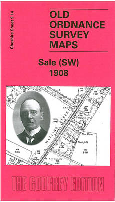
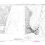
Sale South-West in 1908 in a fascinating series of reproductions of old Ordnance Survey plans in the Alan Godfrey Editions, ideal for anyone interested in the history of their neighbourhood or family. SThe map covers the south-western area of Sale along Washway Road, the old Watling Street. It is a semi-rural map but features include tramways, Haddon House, Tyntesfield, Woodheys Hall, Washway Farm, Manor House, Brookside Farm, Bridgewater Canal, stretch of railway with part of Brooklands station at east margin of map, Sale Cemetery (at top of map), etc. On the reverse are street directory entries for Washway Road. About the Alan Godfrey Editions of the 25″ OS Series:Selected towns in Great Britain and Ireland are covered by maps showing the extent of urban development in the last decades of the 19th and early 20th century. The plans have been taken from the Ordnance Survey mapping and reprinted at about 15 inches to one mile (1:4,340). On the reverse most maps have historical notes and many also include extracts from contemporary directories. Most maps cover about one mile (1.6kms) north/south, one and a half miles (2.4kms) across; adjoining sheets can be combined to provide wider coverage.FOR MORE INFORMATION AND A COMPLETE LIST OF ALL AVAILABLE TITLES PLEASE CLICK ON THE SERIES LINK.

Related Products:
 Knutsford South 1908
 Beverley South 1908
 Worcester South-West 1902
 Uckfield 1908
 St Albans South-West 1897
 West Drayton South 1935
 Rochdale West 1908
Ashton-on-Mersey 1927
Anfield 1908 – 106.07b
Colwyn Bay South West 1911
South Yardley and Hay Mills 1903
Barnsley South 1904
Northfield South 1903
Harborne South 1901
Rochdale West 1908
Ashton-on-Mersey 1927
Anfield 1908 – 106.07b
Colwyn Bay South West 1911
South Yardley and Hay Mills 1903
Barnsley South 1904
Northfield South 1903
Harborne South 1901
 Brough 1908
Maldon West 1920 – 55.16
Knutsford North 1908
Brough 1908
Maldon West 1920 – 55.16
Knutsford North 1908
 South Croydon 1895 – 14.14
 South Croydon 1895 – 159.2
 Sedgley South-East with Swan Village and West Coseley 1901
Carlisle South-West 1924
Swindon South-West 1899
Sedgley South-East with Swan Village and West Coseley 1901
Carlisle South-West 1924
Swindon South-West 1899
 South Norwood 1895
Wigan West 1908
South Norwood 1895
Wigan West 1908
 Altrincham 1908
Dun Laoghaire 1908
Altrincham 1908
Dun Laoghaire 1908
 Loughton (South) 1895 – 57.16
Enfield (South) 1895 – 7.07a
Leicester South West 1902-1911
Sunderland South 1895
Farington South and Leyland North 1909
Trafford Park South 1937
Loughton (South) 1895 – 57.16
Enfield (South) 1895 – 7.07a
Leicester South West 1902-1911
Sunderland South 1895
Farington South and Leyland North 1909
Trafford Park South 1937
 Shrewsbury West 1900
 Hull North East 1908
 Darlington (South) 1898 – 55.10a
Stourbridge South and Oldswinford 1914
Darlington (South) 1898 – 55.10a
Stourbridge South and Oldswinford 1914
 Warwick (South) 1923
Halifax South West and Sowerby Bridge 1892
Darlington West 1898
Warwick (South) 1923
Halifax South West and Sowerby Bridge 1892
Darlington West 1898