Disclosure : This site contains affiliate links to products. We may receive a commission for purchases made through these links.
Ryfylke Nordeca Tourist Route 20002

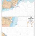
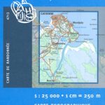
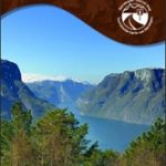
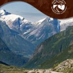
This Ryfylke National Tourist Route Map belongs to a series of 18 map and postcards sets describing popular tourist routes all over Norway. The map set includes a map in 1:105,000 presenting an accurate topography (based on the Norwegian topographic survey) which describes local footpaths, cycle or ski routes, sport and recreational facilities, places of interest, places to stay and eat, viewpoints.Ryfylke is a sheltered fjord region, located northeast of Stavanger and east of Haugesund. Ryfylke National Tourist Route is a 183-kilometre-long stretch of road between Oanes by the Lysefjord to Hordalia in Rรธldal, in the county of Rogaland in Fjord Norway. Along Ryfylke National Tourist Route you pass villages, towns and cultural attractions like old industrial buildings and the abandoned 19th century zinc mines at Allmannajuvet. The melting plants in Sauda, deep amid the mountains and waterfalls of Ryfylke, offer a good starting point for a trip through Norwegian industrial history. A detour south from the road brings the traveller to Preikestolen Mountain Lodge, from which a prepared path goes up to the famous Preikestolen (the Pulpit Rock) with its magnificent view over the Lysefjord. As you travel the scenic road you will discover picnic areas set in beautiful surroundings, and cultural monuments that are centuries or even thousands of years old.There are two panoramic view and rest areas: Ropeid, which is a ferry landing with service building, and Svandalsfossen, a parking lot with steps along the Svandalsfossen Waterfall. The waterfall is a well-known attraction in Sauda, and a magnificent view when the river runs high.The set features:One map: scale 1:105,000 Text in three languages (Norwegian, English and German)5 Postcards (13.5x25cm)To see the list of other titles in this series, please click on the series link.

Related Products:
 Aurlandsfjellet Nordeca Tourist Route 20005
 Old Strynefjellsvegen Nordeca Tourist Route 20009
 Sognefjellet Nordeca Tourist Route 20008
 Gaularfjellet Nordeca Tourist Route 20007
 Havoysund Nordeca Tourist Route 20017
 Valdresflye Nordeca Tourist Route 20006
 Atlantic Road Nordeca Tourist Route 20012
 Varanger Nordeca Tourist Route 20018
 Helgeland Coast North Nordeca Tourist Route 20013
 Indre Ryfylke Nordeca 2790
 Lofoten Nordeca Tourist Route 20014
 Garden Route & Route 62 Map Studio
Denmark Tourist Map – Major Cities with the Marguerite Route
Garden Route & Route 62 Map Studio
Denmark Tourist Map – Major Cities with the Marguerite Route
 Bloemfontein Pocket Tourist Map
 Inner Oslofjord Nordeca Watersport 5200
 Port Elizabeth Pocket Tourist Map
Ypres Salient: Tourist Car Route 1914-1918
Port Elizabeth Pocket Tourist Map
Ypres Salient: Tourist Car Route 1914-1918
 Stromberg-Murrtal Cycle Route – Idyllic Route
Glan-Blies Route – Barbarossa Route – incl Lauertal Route Bikeline Map-Guide Compact
Stromberg-Murrtal Cycle Route – Idyllic Route
Glan-Blies Route – Barbarossa Route – incl Lauertal Route Bikeline Map-Guide Compact
 International Dollard Route – German Fehn Route Bikeline Map-Guide
 The Coastal Route Nordeca Sightseeing Map 6009
 Etruscan Coast – Pisa – Livorno – Piombino Global Map Tourist Map
 Norway: Nordeca Regional Touring Maps
 Spain North – Santiago Route Reise Know-How
 Munich-Venice Long Distance Cycle Route – incl Dolomites Route Bikeline Map-Guide
 The Salmon Run – Dundee to Pitlochry Cycle Route
 Iller Cycle Route – Zusam Cycle Route Bikeline Map-Guide
 The Coastal Route Nordeca Sightseeing Map 6029
Danube-Lake Constance Cycle Route – Upper Swabia-Allgรคu Cycle Route Bikeline Map-Guide
The Coastal Route Nordeca Sightseeing Map 6029
Danube-Lake Constance Cycle Route – Upper Swabia-Allgรคu Cycle Route Bikeline Map-Guide
 Folgefonna National Park Nordeca 2663
 Sea to Sea Cycle Route: Whitehaven/Workington – Newcastle/Sunderland
 The Route of the Thousand Kasbahs – Cultural Map of Southern Morocco
 Devon Coast to Coast – Route 27 Cycle Map 66
 France Michelin Tourist & Motoring Atlas 2021 MULTIFLEX
 Route of Industrial Heritage through the Ruhr by Bike
 Lรดn Las Cymru Cycle Route North: Holyhead – Llanidloes
 Coast & Castles Cycle Route North: Edinburgh – Aberdeen
Ruhr Valley Cycle Route – Sauerland to the Rhine Bikeline Map-Guide
Maremma – Grossetana Global Map Tourist Map
Coast & Castles Cycle Route North: Edinburgh – Aberdeen
Ruhr Valley Cycle Route – Sauerland to the Rhine Bikeline Map-Guide
Maremma – Grossetana Global Map Tourist Map
 The North West Trail Cycle Route