Disclosure : This site contains affiliate links to products. We may receive a commission for purchases made through these links.
Roeselare NGI Topo 19-20 – WWI Ypres Salient Battlefields
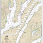
Roeselare, map No. 19-20 in the topographic survey of Belgium at 1:50,000 covering the northern sector of the Ypres Salient battleground of World War I, north of the Paschendaele/Passendale ‘“ Boezinge line, including Steenstraat. Map legend includes English.Although not specifically designed to highlight locations connected with WWI, the map contains all the information expected of detailed topographic mapping at this scale and provides excellent background for exploring the area with more specialist maps or guides. For full specifications of Belgian topographic mapping at 1:50,000 and a list of titles in this series please click on the series link.PLEASE NOTE: Coverage at 1:50,000 of the bulk of the Ypres Salient battleground is provided by sheet No. 27-28-36, Ieper. More detailed topographic coverage of the whole area by the Belgian survey is also available at 1:20,000.

Related Products:
 Ieper NGI Topo 27-28-36 – WWI Ypres Salient Battlefields
 Lo-Reninge NGI Topo 20/5-6 – WWI Ypres Salient Battlefields
 Ieper NGI Topo 28/1-2 – WWI Ypres Salient Battlefields
 Zonnebeke NGI Topo 28/3-4 – WWI Ypres Salient Battlefields
 Heuvelland NGI Topo 28/5-6 – WWI Ypres Salient Battlefields
 Mons NGI Topo 45 – WWI Battlefields
 Le Bizet NGI Topo 36/1-2
 Silent Cities of Flanders Fields: WWI Cemeteries of Ypres Salient and West Flanders (2-book set)
 Ypres Salient Fir Tree Aerial Map
 Ypres Salient: Tourist Car Route 1914-1918
 Understanding the Ypres Salient: An Illuminating Battlefield Guide
 In The Ypres Salient: The Story Of A Fortnight`s Canadian Fighting
 Ypres Salient Battlefield Guide
 WWI Trench Map: Ypres (28 NW – ed. 4A)
 Nivelles NGI Topo 39 – Battle of Waterloo Area
 Roeselare NGI Topo 20/7-8
 Waterloo – Lasne: Battle of Waterloo Area 20K NGI Belgium Survey Map No. 39/3-4
 Nivelles – Genappe: Battle of Waterloo Area 20K NGI Belgium Survey Map No. 39/7-8
 Visiting the Somme and Ypres Battlefields Made Easy: A Helpful Guide Book for Groups and Individuals
 Passchendaele: The Story of the Third Battle of Ypres 1917
 Pocket Battlefield Guide to Ypres and Passchendaele
 Ypres in War and Peace
 Mapping the First World War: Battlefields of the Great Conflict from Above
 The Western Front
 Pass Guard at Ypres
 Wavre NGI Topo 40
 Mechelen NGI Topo 23
Bouillon NGI Topo 67-70
Mechelen NGI Topo 23
Bouillon NGI Topo 67-70
 Tielt NGI Topo 21
 Lier NGI Topo 16
 Brasschaat NGI Topo 1-7
 Thuin NGI Topo 52
Saint-Hubert NGI Topo 59
Thuin NGI Topo 52
Saint-Hubert NGI Topo 59
 Dinant NGI Topo 53
 Mol NGI Topo 17/1-2
 Ath NGI Topo 38/5-6
 Arlon NGI Topo 68-69
 Mettet NGI Topo 53/1-2
 Lierneux NGI Topo 55/3-4
 Aubange NGI Topo 71/3-4