Disclosure : This site contains affiliate links to products. We may receive a commission for purchases made through these links.
Rio Verde – Laguna Blanca SIG Patagon
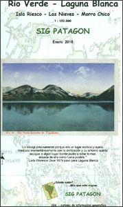
Rio Verde – Laguna Blanca area of the Chilean Patagonia on a double-sided, contoured and GPS-compatible map from SIG Patagon. One side at 1:185,000 is centred on Laguna Blanca and extending north to Morro Chico and south in to the northern part of Seno Otway and Reten Kon Aitken at the foot of the Brunswick Peninsula. The map shows local roads and tracks and symbols indicate locations with tourist facilities, sites for trekking and watching local fauna, etc. On the reverse, a map at 1:210,000 extends coverage further west of Laguna Blanca along the Seno Skyring to approx. 72ยบ45’W. Both sides have a UTM grid, plus latitude and longitude margin ticks at 30’. Map legend is in Spanish only. To see other titles in this series please click on the series link.

Related Products:
 Antuco – Laguna del Laja National Park
 Tierra del Fuego – Cordillera Darwin – Lago Fagnano – Isla Navarino SIG Patagon
 Laguna del Maule – Winter Trails
 Cordillera Blanca North Alpenverein 0/3A
 Punta Arenas – Peninsula de Brunswick SIG Patagon
 Cordillera Blanca South Alpenverein 0/3B
 Torres del Paine – Puerto Natales – Sierra Baguales SIG Patagon
 Huaraz, Peru – Cordillera Blanca & Huayhuash Tourist Map
 The Lighthouse Trail in Sierra Blanca
 La Laguna Negra ‘“ Picos de Urbiรณn
 SEMAR Chart 813.3 – Laguna Verde, Veracruz
 Roca Espana: Costa Blanca Sud
 Costa Blanca RockFax
 Chile: SIG Patagon Exploration and Trekking Maps
 Peru`s Cordilleras Blanca & Huayhuash – The Hiking & Biking Guide
 San Cristobal de la Laguna CNIG Topo 1088
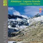 Sierra de Gredos – Almanzor – Laguna Grande Editorial Alpina
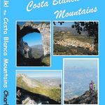
 Costa Blanca Mountains Super-Durable Map
 SEMAR Chart 842.2 – Laguna de Terminos, West entrance
 Playa Blanca CNIG Topo 1084-1/2
 Costa Blanca – Valencia – Alicante – Castellon – Murcia Marco Polo Map
 Alqueria Blanca 25K Mallorca CNIG Topographic Survey Map No. 725-III
Playa Blanca CNIG Topo 1084
Alqueria Blanca 25K Mallorca CNIG Topographic Survey Map No. 725-III
Playa Blanca CNIG Topo 1084
 Laguna de Tirez CNIG Topo 687-3
Laguna Dalga CNIG Topo 232-1
Laguna de Negrillos CNIG Topo 232-4
Laguna de Cameros CNIG Topo 241-4
Costa Blanca Editorial Alpina Cycle Map
Laguna de Tirez CNIG Topo 687-3
Laguna Dalga CNIG Topo 232-1
Laguna de Negrillos CNIG Topo 232-4
Laguna de Cameros CNIG Topo 241-4
Costa Blanca Editorial Alpina Cycle Map
 Walk! Costa Blanca Mountains
 DK Eyewitness Top 10 Costa Blanca
 Walking on the Costa Blanca
 Costa Blanca Sunflower Landscape Guide
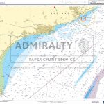
 Admiralty Chart 55 – Laguna de Chiriqui
 North Costa Blanca Road Cycle Map
 Costa Blanca Michelin Zoom 123
SEMAR Chart 631.3 – Laguna Mar Muerto
Costa Blanca Michelin Zoom 123
SEMAR Chart 631.3 – Laguna Mar Muerto
 Costa Blanca Marco Polo Pocket Travel Guide 2019 – with pull out map
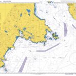
 Admiralty Chart 1936 – Puerto de Laguna de Cuyutlan ( Manzanillo LNG terminal)
 SEMAR Chart 842 – Laguna Pom a Santa Cruz