Disclosure : This site contains affiliate links to products. We may receive a commission for purchases made through these links.
Rheinsteig long-distance Trail Kompass 2503
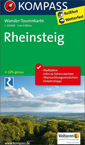
The Rheinsteig, a 306km long-distance hiking trail from Bonn to Wiesbaden along the right bank of the Rhine, including a 65km stretch of the Middle Rhine Valley, a UNESCO World Heritage area and home to many castles, historic towns and vineyards which have inspiration for many writers, artists and composers. The route is presented on 16 panels, accompanied by street plans of central Bonn, Koblenz, Rรผdesheim am Rhein and Wiesbaden.Maps in this new series from Kompass, begun in summer 2014, are at 1:50,000, contoured and GPS compatible, and printed on sturdy but light waterproof and tear-resistant synthetic paper. Each route is prominently highlighted on a series of 17.5 x 20cm panels and annotated with 5km markers. Topography is shown by contours (intervals at 20m or 40m) enhanced by relief shading with colouring and/or graphics for woodlands, orchards, vineyards, etc. Symbols indicate various accommodation options (hotels, campsites, youth hostels), sport facilities, and various places of interest. The maps also show locations of car parks near the route and railway lines are shown with stations. The maps have a 2km UTM grid. Each title includes street plans of local towns, a route profile, details of recommended accommodation indicating price range, plus descriptions of main places of interest. Map legend and all the text are in German only.To see other titles in this series please click on the series link.

Related Products:
 Eifelsteig long-distance Trail Kompass 2502
 Hermannsweg und Eggeweg – die Hermannshohen Kompass Long-distance Trail Map 2504
 Sieg River Long-distance Trail
Germany and Alpine Regions of Europe: Kompass Maps of Long-distance Footpaths
Sieg River Long-distance Trail
Germany and Alpine Regions of Europe: Kompass Maps of Long-distance Footpaths
 Hermannsweg & Eggeweg Long-distance Trail: Teutoburger Wald – Eggegebirge
 Lake Constance to Verona – E5 European Long-Distance Trail Kompass 2558
 SalzAlpenSteig: Chiemsee – Kรถnigssee -Halstรคtter See
 Rhine Cycle Route 3 – Mainz to Duisburg Bikeline Map-Guide
 Rhine Cycle Route 4 – Cologne to Hoek van Holland Bikeline Map-Guide
 Hungarian National Long-distance Blue Trail (E7): Irott-ko to Szekszard
Trans-Alpine Crossing – Tegernsee – Achensee – Zillertal – Sterzing Kompass 2556
Hungarian National Long-distance Blue Trail (E7): Irott-ko to Szekszard
Trans-Alpine Crossing – Tegernsee – Achensee – Zillertal – Sterzing Kompass 2556
 Hawaii – Kauai Nelles
Hungarian National Long-distance Blue Trail (E4): Visegrad to Irott-ko
Hawaii – Kauai Nelles
Hungarian National Long-distance Blue Trail (E4): Visegrad to Irott-ko
 Rhine-Main – Frankfurt – Aschaffenburg – Darmstadt – Mainz – Wiesbaden ADAC Street Atlas
 The Rhรดne to the Rhine Canal
 Mozart Bike Trail F&B RK3
 Transrhodopi – Long distance hiking and biking trail From Trigrad to Ivaylovgrad
 Munich-Venice Long Distance Cycle Route – incl Dolomites Route Bikeline Map-Guide
 Tour du Mont Blanc: The most iconic long-distance, circular trail in the Alps with customised itinerary planning for walkers, trekkers, fastpackers and trail runners
 Lahn Valley Cycle Route – from Source to Rhine Bikeline Map-Guide
 Rhine Cycle Route 1 – Andermatt to Basel
 Moselle Cycle Route: Metz to the Rhine (310km) Bikeline Map/Guide ENGLISH Ed.
 Inn Bike Trail: Landeck – Passau Freytag & Berndt Map
 Kamp – Thaya – March Bike Trail Freytag & Berndt Map
Nahe Cycle Route – from Source to the Rhine Bikeline Map-Guide
Kamp – Thaya – March Bike Trail Freytag & Berndt Map
Nahe Cycle Route – from Source to the Rhine Bikeline Map-Guide
 Tauern Bike Trail: Krimml – Passau Freytag & Berndt Map
 Nahe Cycle Route: From the Source to the Rhine at Bingen (123km) Bikeline Map/Guide
Ruhr Valley Cycle Route – Sauerland to the Rhine Bikeline Map-Guide
Nahe Cycle Route: From the Source to the Rhine at Bingen (123km) Bikeline Map/Guide
Ruhr Valley Cycle Route – Sauerland to the Rhine Bikeline Map-Guide
 EuroVelo 6 Cycle Trail: Basel to Budapest
Europe: Bikeline Map/Guides of Long-distance Cycling Routes
EuroVelo 6 Cycle Trail: Basel to Budapest
Europe: Bikeline Map/Guides of Long-distance Cycling Routes
 North Rhine-Westphalia Central/South – Hesse Northwest 2-Map Cycling Set Kompass 3706
 Peaks of the Balkans Long-Distance Hiking Trail: Albania ‘“ Kosovo ‘“ Montenegro
 Tyrol Mountain Bike Trail (1000km) Bikeline Atlas
 Bali Periplus Travel Map
Garden Route & Route 62 Map Studio
Rheinsteig 1 – Bonn – Lahnstein Publicpress Hiking 466
Bali Periplus Travel Map
Garden Route & Route 62 Map Studio
Rheinsteig 1 – Bonn – Lahnstein Publicpress Hiking 466
 Roman Border (Limes) Cycle Route: the Rhine to the Danube (816km) Bikeline Map/Guide
 Lower Saxony West – North Rhine-Westphalia North 2-Map Cycling Set Kompass 3704
 Green Route Cycle Trail: Dรผren – Aachen – Dutch Limburg – Beringen in Flanders (360km) Bikeline Map/Guide
 Elbe Cycle Trail Part 2: Magdeburg – Cuxhaven (500km) Bikeline Map/Guide ENGLISH Ed.