Disclosure : This site contains affiliate links to products. We may receive a commission for purchases made through these links.
Rara to Khaptad
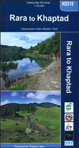
Trekking routes in Nepal west of Jumla on a contoured and GPS-compatible map at 1:150,000 from Nepa Maps. Coverage extends westwards from Jumla, Rara Lake and the Rara National Park to Silgadhi and Dipayal. The trail from Rara Lake westwards to the Khaptad Camp, Khaptad National Park and then north to Tamil is prominently highlighted, with other trekking routes in the region also clearly marked.The map has contours at 80m intervals, enhanced by relief shading and colouring/graphics to show forested areas, cultivated land, etc. Main trekking trails are highlighted, as are important settlements and locations with tourist accommodation including campsites, medical facilities, banks and internet cafes, religious sites, etc. Latitude and longitude are shown by margin ticks at 5’ intervals. The index lists places, passes and lakes. Map legend includes English.To see other titles in this series please click in the series link.

Related Products:
 Dunai to Jumla and Rara Lake
 Nepal`s Far West – Api & Saipal Himal – Khaptad & Rapa NP – Humla Great Himayala Trail Map
 Jumla/Rara – Saipal – Sisne Himal – Gorakh Himal
 Dolpo & Mugu – Phoksumdo – Chharka Bhot – Kanjirowa Himal Great Himalaya Trail Map
 Pokhara City – Lake Side Valley
 Dolpo Circuit
 Shivapuri Nagarjun National Park
 Shorong – Hinku
 Banff – Egypt Lake Gem Trek
 Aukstaitija National Park
 Lake Como terraQuest Trekking Map
 Khumbu – Sagarmatha National Park
 Turkey`s Highest Peaks – Mount Ararat – Kackar Mountains – Mount Suphan terraQuest Trekking Map
 Slowinski National Park ExpressMap Tourist Map
 Nepal Nelles
 Tumlingtar to Lukla
 Lake Taupo
 Karakoram – K2 – Gasherbrum – Broad Peak terraQuest Trekking Map
 Lake Garda terraQuest Trekking Map
 Discover Cairngorms National Park
Kathmandu Valley
Discover Cairngorms National Park
Kathmandu Valley
 Kailas – Manasarovar
 Torres del Paine Trekking Map
 East Devon – Exeter Cycling Map 85
 Helambu Trail
 Cabaรฑeros National Park CNIG Map-Guide SPANISH
 Skadar Lake National Park
 Aconcagua Climbing and Trekking Map
 Wapusk National Park, Manitoba
Sirimilik National Park, Nunavut
Ukkusiksalik National Park, Nunavut
Vuntut National Park, Yukon
Ivvavik National Park, Yukon
Wapusk National Park, Manitoba
Sirimilik National Park, Nunavut
Ukkusiksalik National Park, Nunavut
Vuntut National Park, Yukon
Ivvavik National Park, Yukon
 Ama Dablam
 Pucon – Villarrrica NP – Huerquehue NP
 Waikaremoana – Te Urewera NewTopo Walking Map
 Khumbu Himal Schneider Nepal Map 02
 Kaszuby – Kashubian Landscape Park ExpressMap Tourist Map
Quttinirpaaq NP NU
Kaszuby – Kashubian Landscape Park ExpressMap Tourist Map
Quttinirpaaq NP NU