Disclosure : This site contains affiliate links to products. We may receive a commission for purchases made through these links.
Pyrenees 350K Editorial Alpina Road Map
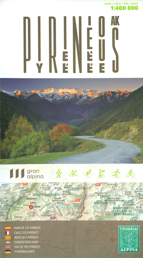
Pyrenees coast to coast and across both sides of the border presented by Editorial Alpina on a map at 1:400,000 with coverage extending from Auch, Toulouse and Bรฉziers in France to Zaragoza, Lleida and Barcelona in Spain; plus panels showing protected areas and the diversity of regional languages.Relief shading and altitude colouring presents the region’s topography, with names of valleys, peaks, passes, etc. National parks and other protected areas are marked. Road network is finely graded, from toll motorways to selected local dirt tracks; driving distances are not shown. Railway lines are included (not always easy to see given the density of place names) but symbols indicate towns with railway stations; also marked are rack railways, cable-car lines and tourist train routes. For cyclists, steep roads are clearly annotated with gradients (both average and highest). The map also shows the course of the regions three main long-distance routes: GR10, GR11 and the Cathars Way. Symbols highlight locations of cultural or nature interest, as well as sites for skiing and water sports. The map has no geographical coordinates. Map legend includes English.Accompanying panels highlight the region’s numerous protected areas and main mountain peaks, plus its diversity of regional dialects including Aranese, Aragonese, Basque, Occitan and Catalan.

Related Products:
 Catalonia Editorial Alpina Road Map
 Canary Islands Autonomous Region 350K CNIG Physical Road Map
 Brittany – Brest – Rennes K+F Regional Road Map
 France: IGN 350K Touring Maps (2016 editions)
 Pyrenees Rando Editions
 Travessa 3 Refugis – Caranรงร – Ulldeter – Coma de Vaca Editorial Alpina
 Pyrenees Reise Know-How
 South Tyrol – Dolomites Tabacco Road and Panorama Map
 Dolomites ‘“ Lake Garda ‘“ Verona – Venice 200K Tabacco Road & Panorama Map
 Aegean Coast / Bati Ege Mepmedya Road Map
 Alt Empordรก 2-Map Set Editorial Alpina
 Manitoba & Saskatchewan MapArt Road Atlas
 North Sea Coast – Bremen – Hamburg K+F Regional Road Map
 Poland: Michelin Regional Road Maps
 Chile Compass Road Map
 Ibiza – Formentera Editorial Alpina
 Catalonia Tourist Road – Regional Divisions Map
 El Cinque Llac Map and Guide Editorial Alpina
 La Alpujarra and La Costa Editorial Penibetica
 Italy North K+F Road Map
 Greece Anavasi Road Map
 Germany: Michelin Regional Road Maps
 Belarus ITMB
 Italy K+F Double-Sided Road Map
Australia Hema Road & Terrain Map
Italy K+F Double-Sided Road Map
Australia Hema Road & Terrain Map
 Bosnia-Herzegovina – Montenegro Reise Know-How
 Melbourne to Adelaide – featuring the Great Ocean Road and Victorian Goldfields Hema Touring Map
 Bulgaria – City Centres Domino Road Map
 Adelaide Hills & Barossa SA
 France Adventure Map
Italy F&B Great Road Atlas SPIRAL-BOUND
Kamchatka & Eastern Siberia ITMB
France Adventure Map
Italy F&B Great Road Atlas SPIRAL-BOUND
Kamchatka & Eastern Siberia ITMB
 Mallorca Central Plain – East and South Coasts Editorial Alpina
 La Alta Ruta de los Perdidos – Monte Perdido – Vignemale Editorial Alpina Hiking Circuit Map
 Crimea Road Atlas
 Ontario MapArt Back Road Atlas
 Caucasus Road Edition Wall Map
 Ripollรจs Editorial Alpina
 Oregon & Northern California Coast Road & Recreation Map