Disclosure : This site contains affiliate links to products. We may receive a commission for purchases made through these links.
Purbeck by Bike
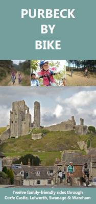
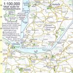
Purbeck area of Dorset on a special cycling map at 1:46,500 from Heritage House highlighting 12 recommended cycle routes presented on the reverse with profiles, grading according to difficulty, etc. The map covers an area extending from the ferry linking Purbeck with Poole westwards beyond Lulworth Cove, and from the coast inland to Briantspuddle and Wareham Forest. Recommended cycle routes are highlighted and other markings indicate byways and bridleways, route numbers of the National Cycle Network, steep hills, danger points, etc. Also clearly marked is the Ministry of Defence Lulworth Ranges danger area. Symbols indicate camping and caravan sites, pubs and restaurants/tearooms, visitor centres, etc. British National Grid is indicated by margin ticks.On the reverse are details and brief descriptions of the 12 recommended cycle routes: distance and time, grading, suitability for children, plus a route profile.

Related Products:
 Bicycle Island – Isle of Wight Heritage House Cycle Map
 Purbeck & South Dorset – Poole, Dorchester – Weymouth & Swanage OS Explorer Map OL15 (paper)
 Purbeck & South Dorset – Poole, Dorchester – Weymouth & Swanage OS Explorer Active Map OL15 (waterproof)
 Bournemouth, Purbeck, Wimborne Minster & Ringwood OS Landranger Map 195 (paper)
 Bournemouth, Purbeck, Wimborne Minster & Ringwood OS Landranger Active Map 195 (waterproof)
 The Isle of Purbeck Guide Book
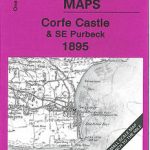 Corfe Castle & SE Purbeck 1895 – 343
 Black Forest South Mountain Bike Guide
 France: Chamina Maps of Long-distance Mountain Bike Routes
 Route of Industrial Heritage through the Ruhr by Bike
 EuroVelo 6 – Danube Bike Trail – Basel to Budapest Cycle Trail 7-Map Set
 Lรดn Las Cymru Cycle Route North: Holyhead – Llanidloes
 Mozart Bike Trail F&B RK3
 Lรดn Cambria & Lรดn Teifi: Mid-Wales Cycle Routes
 Bournemouth and Purbeck 1811
 Vermoshi – Tamare – Razma – Thethi
 Strangford Lough Cycle Trail
 The North West Trail Cycle Route
 The Salmon Run – Dundee to Pitlochry Cycle Route
 South Devon Cycling Map 83
 Boot Up Purbeck
 Inn Bike Trail: Landeck – Passau Freytag & Berndt Map
 Kamp – Thaya – March Bike Trail Freytag & Berndt Map
 Sandstone Way Cycle Route: Berwick-upon-Tweed – Hexham
 Tauern Bike Trail: Krimml – Passau Freytag & Berndt Map
 Great Britain: Mountain Bike Routes UK Guides
 Great Britain: Ordnance Survey Off-Road Cycle Trails
 North Devon Cycling Map 82
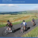
 Sea to Sea Cycle Route: Whitehaven/Workington – Newcastle/Sunderland
 Coast & Castles Cycle Route North: Edinburgh – Aberdeen
 Lanarkshire & Scottish Borders 110K Sustrans Cycle Map No. 38
 Lancashire Sustrans Cycle Map 30
 Ultimate C2C Guide: Sea to Sea by Bike
 Exmoor & Taunton Cycling Map 84
 John O`Groats & North Scottish Coast Cycle Map
 North Cumbria & Dumfries 110K Sustrans Cycle Map No. 35
 Bath to Bournemouth Sustrans Cycle Route Map
 Osogovski National Park
 Shkodra and Environs
 North Northumberland & Scottish Borders Sustrans Cycle Map 39