Disclosure : This site contains affiliate links to products. We may receive a commission for purchases made through these links.
Public Houses Map of Victorian London 1886
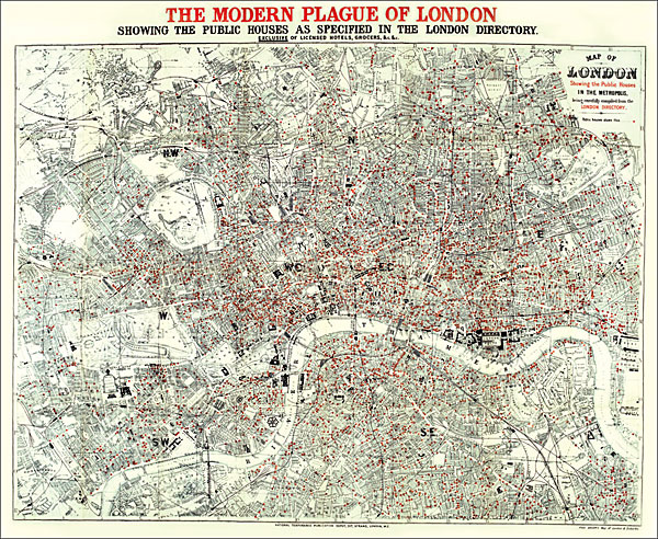
A reproduction from the Old House Books of a map published by the National Temperance Publication Depot around 1886 with a grand title of ‘The Modern Plague of London, showing the public houses as specified in the London Directory. Exclusive of licensed hotels, grocers, &c, &c.”A contemporary street plan of London has an overprint indicating locations of public houses. Not surprisingly, Soho and Covent Garden (where Edward Stanford had already established his printing works in Long Acre, now the location of our shop) have by far the highest density. Coverage extends from Hampstead (surely there must have been pubs there?) and Stoke Newington to Battersea Park and New Cross; and from Holland Park to Victoria Park in Hackney and the western edge of the Isle of Dogs. The map is presented in an elegant card cover with an essay on ‘Drink in Victorian London”.Please note: this title is also available as a wall map.To see other titles in this series please click on the series link.

Related Products:
 London: A New Map of London by Robert Laurie & James Whittle c.1800 MEDIUM
 A New Map Of London c.1800
 London: Robert Sayer`s London Directory Map 1792 MEDIUM
 London: Robert Sayer`s London Directory Map 1792 SMALL
 Cased Dissected Map Stanfords Victorian London Section 3
 London view by Robert Laurie & James Whittle c.1890 SMALL
 Photographing London: 2: Volume 2: Outer London & Secrets of Street Photography
Cased Dissected Map Stanfords Victorian London Section 1
Photographing London: 2: Volume 2: Outer London & Secrets of Street Photography
Cased Dissected Map Stanfords Victorian London Section 1
 Tallis Map of London 1851
 London Country Houses
 London: Vicinity of London c.1847 MEDIUM
 London: Vicinity of London c.1847 SMALL
 London: Cruchley`s 12 Miles Round London c.1826 SMALL
London: Cruchley`s 12 Miles Round London c.1826 MEDIUM
Cased Dissected Map Stanfords Victorian London Section 4
London: Cruchley`s 12 Miles Round London c.1826 SMALL
London: Cruchley`s 12 Miles Round London c.1826 MEDIUM
Cased Dissected Map Stanfords Victorian London Section 4
 Photographing London – Central London: A photo-location and visitor guidebook: 1: Volume 1 Central London
 London: Daniel Paterson`s 24 Miles Round London with Seats of Gentry and Nobility c.1791 MEDIUM
London: Daniel Paterson`s 24 Miles Round London with Seats of Gentry and Nobility c.1791 SMALL
Cased Dissected Map Stanfords Victorian London Section 9
London: Daniel Paterson`s 24 Miles Round London with Seats of Gentry and Nobility c.1791 MEDIUM
London: Daniel Paterson`s 24 Miles Round London with Seats of Gentry and Nobility c.1791 SMALL
Cased Dissected Map Stanfords Victorian London Section 9
 Great Houses of London
 Stoke Newington 1868 – 30.1
 Stoke Newington 1914 – 30.3
Stoke Newington 1894 – 30.2
Stoke Newington 1914 – 30.3
Stoke Newington 1894 – 30.2
 The Victorian Public School
Cased Dissected Map Stanfords Victorian London Section 2
The Victorian Public School
Cased Dissected Map Stanfords Victorian London Section 2
 London: Braun and Hogenberg`s Elizabethan London 1572 Wall Map
 Cased Dissected Map Stanfords Victorian London Section 6
Suffolk 1801 County Map SMALL
Cased Dissected Map Stanfords Victorian London Section 6
Suffolk 1801 County Map SMALL
 London: Lewis` Topographical Dictionary Plan 1840 MEDIUM
Cased Dissected Map Stanfords Victorian London Section 12
London: Froggets 30 miles round London MEDIUM
Cased Dissected Map Stanfords Victorian London Section 16
London: Rocque London c. 1741-5 MEDIUM
London: Lewis` Topographical Dictionary Plan 1840 MEDIUM
Cased Dissected Map Stanfords Victorian London Section 12
London: Froggets 30 miles round London MEDIUM
Cased Dissected Map Stanfords Victorian London Section 16
London: Rocque London c. 1741-5 MEDIUM
 Stoke Newington 1937 – 30.4
 London`s Houses
 London Parks
 Cased Dissected Map Stanfords Victorian London Section 14
 Walk Through History: Discover Victorian London
 Balloon View of London
Cased Dissected Map Stanfords Victorian London Section 7
Balloon View of London
Cased Dissected Map Stanfords Victorian London Section 7