Disclosure : This site contains affiliate links to products. We may receive a commission for purchases made through these links.
Porto Turinta Soft-Cover
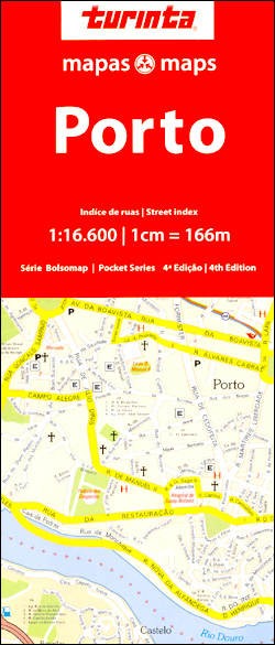
Porto on an informative and clear street plan at 1:16,600 from Turinta, Portugal’s leading map publisher, which covers the districts north and south of the River Douro and extending northwards to the city’s main port. Main sites and places of interest are prominently highlighted.The map covers the area within the IC1 and IP4 motorway ring and also shows the main approach routes to the city. Colours distinguish different road sizes, zones and parks. Specific detail includes metro underground lines and stations, railways and ferry locations. Arterial traffic routes and car parks are also highlighted. A range of symbols indicate tourist information centres, churches, municipal buildings and local public services. The map is fully indexed alphabetically. A detailed inset shows the entire Metro route with a complete list of every station on the network. Map legend includes English.

Related Products:
 Lisbon Pocket Map
 Porto Michelin City Plan and Index
 Hungary – soft cover
 Rome & Southern Italy ITMB
 Amsterdam F&B
 Palermo TCI Street Plan
 Oslo / Bergen & South of Norway ITMB
 Helsinki City Map
 Singapore F&B
 Mexico Pacific Coast & Guadalajara ITMB
 St Petersburg Marco Polo City Map
 Coast Around Lisbon Turinta
 Bangkok Marco Polo City Map
 Mexico Central & Mexico City ITMB
 Santiago de Chile Trekkingchile Street Plan
 Budapest City Plan
 Prague Street Atlas
 Bilbao Michelin City Map
 Bilbao / Bilbo
 Kolkata / Calcutta Street Atlas
 Mexico Pacific & Guadalajara ITMB
 Seville Central
Algarve Turinta
Seville Central
Algarve Turinta
 Bratislava – Slovakia
 Vienna F&B
 Tunis
Tunis
 Santiago de Chile
 Finland Road Atlas GLOVEBOX, SPIRAL-BOUND
 Hong Kong Marco Polo City Map
 Moscow ITMB
 Bay of Porto Conte to Platamona
 Hungary – Budapest Road Atlas SPIRAL-BOUND
 Skopje
 Padua TCI Street Plan
 Brussels Hike & Bike Map
 Amsterdam Michelin City Map
 Porto Rotondo to Capo Comino
 Porto, Wait for Me
 Helsinki & Southern Finland ITMB
 Montrรฉal Borch