Disclosure : This site contains affiliate links to products. We may receive a commission for purchases made through these links.
Porto CNIG Topo 228-4


Related Products:
 Porto Cristo CNIG Topographic Map 700-4
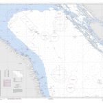
 Admiralty Chart 331 – Approaches to Porto de Belem and porto de Vila do Conde
 SHOM Chart 7228 – Abords de Venise (Venezia) – De Porto Levante ร Porto di Lido
Admiralty Chart 1480 – Porto Marghera and Porto di Chioggia
SHOM Chart 7228 – Abords de Venise (Venezia) – De Porto Levante ร Porto di Lido
Admiralty Chart 1480 – Porto Marghera and Porto di Chioggia
 Admiralty Chart 587 – Porto de Paranagua and Porto de Antonina
 Admiralty Chart 598 – Porto de Vitoria and Porto de Tubarao
 NGA Chart 54115 – Otok Drvenik Mali to Otok Susak and Porto d`Ascoli to Porto Corsini
 Gor CNIG Topo 993-4
Ena CNIG Topo 209-1
Ara CNIG Topo 210-1
Foz CNIG Topo 9-4
Ona CNIG Topo 136-3
Gor CNIG Topo 993-4
Ena CNIG Topo 209-1
Ara CNIG Topo 210-1
Foz CNIG Topo 9-4
Ona CNIG Topo 136-3
 Porto Santo (Ilha de Porto Santo) – Madeira 14
Tinajeros CNIG Topo 766-3
Toledo CNIG Topo 629-3
Carmonita CNIG Topo 752-2
Benalua CNIG Topo 993-3
Pareja CNIG Topo 537-4
Torralba CNIG Topo 586-2
Belmonte CNIG Topo 689-3
Los Cortijos CNIG Topo 736-1
Alatoz CNIG Topo 767-1
Alcubillas CNIG Topo 813-1
Lalin CNIG Topo 154-1
La Bana CNIG Topo 229-2
Mombuey CNIG Topo 268-4
Castrogonzalo CNIG Topo 308-2
Najera CNIG Topo 203-3
Arguedas CNIG Topo 244-4
Zudaire CNIG Topo 140-1
Escuain CNIG Topo 178-2
Sos del Rey Catolico CNIG Topo 207-2
El Bayo CNIG Topo 245-4
Baamonde CNIG Topo 47-3
Cuadros CNIG Topo 129-4
Villamejil CNIG Topo 160-3
Silvan CNIG Topo 191-4
Ledigos CNIG Topo 196-4
Torquemada CNIG Topo 274-4
Villarramiel CNIG Topo 272-4
Porto Santo (Ilha de Porto Santo) – Madeira 14
Tinajeros CNIG Topo 766-3
Toledo CNIG Topo 629-3
Carmonita CNIG Topo 752-2
Benalua CNIG Topo 993-3
Pareja CNIG Topo 537-4
Torralba CNIG Topo 586-2
Belmonte CNIG Topo 689-3
Los Cortijos CNIG Topo 736-1
Alatoz CNIG Topo 767-1
Alcubillas CNIG Topo 813-1
Lalin CNIG Topo 154-1
La Bana CNIG Topo 229-2
Mombuey CNIG Topo 268-4
Castrogonzalo CNIG Topo 308-2
Najera CNIG Topo 203-3
Arguedas CNIG Topo 244-4
Zudaire CNIG Topo 140-1
Escuain CNIG Topo 178-2
Sos del Rey Catolico CNIG Topo 207-2
El Bayo CNIG Topo 245-4
Baamonde CNIG Topo 47-3
Cuadros CNIG Topo 129-4
Villamejil CNIG Topo 160-3
Silvan CNIG Topo 191-4
Ledigos CNIG Topo 196-4
Torquemada CNIG Topo 274-4
Villarramiel CNIG Topo 272-4