Disclosure : This site contains affiliate links to products. We may receive a commission for purchases made through these links.
Port Elizabeth Pocket Tourist Map
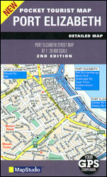
Port Elizabeth Pocket Tourist Map is an indexed street plan at a scale of 1:20,000, suitable for use with GPS systems. Road detail includes freeways, through routes and minor roads, as well as indicating one way streets, parking facilities and petrol stations. Railways lines and stations are marked and the bus/taxi terminus is located. Colour coding distinguishes land use e.g. retail areas, industrial areas and park/sports recreation areas. A range of symbols indicate sites of municipal and visitor interest such as vantage points, places of cultural significance, tourist information centres, theatres and cinemas, shopping centres, police stations and hospitals. Hotels and guest houses are shown throughout the city. For GPS users, lines of latitude and longitude are displayed at intervals of 0.5’.

Related Products:
 Bloemfontein Pocket Tourist Map
 Johannesburg Map Studio Pocket Map
 Dublin City Centre Tourist Map
 Anyksciai Regional Park Tourist Map
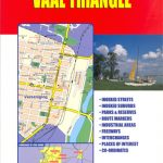 Vaal Triangle
 Ukraine: Crimea Tourist Atlas
 Lisbon Pocket Map
Grazute – Sartai Regional Parks Tourist Map
Lisbon Pocket Map
Grazute – Sartai Regional Parks Tourist Map
 Brasov Region Tourist Map
 Winnipeg Pocket Street Atlas
 Pamirs Gecko Tourist Map
 Alt Cardener – el Port del Comte
 Czech Republic 100K Tourist Road Atlas
 Highlands of Scotland Leisure and Tourist Map
 Caithness & Sutherland Nicolson Tourist Map
 Skye and Lochalsh Leisure and Tourist Map
 Kavango Region Tourist Map
 Latgale South Jana Seta Tourist Map
 Kurzeme South Jana Seta Tourist Map
 Central Latvia Jana Seta Tourist Map
Kurzeme North Jana Seta Tourist Map
Central Latvia Jana Seta Tourist Map
Kurzeme North Jana Seta Tourist Map
 Wild Coast: East London – Port St Johns – Port Edward
 Vidzeme North Jana Seta Tourist Map
 Julian Alps West Kartografija Tourist Map
 Stockholm Tourist Map
 Carpathians Kartografija Tourist Map ENGLISH
 Ljubljana and Environs Kartografija Tourist Map
 Orkney – Shetland Islands Leisure and Tourist Map
 Outer Hebrides Leisure and Tourist Map
 Windhoek
 Mรกtra Cartographia Tourist Map 14
 Primorska Kartografija Tourist Map
 Zselic Cartographia Tourist Map 17
 Gerecse Cartographia Tourist Map 10
 Kolkata / Calcutta Street Atlas
 Outer Hebrides Philip`s Leisure and Tourist Map
 The Cotswolds Red Books Leisure and Tourist Map
Gemenc – Szekszard-Hills Tourist Map
The Cotswolds Red Books Leisure and Tourist Map
Gemenc – Szekszard-Hills Tourist Map
 Borzsony Cartographia Tourist Map 5
 Vรฉrtes Cartographia Tourist Map 20