Disclosure : This site contains affiliate links to products. We may receive a commission for purchases made through these links.
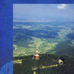
Polhograjsko Hribovje Slovenian Alpine Club 25K Map
Polhograjsko Hribovje area at 1:25,000 in a series of contoured, GPS compatible recreational maps from Planinska zveza Slovenie – Slovenian Alpine Club, covering Slovenia’s popular hiking regions at 1:50,000 or 1:25,000. Contours are at 20m intervals and the map has a 1km UTM grid plus 1’ margin ticks. On the reverse are details of two mountain shelters in this area.Maps in the Planinska zveza series titles have contours enhanced by shading and graphic relief in the mountainous areas. An overprint highlights local hiking paths, indicating difficult sections. The maps show alpine huts, refuges, hostels, campsites and other types of accommodation, local bus stops, places of interest, etc. Latitude and longitude lines are at 5` intervals, with margin ticks at 1’. On the reverse, most titles also carry detailed information on accommodation for hikers, including opening times of shelters, number of beds, distances to other huts and hostels, GPS coordinates, etc. Map legend includes English. PLEASE NOTE: map numbers given to the individual titles on our website correspond to our grid and may not necessarily be the same the numbers allocated by the publishers and shown on the different grids on the reverse of the various titles.

Related Products:
 Posavsko Hribovje East: Boc – Bohor Slovenian Alpine Club 50K Map
 Ljubljana and Environs Slovenian Alpine Club 50K Map
 Grintovci Slovenian Alpine Club 25K Map
 Jalovec and Mangart Slovenian Alpine Club 25k Map
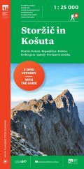
 Storzic – Kosuta Slovenian Alpine Club 25K Map
 Slovenia: Alpine Club 50K and 25K Hiking Maps
 Triglav Slovenian Alpine Club 25K Map
 Kamnik-Savinja Alps
 Stol Slovenian Alpine Club 25K
 Bohinj Slovenian Alpine Club 25K Map
 Krnsko Pogorje Slovenian Alpine Club 25k Map
 Notranjska s Sneลพnikom
 Triglav National Park
 Karavanke – Central Area
 Posavsko Hribovje Kartografija Tourist Map
 Germany and Alpine Regions of Europe: Kompass Maps of Long-distance Footpaths
 Austria: Freytag & Berndt Hiking Maps
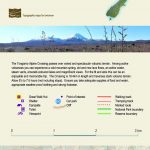 Tongariro Alpine Crossing
 Vienna Woods F&B WK011
 Skofjelosko – Idrijsko – Cerkljansko Hribovje
 Grossvenediger – Oberpinzgau F&B WK121
 Bregenz Forest F&B WK364
 Mรถlltal – Kreuzeckgruppe – Drautal F&B WK225
 Matrei – Deferggen – Virgental F&B WK123
 Zell am See – Kaprun – Saalbach F&B WK382
 Semmering – Rax – Schneeberg – Schneealpe F&B WK022
 Tennengebirge – Lammertal – Osternhorngruppe F&B WK392
 Rasos de Peguera – Serra d`Ensija Editorial Alpina
 Styrian Winelands – Southwest Styria F&B WK411
 Kals – Heiligenblut – Matrei – Lienz F&B WK181
 Munich Alpine Foreland Cycling Map
 Lienz Dolomites – Lesachtal – Villgratner Berge F&B WK182
 Pongau – Hochkรถnig – Saalfelden F&B WK103
 Kufstein – Kaisergebirge – Kitzbรผhel F&B WK301
 Hochschwab – Veitschalpe – Eisenerz – Bruck an der Mur F&B WK041
 Schadminger Tauern – Radstadt – Dachstein F&B WK201
 Graz and Surroundings – Region Hรผgelland-Schรถcklland ‘“ Gleisdorf ‘“ Weiz ‘“ Raabklamm F&B WK133
 Tongariro Northern Circuit and Tongariro Alpine Crossing
 Wechsel – Bucklige Welt – Bernstein F&B WK422
 Radstรคdter Tauern – Katschberg – Lungau F&B WK202